Here is the view from the Space Needle at 11:10 AM, 11:20 AM, and 11:50 AM...you can see the rain falling out (called virga).
This thunderstorm is associated with a line of convection stretching out into the Pacific (see satellite photo). The thunderstorm is high-based with only modest amounts of precipitation reaching the ground.
Here is the instantaneous rain rate at 11:48 AM and 12:03 PM...pouring over southeast Seattle..heading toward Mercer Island. Downtown Seattle is only getting a "taste" of the action.
Here is the storm total from Seattle Rainwatch. A lot of folks from Sea-Tac to Mercer Island to Bellevue received .2 inches. Some as much as .5 inches. Those locations can really back off on watering during the next week.
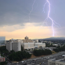
There have been dozens of lightning strikes during the past 1/2 hr...here is one photographed by Aaron Brethorst looking towards the southeast.
Was it forecast? The National Weather Service did have a chance of showers and thunderstorms in the forecasts todya.


I assume this is going to lower the temperature today from the expected high of 86/87F right?
ReplyDelete"Was it forecast?"
ReplyDeleteCliff, do you have any insight why the National Weather Service did not forecast it? I was totally buffed this morning to see the clouds coming in, water droplets and lightning in Queen Anne (or its vicinity).
Were the thundershowers in the 3 AM forecast, as well as the 10:46 AM revised forecast? The news forecast I listened to at 6:30 didn't include them. Temp only feels like mid 70s or so, I am doubtful that it will make it to the forecast mid 80s to low 90s. Is there an online archive of NWS forecasts?
ReplyDeleteBellevue (140th NE & 520) is just wrapping up an excellent 15-minute gully washer. I'm sure all the plants are glad for a visit from Nature's sprinklers. I just hope I didn't leave the wrong windows open at home! :-)
ReplyDeleteI'm in bellevue and saw some significant cloud rotation, counter clockwise, on the trailing edge of the storm.
ReplyDeleteIt wasn't forecast at all! I check weather.com and it was supposed to be 90 degrees today with some clouds in the morning and only a 20% chance of rain. Today's weather is what they predicted for Friday.
ReplyDeleteLots of thunder and lightning followed by several waving downpours here in east factoria/south bellevue area about 30 minutes to an hour ago.
ReplyDeleteSomeone I know in Bellevue claims it was snowing for about a minute. Yea, they insist it was snow. Not hail. In Redmond I saw hail. Is there any mechanism in a thundercell like this for snow to form?
ReplyDeletePatrick,
ReplyDeleteThe scientific forecaster discussion posted at around 4am missed the convection for Wed, but did talk about some on Thurs. My take is that this was miss until it showed on the radar.
Here's the link to the 4am update (that explains the basis for the early morning forecast):
http://www.wrh.noaa.gov/total_forecast/getprod.php?afos=xxxafdsew&wfo=sew&font=120&version=1
How does the "real rain" thar you forecast yesterday look now? More/less likely? It was nice to hear thunder and see actual rain drops even if it was far too brief. Today was my first time seeing actual rain drops since I moved here! I'm hoping Friday will be my first measurable precipitation...
ReplyDeleteLiz- In short, NO.
ReplyDeleteThe hail might have been partially melted as it hit on windshields, looking like some wet snow to someone who didnt know any better.
But this was a strong convective shower, with temps far above what would be needed for snow to reach the surface. Hail yes, snow, no way.
Normandy Park - 0.12"
ReplyDeleteSeatac - 0.30"
Boeing Field - 0.04"
I had a modest thunderstorm in north Bothell about noon. Very modest rain, maybe a tenth of an inch.
ReplyDeleteLiz: No way could it be conventional snow. It must have been graupel- soft hail.
That's interesting in the comment above. I have friends camping in Long Beach WA and they said they were awaken by quarter sized hail, but it was very soft like snow. What would have caused that?!?
ReplyDeletehttps://www.youtube.com/watch?v=MaoeMLsTxrY
ReplyDeleteThis is just west of Seward Park.
Looked like soft hail in Tacoma too - it definitely got very warm later in the day.
ReplyDeleteThe Hail partially melts as it comes through the warmer air
ReplyDeleteCliff,
ReplyDeleteI sure hope that you folks have nailed the Friday rain.
Please.