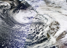
As the "Drunken Storm" waddles towards us, the afternoon satellite imagery was stunning. Here is the MODIS visible satellite image earlier this afternoon. My attempt to mark it up for explanation is found in the second image below.
This is a complex system. The primary low center is offshore, within the swirl of clouds (identified by "A"). A weaker circulation is found closer to shore at "B."
There is a VERY large area of very unstable air south of the low centers (part of which is indicated by the bluish oval). Cold air showers have been moving in on us today, explaining the intense, but brief rain. I have rarely seen such a large area of instability southeast of a low center.
To illustrate how unstable this air is, here is the IR satellite image at 4 PM, with the lightning strikes of the previous hour sensed by the UW WWLLN lightning network. Lightning is associated with the more vigorous and deeper convection. Note how the lightning is associated with the "popcorn-looking" instability clouds.
The Langley Hill National Weather Service radar near Hoquiam shows the offshore showers, and will illuminate the approaching storm tomorrow.
You have to admit, weather graphics are beautiful in their own right...nature's art.
____________________
KPLU Takeover Information
More media coverage of the KPLU takeover by the UW is found here. The PLU administration has been playing unethical games, preventing the PLU regents from seeing the highly critical KPLU Advisory Committee report. The PLU administration has also been preventing critical comments from being placed on their social media sites. Unbelievable from the leadership of a religious-based college.
The UW and KUOW continue to spread false information that the only way to save KPLU is with a UW takeover.
Good information on the UW buyout of KPLU is found here.
And the KPLU Acquisition Facebook page is here.


.. A perfect example of the idea that certainly at times whatever main low center generated part of a system is merely a by-product of its main driver. Cold are movement. Fairly obviously, and with having been for the past day and a half or so, main cold air mass has been moving strongly SE, largely independent of the main "low" in the picture, and if associated.
ReplyDeleteAnd then we have that tornado in Battle Ground. A freakin' mid-December tornado with 36 homes damaged. How often does that happen?
ReplyDeleteThis storm is indeed acting mighty drunk. But it's all very interesting weather (although the folks with the damaged homes might use another word).
Is there any snow I that unstable air?
ReplyDelete