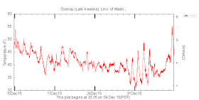
When I got back to my department, I was surprised to learn that the temperature on the top of my building had surged to 55F! (see plot below)
And as this additional plot shows, we enjoyed the warmest temperature in at least a month (4 weeks are plotted below)
At the same time, eastern Washington was stuck in cold temperatures and low clouds. The visible satellite image at noon Wednesday clearly showed the story.
Some delicate cirrus over the Puget Sound basin, clear over the western slopes of the Cascades and socked in with low clouds east of the Cascade crest.
The high temps on Wednesday reflected this (see below). Fifties to mid-fifties around Puget Sound and extending to the coast, thirties to the east.
Ironically, the warm in the west and the cool, cloudy east are caused by the same feature: a strong low off our coast, with higher pressure inland. The forecast map for 1 PM Wednesday at around 5000 ft (850 hPa) is shown below with heights (like pressure), temperature in color shading, and winds. At this level, the low is causing southerly flow aloft that has moved warmer air above the Northwest.
So why isn't it equally warm on both sides of the mountains? Let's look at a lower level, viewing a map with sea level pressure, surface winds, and temperatures at a few thousand feet and at the same time. Similar to 5000 ft, but with noticeably higher pressure and modestly cooler air east of the Cascades.
Enough hints...lets go through it. Cooler air was trapped in the basin of eastern Washington (see terrain map)
That cool air, which was saturated enough for lots of low clouds, was in no rush to get mixed out between there was an inversion (temperature increasing with height) at the interface between cool and warm air. See the vertical sounding at
Pasco, WA at 1210 PM to show this. HUGE inversion with 60F temperate at 5000 ft and low 30s near the surface.
Inversions are very stable and are difficult to remove.
West of the Cascades, there was offshore easterly flow that increased midday Wednesday as the low moved into position, while higher pressure held east of the Cascades. The time-height cross section (see below) of winds and temperature above Seattle Tacoma Airport today showed this (time increases to the left and are in UTC/GMT). Heights are in pressure (850 hPa is around 5000 ft). The easterly flow helped move the warm air down to the surface, with downslope warming due to compression, zipping the temperatures up a bit.
Why were the warmest temperatures limited to Puget Sound, the central coast, and a few locations on the western Cascade foothills? Because that is where the warm easterly flow aloft was able to surface to the ground.
It looks like essentially dry conditions for Washington State through early next week, with high temps in the lower to mid 40s. Canonical El Nino pattern.
You want lots of rain? Go to California. Want very, very cold air? Go to Minneapolis with the Seahawks.


Interesting ~ but not the case here in north Whatcom County. Scratching my head over the warm temps reflected on your visual above. Struggled to reach 40s here.
ReplyDeleteHow nice for Seattle. At my place, in Olympia, the high was 42. Nicer than the 20s and 30s that we have been having but not up to the 50s.
ReplyDeleteDitto to what the others have said. In Snohomish County we struggled to get out of the 30s yesterday. Today looks like more of the same.
ReplyDelete42 tops outside of Sequim.
ReplyDeleteSame in my case. 42 was the high in Duvall. Some clearing for about 20 minutes around 1:00 or so, then back into the clouds. As soon as nightfall occured, temperatures quickly dropped back below freezing.
ReplyDeleteToday, we had some drizzle.
Dear Professor Mass,
ReplyDeleteIf you have time, please listen to the NOAA marine weather radio forecasts, over the holidays they seem to have changed their automated voice program, and the forecasts really are not being given in very understandable English any more, things such as "for the Straits of San Juan Delaware Fuca" ...this has made the forecasts really hard to understand...wonder what can be done
thanks for your informative blog
best
Claire