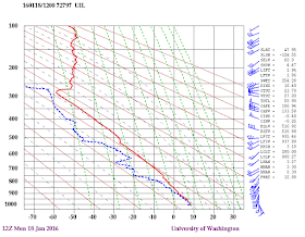
You might argue that in the midlatitudes the winds should be predominantly southwesterly or westerly (from the west), as illustrated by Monday morning's vertical radiosonde sounding at Quillayute on the Washington coast (see blue wind pennants below), since winds are generally westerly in our part of the midlatitudes.
But if you guessed westerly you would be wrong.... easterly winds are far more prevalent in the passes (such as Snoqualmie or Stevens). To prove this, here are the wind directions and speeds at Snoqualmie and Stevens during the past ten days, secured from the nice Northwest Avalanche Center website.
Snoqualmie Pass
Steven's Pass
Most of the time, the winds are EASTERLY, with occasionally westerly periods (with stronger winds) when fronts move through.
But then what is going on at the ridges, saying at the top of Crystal Mountain at 6830 ft?
Crystal Mountain
VERY different. Winds are rarely easterly, but are typically southerly to westerly. Much more like the coastal radiosonde in the free air, which is expected since high crest-level stations have good exposure to the prevailing winds and are far less impacted by terrain or gap effects on wind direction. There can be some acceleration of the winds on peaks or crests.
So that is going on? The answer is that winds in gaps in the mountains, such as Snoqualmie and Stevens, tend to reflect the pressure differences across the gaps. The same is true of the Columbia Gorge. If pressures are higher in eastern WA than western WA, there are generally easterly winds, the opposite westerly winds.
During much of the winter there is cold, dense air in easterly WA (which causes the pressure to rise). In contrast, low pressure centers are frequently offshore or approaching our coast. This configuration results in higher pressure in eastern than western Washington most of the time.
For example, on Monday a trough of low pressure was approaching the coast and that produced an east-west pressure difference (gradient) over WA state (see pressure forecast for 10 AM Monday below).
In contrast, when a front moves through the situation changes. The front has a pressure trough associated with it and temporarily reverses the pressure gradient (higher pressure to the west of the Cascades). Here is a nice example of such a reversal that occurred on January 13th at 1 PM. The result is westerly flow.
As low centers approach the coast, the pressure difference across the Cascades increase, producing strong easterly flow. That can draw some of the cool, foggy air in the "bowl" of the Columbia Basin up into the passes. This happened yesterday, something I experienced first hand while cross country skiing near Easton, WA. As a trough approached the coast yesterday afternoon, fog and low clouds thickened east of the pass. Here is my view at around 3 PM. Beautiful snow, but lots of low clouds!


ReplyDeleteDr. Mass,
My question refers to your previous blog post;
Has the CASA Radar System been considered to help w/ the radar blind zones, in your neck of the woods?
KR...yes it has. The CASA radars have a very small range and thus are inappropriate for coastal radars that need to see far offshore. They might be suitable along the eastern slopes of the Cascades..cliff
ReplyDeleteProf. Mass,
ReplyDeleteHow does this affect temperature in the passes? Does the easterly flow bring lower temps with it?
-Gabe
Keep up the good work, Cliff. I'm in Arizona, but I have relatives in the NW and read your blog often. It's like a breath of fresh air through the smog of media hype. A shame that our school system doesn't seem to be teaching "critical thinking" as you demonstrate it.
ReplyDeleteIt seems that the story for Thursday west of the passes is "heat wave from the south", far overpowering any cooling from the east. Friday very early morning looks notably warmer than the latter part of the morning and throughout the day; it seems the winds aloft are helping that trend. I haven't looked outward to see what might be causing that, but I was hoping the snow would freeze overnight. No such luck.
ReplyDeleteIt seems that Friday's planned day in the snow will be quite sloppy. I might have to find somewhere east of the passes.