These fires have also started the mid to late summer smoke season, as indicated by a high-resolution MODIS satellite image from Monday afternoon. Look carefully and you will some subtle smoke around Hanford and over Idaho.
Two days ago, there was even a modest fire in the Olympics, as shown by this aerial shot taken by Ed and Clare Kelm of Roche Harbor. I flew in from the west that day and saw some of the smoke in Olympic valleys myself.
Why the fires now? The key factor was the surge of warmth last week. The plot of temperatures at Pasco, Washington for the past few weeks says it all, with temperatures rising above the mid-90s for 6 days in a row, which drops the relative humidity way down and dries out the surface fuels (like grass).
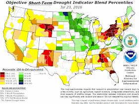
What ignited the fires? Either careless humans or lightning. Although the last few days has had little lightning, there was plenty a week ago. A lightning strike can produce a smoldering, low-level fire that explodes when temperatures surge.There is no reason to expect an above normal fire season this year. Streamflow, snowpack, and soil moisture are near normal, and the short-term drought indicator (produced by NOAA) shows nominal conditions.
And as noted by previous blogs, an upper level trough is bearing down on us (see upper level map for today at 8 AM) and we expect precipitation during the next day or so in the mountains and western
Washington (see 72h totals below). We do expect some lighting with the rain, so that could initiate fires.
We do appear to be in a cooler pattern, with another cool/wet lupper ow ready to move in for this weekend (see upper level map below). Model forecasts suggests that this will be a wetter system (and yes, this is supposedly the driest time of the year).


55 degrees this morning in north Seattle. On August 2.
ReplyDeleteI will take that any time.
Troughing must but the new thing this year, but is that so bad after years of ridging, especially the last two summers? Who knows, maybe ridges will be the norm for winter after this trough pattern shifts?
ReplyDeleteI don't like that wind has been more frequent than I can ever remember here in Central Washington, but aside from heat spikes here and there, this has been a really nice, pleasant summer and I hope that trend continues well into September.
Dang, Cliff. When in the heck is it gonna rain in West Seattle?
ReplyDeleteThis 80% stuff just hasn't cut it all spring and summer.
There are four fires in Olympic National Park. The largest 64 acres and the smallest 1/4 acre and all were started from the lightning storm last week that recorded 400 strikes. It's been awhile since that happened. The cooler weather has quieted them down pretty much.
ReplyDelete"When in the heck is it gonna rain in West Seattle?"
ReplyDeleteLate September maybe? October?
So far this summer has been wetter than normal for Seattle, with June at 113% of normal and July at 103%. It's just that 103% of .7 inches (normal July precip in Seattle) is only .72 inches.
Summers in Seattle = sun. Bluest skies you've ever seen. Sing it with me! (must be old enough to remember tv in a box to get that reference)