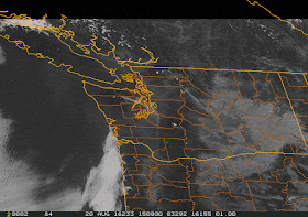
Yesterday, Seattle-Tacoma Airport got to 95F, breaking the previous daily record, while Willamette Valley locations hit the century mark (see Friday max temps below). Ironically, eastern Washington cooled substantially from Thursday due to a surge of cooler air from the north (and which was MUCH stronger over Montana).
Temperatures should be similar over the western WA and Oregon interiors today, but a push of marine air is expected tomorrow west of the Cascade crest as a significant trough of low pressure moves through.
The coast should be cooler today, as the offshore flow weakens and the thermal trough moves inland. The visible satellite imagery this morning shows a sign of this....a tongue of stratus hugging the coast. You will also notice the plumes of smoke from a few fires over the Olympics and Cascades.
Temperatures above Seattle are just as warm this morning as yesterday and the low level northerly winds (which cool) are weaker (as shown by the time-height cross sections from the profiler at Seattle Sand Point below).
The UW WRF high resolution model surface temperature forecast for 5 PM (below) shows very warm temperates again over the Willamette Valley and southwest Washington (96-100F), with lower 90s extended north to the southern Puget Sound. Cooler along the coast.
Sunday will bring a major push of marine air and temperatures dropping by 10-20F. The latest numerical forecasts suggest an even stronger ridge of high pressure building mid to late week, with temperatures climbing again into the 80s and 90s. (see sample below). The wildfire threat is increasing, as the above normal heat dries the surface fuels.


That would truly be an extreme bookmark to this summer's fluctuations if we over achieve late next week! This has been fascinating to have the second earliest 100 degree temp in the Portland area (beginning of June), followed by the second latest 100 degree reading this August. Lots of very important/useful information collected by us weather geeks from these patterns to use in summers' to come. 850 MB temps vs. east winds, and humidity as low as 10% in Portland. Thanks for all the info, and I will really be interested to see how the 850 MB temps vs. lower sun angle come into play next week!
ReplyDeleteI thought we might have a cooler than normal summer. But, these August heat waves put the kibosh on that idea. This will be our 4th consecutive summer of above normal temperature.
ReplyDeleteI'm under the impression that something is glitched with the '3 day history' recorded for the "Weather Conditions - Seattle, Seattle Boeing Field, WA. KBFI (NWS/FAA)", URL:
ReplyDeletehttp://www.wrh.noaa.gov/mesowest/getobext.php?wfo=sew&sid=KBFI&num=72&raw=0
Was there really a 10 degree drop this evening in only 5 minutes?
20 Aug 7:53 pm 83 50 32 WNW
20 Aug 7:50 pm 82 50 33 WNW
20 Aug 7:45 pm 91 52 26 WNW
20 Aug 7:40 pm 91 52 26 WNW
and obviously, it didn't get down to 68 degF this afternoon. Does the recording mechanism have dyslexia?
20 Aug 3:10 pm 88 55 33 NW
20 Aug 3:10 pm 88 55 33 NW
20 Aug 2:35 pm 68 32 26 WNW
20 Aug 2:25 pm 68 32 26 WNW
...
20 Aug 2:00 pm 68 32 26 WNW
20 Aug 1:53 pm 68 55 64
20 Aug 12:53 pm 82 57 43 WNW
20 Aug 11:53 am 82 55 40 WNW
I'm assuming that this is one of the things that happen when raw data is shared real-time, and that it will be caught and corrected? Or will it go down in history as a mid-day temp of 68 deg for this day? Can you comment?
Is there another blob forming off the coast? SST anomaly map is showing a big red area.
ReplyDelete