The jet stream and Pacific moisture that is...and today is going to be a soggy day around the Northwest. No hiking for me today.
Let's start with a recent infrared satellite image (remember infrared imagery tells us the temperature and thus height of clouds, white being higher). You see a stream of clouds extending west-cast over vast distances over the Pacific, with particularly high (and precipitating) clouds over our region?
But infrared satellite imagery don't actually show water vapor, just clouds and the surface. You want to see water vapor? No problem. Our satellites look down in multiple wavelengths, including the water vapor channel, which is sensitive to the emission of radiation by water vapor. (image below) Now you REALLY see the situation...a plume of high moisture values in the upper troposphere (indicated by lighter colors)
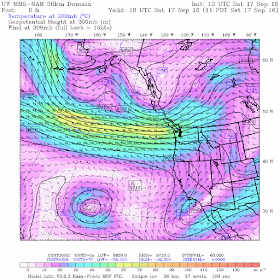
The current of moisture is associated with the midlatitude jet stream, a current of strong winds in the upper troposphere that is generally strongest between 25,000 and 35,000 ft. Here is a map of forecast winds at a pressure of 300 hPa (around 30,000 ft). The yellows show winds of roughly 60 meters per second (roughly 135 mph)--twice as fast as freeway speed. Jet stream winds can get considerably strong than this in midwinter (200-250 mph).
Such a strong jet causes major alterations in the paths of commercial jet liners.
For example, the typical path from Tokyo to Atlanta would follow the great circle route that would pass over Alaska. (see below)
But because of the strong jet, today's flight (Delta 296, which is practically over Seattle now!) headed nearly due west to take advantage of the strong tailwinds from the jet stream. A longer route can be faster with a powerful jet sream behind you.
With westerly flow aloft, there is significant rain shadowing to the lee (east) of the Olympics and Cascades. The radar imagery around 9:22 AM this (Saturday) morning illustrates this. There is a hole of little precipitation downstream of the Olympics and little rain on the eastern slopes of the Cascades. The back edge of the main rain band is crossing the coast.
Tomorrow will be far drier, with the 24h totals ending 5 AM Monday being relatively light over most of Washington, with a few residual showers over the western slopes of the Cascades. Oregon gets more tomorrow.
A good day to catch up on chores in your home or apartment. Or go see the melting ice cube in Pioneer Square. 8 days and counting!
My talk on Northwest Climate Surprises on September 28.
During the evening of September 28, I will be giving a talk in Seattle at the Mountaineers in NE Seattle on Climate Surprises: Unexpected Impacts of Global Warming on the Pacific Northwest.
You think global warming will simply bring warmer temperatures, drought, less snow, and more storms?
Think again. The latest climate model simulations provide a far more nuanced prediction of what will happen here, with some of the predictions being quite surprising. This talk is sponsored by CarbonWa and the Audubon Society. To find out more or to secure tickets, please go here.
And if you already secured tickets please not that the location has been shifted to the Mountaineers location in NE Seattle (in Magnuson Park). Parking will be easier and free. Right near Sand Point Way (lots of buses) and the Burke Gilman trail.


The simplest rules for trans-Pacific aircraft operations are to always fly Great Circle Routes (they're shorter) unless you can take advantage of winds.
ReplyDeleteGiven the prevailing westerlies, westbound flights avoid the jetstream (all winds really) like the plague, and the eastbound flights seek it out with the same enthusiasm. When the jetstream comes south as it has now, that means the shorter-distance westbound Great Circle Route over Alaska is going to be faster than usual and smooth as silk. Eastbound flights are always faster (sometimes MUCH faster) than westbound, despite not following the shorter GC route.
Side note from someone who has flown the Pacific hundreds of times: westbound flights are on the average smoother than eastbound flights given that eastbound flights try to get into the jetstream, which often creates mild turbulence, sometimes most of the across the pond. Not enough for the seatbelt warning, but enough to bother sensitive passengers. But you get off the plane and hour or two earlier than westbound.
John Marshall: Man I wish there were more intelligent and thoughtful posters like you on this blog. I enjoy reading your posts as they always seem to be interesting, fair and I learn from them. Like the one above, this is a great post and contained some stuff I didn't know. Thanks for these and please keep up the good. Cliff, also enjoy your posts, so please also keep up the good work and thank you.
ReplyDeleteSorry Cliff, your Monday forecast is off target: convergence zone leaves us soggy in NE Seattle!
ReplyDelete