Or we can look at the average of many forecasts (the ensemble mean) for the same level, in this case for Sunday at 5 PM. This figure also shows the anomaly--difference from normal--with color shades. Big trough over the NW coast, which means cooler and wetter.
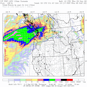
Over a 24h period ending Saturday at 5 PM, good rain along the coast and western Oregon, but only light rain reaching Puget Sound
Ditto on Sunday.
For the next 24h (Monday), still wet over the coast and offshore, but not much over the interior.
On Tuesday, significant rain engulfs western Oregon and Washington.
And then much wetter conditions on Thursday.
Bottom line: if you keep away the coast, this weekend will be tolerable and eastern Washington should be pleasant. But wetter conditions are expected later in the week over both sides of the Cascades.


Snow on ths ski slopes?
ReplyDeleteOctober is supposed to be the rainy season in the PacNW. We should be receiving close to an inch of precip a week in Seattle. Based on the QPF charts, it looks like we will have trouble wringing even a quarter inch altogether out of these storms. It is strange because the 6 to 10 day and 8 to 14 day have been showing a wetter than average spell, but this is certainly not what I would consider above average precip.
ReplyDeleteIsn't October 1 the start of the official rainy season?
ReplyDeleteIf so, then I will paraphrase Tolkien:
"The rain is never late, Frodo Baggins. Nor is it early. It arrives precisely when it means to."
Rain is pleasant.
ReplyDelete