The meteorological community (and U.S. taxpayers) enjoyed a sigh of relief as the newest U.S. weather satellite was successfully launched from Kennedy Space Flight Center last night at 6:42 PM EST.
As I will describe below, this satellite not only continues the critical functions of the satellite it replaces, but brings new capabilities that promise to improve global and regional weather prediction.
But such capabilities don't come cheap: the cost of this satellites and its three subsequent siblings is in the billions of dollars.
GOES-R is a geostationary weather satellite, positioned in a very special orbit over the equator at 22, 300 miles above the equator. In such a geosynchronous orbit, weather satellites can view the same portion of the earth continuously (it rotates around with the earth). By the way, GOES stands for Geostationary Operational Environmental Satellite.
There are five operational geostationary weather satellites today, two launched by the U.S., one by Europe (Meteosat), one by India (INSAT), and one by Japan (GMS). Together, this satellite provide total world coverage, except for the polar regions.
But don't worry, we have coverage there as well from another class of weather satellites called polar orbiters that have a distinctly different orbit. Polar orbiters generally fly very low (800-1000 km above the surface) and allow the earth to rotate under them.
Between the geostationary and polar-orbiting satellites, meteorologists have total and continuous view of all weather features of our planet. It is impossible for major storms to hit a coast without warning, unlike the situation before weather satellites (the first weather satellite, TIROS-1, was launched in 1970. The first geostationary weather satellite in 1975).
It should not be forgotten that the two major technologies behind operational weather forecasting is numerical weather prediction and weather satellites. Weather satellites provide over 95% of the information used to describe the atmosphere, the first step in numerical weather prediction. There are no weather data voids over our planet now..and you can thank weather satellites for that.
So why is GOES-R such an advance?
First, it has a new imager (the Advanced Baseline Imager, ABI), with half the pixel size of previous geostationary satellites. Thus, visible imagery can see 1/2 km details compared to 1 km of the past satellites. It is like going from old analog TVs to high definition. A Japanese weather satellite already has the new imager, here is an example of the wonderful clarity of the ABI imagery:
If you look closely, you can see something else....the image is in color!
The current U.S. satellites only can produce black and white imagery in the visible, but ABI observes the earth in three times more wavelengths, allowing the production of color visible images.
The new satellite can also scan much faster, giving new images more frequently. Today we get a new image over the U.S. every 15 minutes. With GOES-R that will decrease to every 5 minutes. More frequent imagery allows forecasts to follow rapidly changing weather situations (e.g., thunderstorms) and thus provide better forecasts.
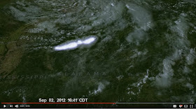
But I am particularly excited about a brand new capability of GOES-R, the ability to see lightning from space. This is made possible by a new sensor, the Geostationary Lightning Mapper, which uses optical sensors to view lightning flashes from space. There are lightning maps today from surface-based sensors that measure the electronmagnetic pulses from lightning. Unfortunately, these sensors mainly observe lightning strikes between cloud to ground and not cloud to cloud. They also have problems sensing lightning in distant areas or in the middle of oceans. In contrast, GOES-R will observe all lightning flashes.
Lightning observations are very valuable data, providing important information about the structures of the atmosphere. For example, a lightning flash suggests that the atmospheric volume is saturated, the vertical structure is unstable, and that there is ice within the clouds. This information can be used to improve our description of the atmosphere and subsequent forecasts. For example, I received some NOAA GOES-R research funding to study the implications of lightning for improving numerical weather prediction over the US. The results were quite positive.
GOES-R also has new sensors for studying the sun, including an ultraviolet radiation imager (see graphics). These sun sensor will aid in forecasting solar storms that can greatly affect communication.
I have touched upon just a few of the the impressive capabilities of the new NOAA/NWS GOES-R satellite, which be entering its final orbit and start the testing phase during the next few weeks.


When is it expected to become operational? Where will images be available. The NWS viewer page stinks. the 16 km images are too large for see details and the "higher Res" images too pixlelated to see meso feature clearly. Please let us know.
ReplyDeleteHi Cliff,
ReplyDeleteTIROS-1 was launched in 1960.
Mike
I don't understand why the NWS got rid of the 4km infared satellite resolution a few months back.The 1-2 km images are horrible as previously mentioned,and the 8/16 are too far away,and focus more on California than the North Pacific.I hope the new satellite will give better satellite image options.I have a suspicion that it will be positioned over the east coast,though.
ReplyDeleteWhat longitude will this set up over? Does it replace Goes-E W or is it a 'tweener?
ReplyDeleteAh - from goes-r.gov:
ReplyDeleteAt the conclusion of the checkout, the satellite will be placed into either the East or West location depending on the health and performance of the other GOES satellites in NOAA’s constellation.
ReplyDeleteWell, since the East Coast has more people, I suspect it will become GOES East. And we on the West Coast will have to wait when or maybe I should say, IF, they decide to launch another satellite.