The regional radar image at 2 PM was amazing and dramatic (see below). Moist flow from the west is approaching our coast, rising on the western side of the Olympics and sinking on its eastern side. The result is distinct hole in precipitation to the lee (east) of the Olympic barrier....a rainshadow. As the air rises again on the Cascades, precipitation reforms.
Why is the rainshadow over Seattle to Everett rather than over Sequim? Because of the westerly wind direction aloft rather the typical south-southwesterly flow of winter.
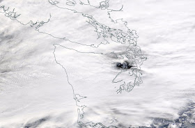
But what is really exceptional is the satellite imagery. Here is the image from the NASA MODIS satellite...you see the black, cloudless "hole" downstream of the Olympics. It is sunny there!
Here is a blow up of the "cloud shadow". Really dramatic.


Yep - we miss that blue hole in the Sequim area today. Hope you all enjoyed it while you can.
ReplyDeleteHere in Moses lake we understand the rain shadow effect. What I don't get is why the radar often shows its raining whe actually it's dry. Evaporation or bad radar?
ReplyDeleteImagine if there were no Olympics? What would Seattle be? My son follows the blog closely. Now he has moved to Portland. What sources of information books, etc can he rely on to receive a proper knowledge of the region that effects forecast and climate conditions?
ReplyDelete