_____________________________________
Here we go again. Another difficult to forecast snow event, with temperature sclose to the margin over the western WA lowlands. A situation where a number of our models suggest several inches over much of the lowlands west of the Cascades, with those poor suffering folks in Portland getting hit the hardest.
To "warm up", here are the forecast snowfall totals for the 24h ending 4 PM Sunday and 4 PM Tuesday from the UW WRF system . On Sunday there is LOTS of snow over the southern WA and northern WA Cascades....feet.
The snow around Puget Sound begins late Sunday and early Monday in the UW model forecasts. The situation late Sunday is close to the canonical snow set-up, but not ideal. As shown by the forecast surface map, very cold air and high pressure is over British Columbia, and a low center is just off of the Columbia River bars. Such a pattern helps drive cold air into western WA.
At the same time an upper trough is approaching from the west, providing upward motion that drives clouds and precipitation. This trough extends a bit too southward to optimize snow over western WA: the strongest lift is over western Oregon at this time.
The above is just ONE solution and there is considerable uncertainty. We can get an idea of the amount of uncertainty from our ensemble (many forecast) prediction systems.
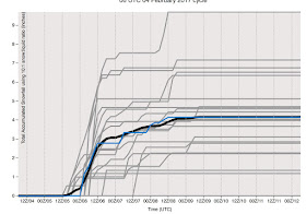
The U.S. global ensemble (GEFS) snow prediction for Seattle is shown below with the average indicated by the black line and the high resolution GFS member by blue. The ensemble mean shows a lot of uncertainty in the forecasts (big range of possibilities with the average getting to around 3-4 inches and a range from zero to 8 inches). Snow starts late Sunday and continues for several days.
Why is there substantial uncertainty? Because the air temperatures are marginal for snow and the models have variations in the forecast details.
Keep tuned...the uncertainty should decline during the next day. But it looks like the most likely forecast is 2-5 inches of snow over Seattle, with about 20% chance of little snow or over 6 inches.


Maybe a repeat of 2/1997 to follow!
ReplyDeleteI'm watching that cold Canadian air plunge southward and out into the Pacific off Vancouver Island. That's a sign of snow coming to the Olympic Peninsula.
ReplyDeleteSnow level rise all day west of Hood Canal, then apparently started falling last night and this morning as snow has moved down the hill this morning.
ReplyDeleteIn Maple Falls in the Foothills of Whatcom County, we had 10 inches of snow at 10 AM this morning. Getting snow at the rate of an inch per hour!
ReplyDeleteSclose!!
ReplyDeleteSleet, snow, and the northeaster in north Whatcom County since yesterday. Drifts of several feet in some places. Conditions up here are dangerous.
ReplyDeletePerfectly stated probabilities Cliff and sufficient warnings of the BUST potential (heavy snow and negligible snow) in either direction of the forecast.
ReplyDeleteSeattle is almost always the last place to get snow. Maybe some wet snow that melts instantly amounting to no accumulation.
ReplyDeleteAs of 4:45 PM today, now the forecast is calling for mostly rain until Sunday evening, with a dusting of snow into Monday. If this holds then thank goodness, the area cannot withstand another storm of this magnitude (if it comes down as snow). I would hope that the local politicos would try to learn something from this winter, but from what I've heard so far, that hope appears to be a faint one.
ReplyDeleteAn equally challenging forecast,too for the NWS people in Spokane. The rain/snow line is expected to vacillate around Spokane County tonight and Sunday.Spokane could end up with rain,snow,or a mix.Huge forecast bust potential,there,too.
ReplyDelete