The 10 AM infrared satellite image shows the swirl of the huge storm, with its center just offshore of the WA/OR border.
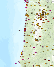
As predicted the cyclone brought strong winds along the Oregon coast (see below), with gusts to 60-70 mph. A few exposed peaks even higher.
Now it is our turn. Winds are rapidly increasing over western Washington and the max gusts so far (as of 10 AM) have reached 40- 50 mph on the southern WA coast and 72 mph at Destruction Island. Gusts to 30-40 mph have reached the south Sound and NW Washington. But you haven't seen anything yet!
The latest UW WRF model (the same one to be used in our proposed regional climate simulations) indicates a 10 AM position of a deep (975 hPa) low due west of the Long Beach Peninsula
With movement northward during afternoon (5 PM shown below).
The WA coast is going to be hit very hard, with 60-70 mph gusts.
The latest NWS HRRR (High Resolution Rapid Refresh) surface wind forecasts over western WA are scary. Here are the gust forecasts at 2 PM, 5 PM and 8 PM.
40-50 mph gusts everywhere and a number of areas (e.g. the coast, NW WA) experiencing 50-60 mph. If this is true, expect substantial tree damage and power outage.
So please keep away from trees this afternoon and tonight (such in parks or the Burke-Gilman trail in Seattle).
As of 11 AM, tens of thousands of customers have lost power over Oregon and southwest Washington. This is going to be a major event there.
________________________
Will Such Storms Increase Under Global Warming? Help Us Determine the Local Impacts of Climate Change
Society needs to know the regional impacts of climate change and several of us at the UW are trying to provide this information with state-of-the-art high resolution climate modeling. With Federal funding unavailable, we are experimenting with a community funding to build this effort. If you want more information or are interested in helping, please go here. The full link is: https://uw.useed.net/projects/822/home All contributions to the UW are tax deductible.


Hey Cliff, do you expect this storm to affect airport operations at SEATAC this afternoon? My family is scheduled to fly from Seattle to Portland at 3:00 and this storm makes flying seem a little sketchy.
ReplyDeleteIn being the strongest April storm in over 50 years and with the impacts we're getting, won't this storm need a name? Since it's April 7th, I nominate the Beer Day Storm.
ReplyDeleteSo you're telling me my bike commute home is going to suck...
ReplyDeleteGood thing we got the floating portion of the 520 bridge replaced!
The winds from this low and associated cold front have encompassed a large area,not just the Ore/Wash coastal areas: 50-60 mph wind gusts were observed in Oakland and San Jose last evening,and in Bend and Pendleton this morning.The wind now is increasing here in Spokane,and probably is gusting in the 40-50 mph range now.
ReplyDeleteIt's 2:25 pm, I'm in one of the red zones and we've got no wind. We're on the water too. I guess that's a good thing.
ReplyDeleteThe nearest Real Time weather station to me has shown on a 29mph gust as of 4pm. Not that I'm complaining! My Dish signal from the waving trees is the only problem. Not even a power flicker. Not seeing any new branches in the yard from my many trees. Just need to get through the backside of this storm until 10pm. I'll take more storms like this so far.
ReplyDeleteLOL.. that was the funniest "I am not a robot" thing!
Been watching over Sinclair Inlet and Washington Narrows here in Bremerton. Wind seems to be pretty much missing us. At least my reading from watching the water. About 1PM saw some white caps, but not many and not for very long.
ReplyDeleteThe NWAC station at Hurricane Ridge in the Olympics recorded a gust of 94 mph between 3 and 4 p.m.
ReplyDeleteMax gust of 53MPH at BLI. 46MPH at the max according to my PWS about 1.5 miles to the southeast.
ReplyDeleteWe are in Issaquah and had a huge portion of the top of a Douglas fir tree snap off about 75 feet up and land on our deck at 1:15 pm. We were lucky it just scraped the house. Must have been a high wind gust to make that happen!
ReplyDeleteExperienced this storm in Cannon Beach, Oregon. I have to say it is the strongest storm I can recall experiencing in April or any other month for that matter.
ReplyDelete