Why are the rivers so high? The main reason has been a massive snowmelt produced by a well above-normal snowpack and warmer than normal temperatures during the past week.
First, the snowpack. Take a look at the latest SNOTEL totals (percentage of normal). Much of the Northwest is well above normal---and that is after quite a bit of melt the last week.
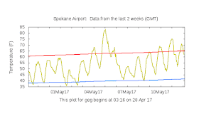
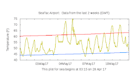
And then there was temperature. Here are the temperatures for Spokane and Seattle (yellow lines) for the past two weeks (red and blue lines are normal highs and lows, respectively). There was a surge of well above normal temperatures about a week ago (into the 80s in Spokane!) that initiated a surge of melting. And temperatures have been above normal the last few days.
Or take a look at the deviation of the temperature from normal for the past week. Really warm for much of the Northwest and northern Rockies, which is consistent with large snowmelt.
The surge of warmth (and some rain that came at the end of it), pushed some of the rivers rapidly higher. Consider the Naches River on the eastern slopes of the Cascades (see below). Huge jump to above flood stage on May 5-6th. Even today it is at bankfull and above normal conditions.
The surge of melt water was quite obvious in the total storage of the Yakima Basin (see below)--really zoomed up starting with the warm spell.
Large snowmelt and surging rivers in Spring are not unusual in our region, and was a real problem for Portland and other riverfront cities before the hydro dams were put in.
Perhaps the region's greatest spring flood occurred June 5-6, 1894, when an above-normal snowpack was melted quickly by a heat waves, pushing the flood level to 34.4 feet in Portland, and destroying the town of Cascades, Oregon. Another great flood in 1948 destroyed the town of Vanport, Oregon. With a line of dams storing much of the spring snowmelt, flooding is thankfully only a minor nuisance along the Columbia these days.
_____________________
How will Northwest Weather Change Under Global Warming? Help Us Determine the Local Impacts of Climate Change
Society needs to know the regional impacts of climate change and several of us at the UW are trying to provide this information with state-of-the-art high resolution climate modeling. With Federal funding unavailable, we are experimenting with a community funding to build this effort. If you want more information or are interested in helping, please go here. The full link is: https://uw.useed.net/projects/822/home All contributions to the UW are tax deductible.


Much cooler now--40's-- on the East Side;snow levels are dropping fast.That should alleviate the problem somewhat,although moderate rain showers are occurring.I think the next flooding concern will be on the east side of the North Cascades if we get a prolonged hot spell later this month,or in June.The Pasayten River is notorious for flooding in those conditions.
ReplyDelete500% that has to be an error???
ReplyDelete"Large snowmelt and surging rivers in Spring are not unusual in our region, and was a real problem for Portland and other riverfront cities before the hydro dams were put in."
ReplyDelete"With a line of dams storing much of the spring snowmelt..."
This is a common misconception. Most of the hydro projects on the Columbia and Snake are run-of-the-river structures that can't provide significant water storage or flood control. Only two dams in the US, John Day and Grand Coulee, provide storage and flood control close enough to the lower river to be relevant to flooding near Portland.
Keenleyside/Arrow and Duncan, in British Columbia, also provide flood control, but they were not built as hydro projects. Arrow was only retrofitted with a prowerhouse in the '90s, and Duncan is still purely a storage dam. There are also many storage dams on tributaries (Yakima, Clearwater, Flathead etc), which get most of their supply from melt. These dams do limit the pulse of snowmelt, but are too far away from the lower river, to directly control floods there.
https://www.crt2014-2024review.gov/Files/FCOP2003.pdf
Hi Cliff. Sorry this is off-topic but I can't see how to email you. Do you have any idea why spring is so late in the Pacific Northwest this year? Like almost a month late?
ReplyDeleteSee https://www.usanpn.org/data/phenology_maps
The PDO is still positive, the Easter Pacific SST has been largely on the plus side, pineapple express winds hit us regularly yet it is still cool. Any idea what gives?
Two words: La Nina
DeletePretty impressed on the amount of rainfall that has been falling in the SW interior and central and southern beaches the last couple days.
ReplyDeleteThere's a SNOTEL page related off the river map you posted. Anyways, there's a site south of Mt. St. Helens called Swift Creek (3770ft), 218 inches of precip and 106" SWE so far in the water year. That might be one of the wettest observation sites in the state, I dunno.
As an Atmospheric Chemist I had the distinct honor to work with the world's preeminent CO2 expert who coined the term Global Warming this
ReplyDeletehttps://goo.gl/photos/SvqWn9q9CeSHyTDh7
is how he explains Climate Change in 36 seconds