June 29, 2017

Start of the Northwest Wildfire Season: Lightning, Winds, and Grassoline

This week the Northwest wildfire season began, with a series of large grass fires on the eastern slopes of the Cascades (map below of current major fires).

One fire, the Sutherland Canyon fire southeast of Wenatchee was quite large, reaching 47,000 acres this afternoon (see map below).


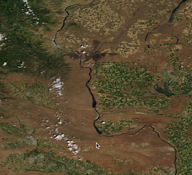
Yesterday's high resolution MODIS satellite imagery shows the smoke from the fire, which was mainly heading southeast towards Moses Lake.

You can actually see the burnt area from space. Here are two images, one from earlier this week and one today.  The blackened area resulted from the fire.


Meteorology had a lot to do with the fire....in fact, it was a classic set up.  We started with the building of high pressure over the region earlier this week that caused temperatures to surge and humidities to plummet.   Here are the temperatures over the past two weeks at Wenatchee.  Temperatures warmed towards a peak on Monday into the mid-90s.  And there was no rain during that period.

So there was considerable drying.

Then there was an initiator of fire:  lightning on Monday night as an upper level trough pushed through (see 500 hPa--around 18,000 ft--weather map at 8 PM)

Take a look at the lightning strike map for the 24 hr ending Tuesday at 1 AM.  You can see the band of lightning, associated with some modest thunderstorms, that ignited some of the grass around Wenatchee.  And started the other fires as well.

But there was something else:  strong winds that fanned the fires.   As the upper level trough went through, it brought cool air and high pressure into western WA/OR (see pressure and temperature map at 5 PM Monday). As a result, winds accelerated over the eastern slopes of the Cascades as illustrated by the forecast wind gust map for 8 PM Tuesday.

You can appreciate the wind acceleration on the eastern Cascade slopes by looking at the sustained winds and gusts at Ellensburg (see below).  Big acceleration on the 27th than extended to mid-day today.


Such winds can really stoke a fire and cause it to rapidly spread.

And there is one more thing.   A bumper crop of dried cheatgrass, also known as grassoline.  Cheat grass is a non-native, invasive grass that has taken over the sagelands of much of the west.  It grows prolifically and crowds out the native grasses, which tend to grow in isolated "clumps".  Cheatgrass not only grows well, it tends to brown out much earlier than native grasses and is highly flammable.


The spread of cheatgrass has made wildfires more severe in eastern WA, irrespective of global warming.  Similarly, poor forest practices and fire suppression on the eastern slopes of the Cascades has made forest fires far worse.  

So we had hot, dry conditions, lightning to initiate the fire, strong winds to stoke it, and an ample and highly flammable fuel supply.  All the ingredients for major grass fires.

And a message for this weekend.... folks should avoid playing with fireworks east of the Cascade crest, since the potential for major grass fires is in place.

June 27, 2017

The Truth about Northwest UFOs

Recently, the Seattle Times featured a story about a famous 1947 UFO (unidentified flying object) sighting in Washington.... the incident that started the UFO craze around the world.


And this UFO sighting is not the only one in our area.  For example, Ohio Congressman Dennis Kucinich admitted during the Democratic presidential debate on October 30, 2007 that had seen a UFO while visiting our state.  And even Seattle's most recognizable landmark, the Space Needle, is clearly a stylized form of a flying saucer.


What is the truth about this UFO mania in our region?  Is there something about our area that is attractive to visiting aliens?  Or could there be another explanation?  Something more "scientific"?  Perhaps a meteorological explanation?

The original June 24, 1947 incident involved Kenneth Arnold, a businessman from Boise, Idaho who was flying a small plane near Mount Rainier when he spotted a chain of nine "saucer-lie" objects above and east of the mountain.  Brilliant in the sun, these objects darted towards Mt. Adams an "an incredible speed', which he estimated to be at least 1200 mph.  His account went viral across the world and thus started the UFO/flying saucer craze.
 An investigation by the U.S. government revealed little, although some folks suggest that our military knows a lot more about it, including flying a captured saucer in Area 51 in Nevada.

But there is another possible, if not probable explanation.  One suggested by one of my most distinguished colleagues, UW Professor Richard J. Reed:   lenticular clouds associated with atmospheric mountain waves.

As air is pushed up by a mountain range, the air can go into an oscillation over and downstream of the mountain crest (see illustration).   When the air rises, the air can become saturated, producing lens-shaped (lenticular) clouds.

 The lenticular clouds are quite striking, often looking like flying saucers.


Professor Reed, studying the atmospheric conditions during Arnold's 1947 flight, found that they were just those expected during mountain wave cloud periods.

You can read the details in his paper "Flying Saucers over Mt. Rainier" in the April 1958 of Weatherwise Magazine.   And what about the movement of the "flying saucers"?   Dr. Reed noted that if atmospheric conditions approaching Rainier were changing, the location of the lenticular clouds could rapidly shift, give the impression of rapid movement.

But what about Congressman Kucinch?  What did he see?   One might note that Presidential candidates have a tendency to imagine things, but lets put that aside for a moment.

Where was the Congressman when he saw the flying saucers?   Staying at Shirley McLane's home in Graham, Washington (red color in map)--a location very close to Mt. Rainier!


Mount Rainier, the region's most massive volcano is the most prolific producers of lenticular clouds.  No wonder its a focus of UFO sightings.

When I was an undergraduate at Cornell, I worked with Professor Carl Sagan, who had a lot to say about UFOs.   He told me that that although he was convinced that intelligent life was prolific around the Universe, traveling interstellar distances would verge on the impossible.  He was very skeptical that any of the UFO sightings were real...and that they said more about folks psychological state than aliens visiting our planet.

June 25, 2017

Cool Air is Starting to Move In

Today broke several daily temperature records,  with temperature climbing into the mid nineties around Seattle and upper 90s to the east.  The interior of SW WA and the Portland area jumped to 100F and more, as did the Tri-Cities.

Here in Seattle, temperature were quite pleasant on Puget Sound, but jumped into the mid-90s over NE Seattle.   Even hotter over Bellevue and Redmond.


But as forecast, everything is changing now.  The trough of low pressure (the thermal trough) has jumped over the Cascades and an onshore pressure gradient has developed (see pressure difference table below). The Hoquiam minus Seattle pressure difference jumped to 3.5 hPa...guaranteeing the inland movement of cool air.

The winds  and temperatures above Seattle Tacoma Airport show the incipient changes,  with hot SE winds replaced by cooling southwesterlies aloft.  And temperatures aloft are falling.
Coastal clouds have moving northward and thickening during the day (see satellite image from an hour ago) and those clouds will move in overnight.


I look forward to hearing the tinkling of my wind chimes around midnight, a sign of the influx of welcome marine air.  Our regional AC has been turned on....now it is only a matter of time.

The Hot One Today

Temperatures on Saturday were toasty around the region (see below), with upper 80s reaching into Puget Sound, near 100F in Portland, and over 100F in portions of the torrid Willamette Valley.   As predicted, temperatures surged into the low 90s along the WA coast due to offshore (easterly flow).


Temperatures are warmer this (Sunday) morning over much of the region by roughly 5F, and a key parameter (the Seattle-Yakima pressure difference) suggested a large offshore pressure gradient (that helps warming)...see the table below.  The pressure differences between Seattle and the coast are still negative (higher pressure in Seattle), which suggests no push of marine air during the day today.
A really useful tool for short term forecasts of temperature is to look at time-height cross sections of temperatures and winds from aircraft coming in to Seattle and Portland.   Here is the latest from Seattle (red is temperature, the vertical axis is height in pressure, with 850 being around 5000ft.  Time increases to the left and is in UTC/GMT).   850 hPa temperatures are around 22C (which are very warm) and could support surface temperatures as high as 37C (upper 90s), where there is no marine influence.

In fact, the 850 hPa (about 5000 ft) temperature at Quillayute, on the WA coast, is at record high levels for the date (see climatology at the radiosonde site there, with red being record highs, the dot is the temperature at 5 PM yesterday).

Consistent with this, here is the latest high resolution UW WRF forecast for 5 PM.  Mid to upper 90s away from the water (eastern Seattle suburbs and lower western Cascade foothills). You don't want to know about Portland and the Willamette Valley, where 100F+ will be widespread.

So today is going to be very warm... so be prepared.   I close my shades and fill my house with cool morning air with fans.  But it will be the last day of the uber-heat and there is already a sign of change....low cloud are starting to move up the Oregon coast.  An indication that an onshore push of marine air may be in store for tomorrow.


June 23, 2017

Weekend Heat Wave

The warmest days of the year so far  over the Northwest are coming up this weekend and some folks in western Washington will be sweating with temperatures exceeding 90F.  Today got to 81F at SeaTac...as perfect a day as one can imagine.

The Weather Channel revs up Seattle's temperature to 86F on Saturday and 89F on Sunday, before cooling down on Monday.  I suspect temperatures will be considerably warmer east and south of Seattle this weekend.


To get the big picture, let's start by looking at a sequence of forecasts of sea level pressure (solid lines), surface winds, and lower-atmosphere temperatures (cold shading).

At 5 PM today, one notes low pressure over the CA interior and western Oregon that is coincident with warm temperatures (hence the name, thermal trough).  This thermal trough is associated with offshore (easterly) flow forced by building pressure east of the Cascades.  Today, with the thermal trough south of western Washington,  there are cool northerly winds over Puget Sound.


Tomorrow at 5 PM is much warmer over western WA and Oregon, as the easterly flow moves northward.

 By 5 PM on Sunday, major changes are occurring.  Temperatures peak over western WA and the thermal trough has just "jumped" over the Cascades into eastern WA.  The warmest day for Seattle, but cooling starting on the coast.

 The effects of the thermal trough moving east of the Cascades is really obvious at 5 PM Monday.  Marine air and a large pressure difference has moved into western Oregon and Washington.
Taking a look at the surface (2-meter) temperature forecasts from the super high resolution UW WRF forecast model, today at 5 PM shows low 80s into SW Washington and southern Puget Sound.

 24 hour later, a MUCH warmer story, with upper 80s and lower 90s over SW Washington and 90s in the Willamette Valley.
 Sunday at 5 PM is even warmer, particularly over the western interior and the Columbia Basin.  Portland will be white hot!  And you will notice some coastal cooling.


It is, of course, dangerous to look at one forecast solution....so let's check out the latest National Weather Service higher-resolution ensemble (called SREF) for Seattle.  Most of the forecasts are for low 90s in Seattle.  Quite a bit of confidence in this forecast.


So find a fan and a cold drink...you will need them during the afternoon and early evening on Saturday and Sunday.

June 21, 2017

Hottest Day of the Year Map

Here is an interesting map showing the average day with the warmest temperatures around the U.S.   Amazing differences, with some places having their warmest temperatures in June (southern Arizona and New Mexico), while others having their typical high temperatures in September (coastal CA).  

A three month range!

Why do different locations have such radically different dates of warm temperatures?   Let's think about it.


On a superficial level, one might suppose that the hottest day of the year would be the day when the sun is strongest and most overhead:  the summer solstice (June 21st).

But thinking about it a bit more carefully, it is apparent that warming occurs as long as the amount coming in, i.e., the solar radiation, exceeds what is going out (infrared radiation to space).  And that might be  later than the maximum solar radiation.

Consider the daily (diurnal) temperature variation--the warmest temperatures are not at solar noon (roughly 1 PM PDT) but several hours later (around 5 PM) in summer.    Furthermore, there is thermal inertia of the atmosphere and the surface that further delays the warming (takes a while for the soils, water, and air to warm up).


So one might conclude that having the warmest day of the year in July or early August might be expected.

But why are things so different around the country, with the warmest day ranging from near the solstice (June 21st) to the equinox (Sept 21)?

I think I can offer an explanation.

First, consider the very early dates from western Texas to Arizona.  I think those are due to the North American or Southwest Monsoon, a period of clouds and thunderstorms over the interior SW U.S. that develop in late June and extends to early September.  With all the clouds and moisture moving in during late June, the high temperatures are lowered during mid to late summer, pushing the highs into June.


But why are the high temperatures so late in the summer in steamy eastern Texas, Louisiana and Arkansas?    Because they have a lot of thunderstorms and clouds during late spring and early summer, which delays the onset of high temperatures.  This precipitation characteristic is illustrated by the monthly precipitation in Houston, Texas (see below), with June being their wettest month.


Moving back to the western U.S., most of the interior has a late July maximum, which makes sense from the radiation viewpoint discussed earlier.   But what about the craziness along the thin coastal strip, where many locations don't hit their high temperatures until late August or September?

The reason has to do with the cool Pacific Ocean and the eastern Pacific high that dominates the region from late spring into mid-summer.  The Pacific Ocean is cool year around (roughly 50F near the West Coast).   During spring and most of the summer, high pressure exists offshore, with lower pressure over Arizona (see surface pressure map for June), which creates a large onshore pressure gradient along the West Coast that pushes the cool air and low clouds into

the coastal zone, keeping things cool (see satellite image for Monday afternoon).


By September, the situation changes (see below), with pressure building over the Pacific Northwest and the coastal pressure gradient weakening.
Occasionally, high pressure builds further over the inland western U.S., as cold air starts to move southward, producing offshore flow that is much warmer than the cold onshore flow off the Pacific.  Furthermore, the offshore flow can be warmed by compression as it sinks along the West Coast mountains, producing high temperatures along the coastal strip.  These situation produce the high temperatures during late summer near the coast.

In short, the variations in the dates of the high temperature days actually make sense with a little meteorological sleuthing.


June 19, 2017

Escaping the Southwest Heat

Residents of the Puget Sound region can breath a sigh of relief that they are not living farther south, since an heat wave is now frying the southwest U.S.  As shown below, high temperatures east of the California coast were generally above 100F today, with the area stretching from Palm Springs to Las Vegas soaring about 110F.  Needles, California rose to 123F.  None of these are all-time records, but several daily records have fallen.


Here in the Pacific Northwest, the temperatures aloft (say at 5000 ft)are quite warm over the entire region, but the influx of cool air and considerable low clouds kept it cool over NW Washington (mid to upper 60s).  Middle 70s over the south Sound, but near 90F in Portland.   Cross the Cascades to escape the marine influence and 90s are the rule in the Columbia Basin.


The cause of the SW heat?  A upper level ridge of high pressure that brings sinking air aloft (and sinking causes compressional heating)--see 500 hPa (around 18,000 ft) weather map for 5 AM this morning.


A weak cold front will move through western WA tomorrow, bringing clouds and some light showers...temps only getting up into the mid-60s in western WA.   If you want to escape the cool, moist weather, you might head down to Palm Springs, where it will be a sizzling 121F tomorrow and around 115F for the rest of the week (see weather.com forecast below).