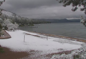
Snow even go to the level of Lake Tahoe (see pic)
And up to a half foot below 7000 ft.
So cold that the temperature at 5000 ft (850 hPa) at Oakland, California tied the record for the date! (the circle shows today's temperature at 5 AM). Impressive, most impressive.
Why is this cold and precipitation, so unusual for this season, hitting California? The reason is that an amazing area of low pressure moved into California (yes, the low that hit us first!). Take a look at the 500 hPa forecast for 2 PM Sunday. Just amazing...you would think it is February.
Will the weather gods relent in sending winter weather to the West Coast? The answer is no. Here is the upper level chart (500 hPa, around 18,000 ft) valid at 11 PM on Thursday. A very long Pacific jet stream (where the lines are close together) is aimed directly at the Northwest. This is a January pattern not a mid-June one.
And with strong flow approaching our region from the west, substantial precipitation will fall north of the CA border. 2-5 inches along the Vancouver Is. coast.
Some folks have been worried about a lack of rain during the past few weeks over western WA....they will soon stop worrying.
I should have known this bout of winter would occur...I put in my tomato plants over the weekend.


CA has a lot of hot and dry to make up for with cool and wet, given that long-term climatic averages move very slowly.
ReplyDeleteWithin the context of a lifetime, one can only say with certainty that weather trends will tend to average out. Changes in the climate mean and variability require consistent science over long periods of time to judge, not personal observation or memory. Unassisted memory is notoriously unreliable to analyze mean shifts and weather trends.
Or as my ancestors (most of them farmers) would say, payback is always a bitch. The further weather goes in one direction means the further it will have to go the other way to get back to the average.
John Marshall, so unsupported observations work for you but not for others. You have an active imagination for sure.
ReplyDeleteWhen did people turn into a-holes on our local meteorology professors private blog? Even here there's no escape! :(
Delete"Will the weather gods relent in sending winter weather to the West Coast? The answer is no."
ReplyDeleteI dunno, the forecast for next week looks pretty hot, for CA at least.
-Douglas
IMHO John Marshall is spot on. The comments are essentially the "eye of the climate debate hurricane"!
ReplyDeleteClimate and weather are frequently confused. We are not having an ice age because of a cold front, nor is global warming, nessesarly the reason for California past drought.
One must look at averages over long periods of time to begin to get a glimpse at changes in climate.
Droughts, flooding and fire are nothing new to California, or much of the west.
Extreams are interesting, but it is the averages that count.
(By the way, it has been weirdly humid at the Admiralty inlet, strange lack of onshore flow.)
Cliff, what do you mean "the answer is no"? Of course it will change- it is just a question of when!
ReplyDeleteBut I do hope that this will not be another 1993. Last time I checked, the prediction was for a warm summer and the 8-14 day was for warmer and drier than average. I sure hope they haven't retracted that.
Cliff--
ReplyDeleteThought you'd be interested in this development leftover from last year's warm blob: http://news.nationalgeographic.com/2017/06/pyrosome-fire-body-bloom-eastern-pacific-warm-water/?utm_source=Facebook&utm_medium=Social&utm_content=link_fb20170613news-pyrosome&utm_campaign=Content&sf88201536=1
Cold Water Blob.
ReplyDeleteCliff and/or others; is there any historical precedent to correlate the abnormally low sea surface temps in northern pacific to the persistence of the gulf of alaska low/cool northwest spring? Or is it a matter of the weather patterns influencing the SST's? ...or a symbiotic relationship? Noticed that SST's have been below average for a while now this winter/spring...
ReplyDeletehttp://www.ospo.noaa.gov/data/sst/anomaly/2017/anomnight.6.12.2017.gif
Ever since the winter storm that made Cliff famous I have a link on my phone directly to this great website.
ReplyDeleteMy friends check the forecast, meh, I have a double barreled shotgun when it comes to nailing the forecast. Thks for the cool maps charts and data rich spreads.