Temperatures will progressively rise during the next few days, with Portland leading Seattle on the way up.
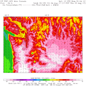
The latest UW model forecast, verifying Thursday at 5 PM, tells a torrid story. Over 104F from Vancouver, WA southward into the Willamette Valley. Over 100F from Olympia and Shelton southward, and 96-100F around Puget Sound country away from the cool Puget Sound. Cooler on the coast and over NW Washington.
This situation is one in which Portland will experience severe warmth. The sea level pressure (solid lines) map for 5 PM Thursday, with surface winds and lower-atmosphere (925 hPa, about 3000 ft) temperatures, show very warm air in the Willamette Valley, with easterly flow over the Oregon Cascades. Easterly flow will be weaker over western WA, resulting in less downslope warming.
Some of the forecast guidance is showing crazy warm temperatures this week. For Seattle (the airport), the National Weather Service GFS MOS (Model Output Statistics), which does a statistical correction to the forecast output, is going for 96F on Wed., 100F on Thursday, and 97F on Friday. I don't remember ever seeing 100F for MOS at Sea-Tac.
And here is the weather channel (weather.com) forecast for Portland. 109F on Thursday...an all time record (and only 107F on Wednesday... tying the record).
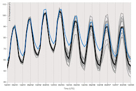
I am a great believer in looking at ensembles (multiple runs of model forecasts) to get an idea of the confidence of the forecast and possible alternatives. Here are the GFS ensembles (called GEFS) of surface air temperature for Seattle and Portland. The ensemble average is the black line, and the high resolution member of the ensemble is blue.
For Seattle, there is a lot of confidence (forecasts are on the same page) that temperatures will get to 94-98F. Amazingly, temperatures only cool a bit for the subsequent days (to the lower 90s), but it is clear than uncertainty increases substantially (more of a spread in the forecasts). We are talking about one of the major sustained heat waves in a long time around here.
Seattle GFS Ensemble
The Portland ensembles get into the low-100s, with the higher resolution deterministic run (blue line) rising to around 105.
Portland GFS Ensemble
Keep in mind that we are already slightly past the time for the century temperature records at Seattle.
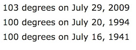
Below are the three days on record with Sea-Tac Airport getting to 100F or more--all are in the second half of July. The sun is starting to weaken as the days shorten, so that is working against the high temperatures a bit.
To get more insight into our chances of high temperatures, here are the record daily temperatures (yellow) and normal highs (red line) at Sea Tac Airport. You can see the peak on July 29th of 103F. There is a slight downward trend of the high temps in early August, with much cooler peaks in late August. Then the peaks go up a bit in early September.
I bet I can explain that...the sun is weakening, but we get more strong offshore flow days, which can cause warming by the compression of air sinking over the western slopes of the Cascades.
My biggest surprise today was seeing some unsold fans in my local supermarket. I bet they will be gone in two days. Stay cool.


I love it. We live in a cold dank place for much of the year. To me this is like snow in Phoenix. A rare treat.
ReplyDeleteJeffB nailed it.
ReplyDeleteGood that Rod and JeffB love it. Others will be suffering. Party on.
ReplyDeleteRipe tomatoes for a change!
ReplyDeleteHeaded to the Colorado Rockies Friday afternoon... really sorry it's not easy to move my flight to Thursday!
ReplyDeleteThe sun was red as a cherry tomato this morning, which is typical of forest fire smoke, and now there's like a haze all over Whatcom county, I have a hunch this is going to affect these predictable temperatures as the sun is mostly blocked out
ReplyDeleteWhat's with this Haze/smoke ??
@Unknown, the smoke is probably coming down from the fires in BC.
ReplyDeleteIf you are curious about the haze and smoke check out the following link (it was shared by Cliff a year or two ago). It shows predicted smoke levels in the PNW and you can see the hot spots that are all of the fires.
ReplyDeletehttp://www.lar.wsu.edu/airpact/gmap/ap5/ap5smoke.html
Cliff, why is it so hazy/smoky in South Snohomish county today?
ReplyDeletePossibly in part due to a car fire that spread into a grass fire around exit 189? It was a huge plume.
DeleteWhat about the reduction in visibility Tuesday afternoon? Inversion, pollution records?
ReplyDeleteWill the haze significantly lower the predicted high temps of this week?
ReplyDeletejohn k:
ReplyDeleteit's summer. this is what summer does. it gets nice, sunny, and hot. I'm simply amazed that all the cloud worshiping vampires around here are surprised when summer does what it's supposed to do.
I figure we get as many days over 85 as we do under 35. I love both, it shakes things up a bit. Will the haze increase or decrease temperatures?
ReplyDeleteJohn K - they were not complaining. They were saying they enjoyed the heat wave.
ReplyDelete