Today, accompanied by glorious heat and sun, was probably the last day above 80F until next spring.
Fortunately, our last warm day was announced by something very special: an amazing auroral display last night.
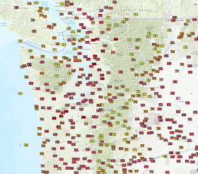
First, the temperatures. Today's high temperatures got into the mid to upper 80s around much of western Washington (see map). The light reds are 80F and above, dark reds 90 plus. Sea-Tac got to 86F. Amazing.
A number of locations around the area (like Sea Tac) achieved their record high temperature for the date, with high temperatures 15-20F above normal.
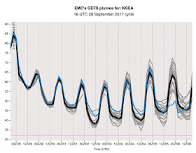
Why so warm? Warm air associated with a ridge of high pressure and moderate offshore (easterly) flow, which kept the cool ocean air offshore (see winds and temperatures above Sea Tac below). Easterly flow also caused warming as air subsided over the western slopes of the Cascades and Olympics.
The situation is about to change radically, and a front is poised to move in on Friday (see satellite image a 8 PM). And models promise strong onshore flow and a series of weather disturbances. You won't have to water your lawn or bushes anymore.
Now why do I think our 80F days are over? First, virtually all the ensemble forecasting systems, which run forecasts many times to get at uncertainties, shows a cool down over the next 8 days, with temperatures not getting much out of the 60s. The temperatures predicted at Seattle from the NOAA/NWS GFS model illustrates this below.
And after that, it is simply too late to get very warm, with the sun weakening and the nights getting longer. To illustrate, this plot shows the record highs at Sea-Tac (yellow), based on daily records. In September, the record highs can get to around 90F, but the bottom drops out during October, and after around October 12th, Sea Tac never has got to 80F. Depressing, but true.
But our depressing future cool down is at least made more palatable by the stunning aurora of last night. Here is an image provided by Greg Johnson of Skunk Bay Weather, on the north side of the Kitsap Peninsula. A video link is here.


Stunning video!!! Thanks!!
ReplyDeleteThose Northern Lights are almost like the glorious, and troubling, summer of 2017 saying goodbye. Let us hope we are all still here to welcome the summer of 2018.
ReplyDeleteBring it. I personally dislike warm weather, and I'm looking forward to that annual rite of passage that marks the true beginning of autumn here: People whining about the cool, wet weather. I hope they have a lot to complain about for many months to come :-)
ReplyDelete"Today, accompanied by glorious heat and sun, was probably the last day above 80F until next spring."
ReplyDeleteGood.. I'm more than ready for our cooler wet weather. I hate dry and hot.
Amen. If I wanted hot dry weather I would have stayed in California. :)
DeleteWow, I should have been paying more attention. I have never seen one that was any more than a dim glow on the horizon that might be mistaken for neon lights on some building in the distance.
ReplyDeleteRats! I should have looked for the aurora, but I had no idea it was coming. Instead we stayed inside and watched TV. I have only seen the aurora a few times, only twice vividly, and only once in color.
ReplyDeleteAnd then, bang summer was over. https://www.facebook.com/photo.php?fbid=10155823797786584&set=gm.10155883130393010&type=3&theater
ReplyDeleteCool breeze and mist!! Bring it on
ReplyDeleteAnd where else would we be, Kelly?
ReplyDelete