The water vapor satellite imagery at 5 PM yesterday said it all....a huge plume of moisture stretching back thousands of miles into the central Pacific. (this type of satellite imagery highlights water vapor content in the middle to upper troposphere).
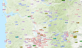
The 24-h precipitation totals ending 7 AM Sunday were impressive (see image, click on it to enlarge), with over four inches on the SW side of the Olympics and the western slopes of the Cascades and 1-2 inches over the south Sound lowlands. Look closely and you will see only about 1/4 inch fell around Port Townsend on the NE side of the Olympic Peninsula...the rain shadow in action.
Even heavier rain fell over the coast mountains and Cascades of western Oregon, with several locations receiving over 6 inches in that 24-h period. Roughly 2 inches in Portland.
If you really want to appreciate the rainshadow, here is the 24-hour precipitation total from Seattle RainWatch, which calibrates radar totals using rain gauges. .1-.2 inches over southern Whidbey Island, with 4-5 inches southeast of Puget Sound over the western slopes of the Cascades.
To illustrate, the Snoqualme River, near the town of Snoqualmie, is now at moderate flood stage. Fortunately, it should decline rapidly today.
As a result of the westerly winds aloft, Seattle and much of Puget Sound is in the rain shadow of the Olympic Mountains today, with lots of sun. In contrast, the western slopes of the Cascades and Olympics are getting hit with moderate showers (see radar below).
A nice day around Seattle and Portland today, even with some moist, unstable flow reaching our coast. You get to appreciate the rain shadows around here.


Only .25 in of rain yesterday in Langley, WA on Whidbey Island. Most of that fell after dinner and overnight. Those rain shadows certainly are amazing.
ReplyDeleteWhy is it that Tacoma never sees such dramatic weather? Is it where we are below the Sound?
ReplyDeleteIt has to do with where it’s situated in relation to the Olympics. It’s pretty amazing how different Tacoma can be in comparison to Seattle in terms of rain!
DeleteThis last storm was a bust near Sequim, but we at least got 1.5" out of the last week's collection of storms. Barely enough to keep from irrigating my trees and bushes and to perk up the grass. Things were REALLY dry.
ReplyDeleteThis was pretty profound rain shadow event, and we were at the extreme western edge of this one. Always wishing for a little more rain to make things lush without turning on the taps, but living in the PNW desert has its pros and cons.
Although there is always a brief period in February when I say, "OK, that's enough."
But lounging on my deck in the sunshine this last week while watching the very impressive storm clouds pass by on all sides (I'm on the top of a hill) has its own pleasures. Thankfully it did rain at night, which seems to be a feature of the rain shadow. Night rain, days dry.