The next 48-hr will be stunning in a number of ways: very heavy precipitation in the mountains, river flooding, and temperatures that will reach record levels.
The forecast for today at 1 PM, shows the story, a strong plume of moisture from the south that is heading directly into the Northwest (blue and white colors indicate the largest values).
The moisture channel satellite image from last night at 9:30 PM shows an amazing plume of water vapor heading directly from the tropics. It has our name on it.
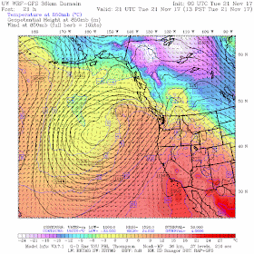
Accompanying this plume of tropical moisture will be near-tropical warmth, something illustrated by a forecast chart for 1 PM Tuesday at the 850 hPa (about 5000 ft) level. Red/orange are warm temperatures, driven northward by powerful southwesterly flow aloft
Or we could look at the forecast temperatures (red lines, °C), winds, and humidity (shading) over Seattle (see below). Time increases to the left and the heights are in pressure (700 hPa is 10,000 ft). The blue line is the freezing (0°C) level.
Unbelievable...the freezing level rises about 10,000 ft. This means rain everywhere...even over the high terrain of the Cascades. The atmosphere is very moist (green colors), with strong southwesterly winds aloft.
Now let me show you the forecast precipitation with 24 hour totals.
Ending 4 PM Tuesday...heavy rain in the mountains, with 2-5 inches in the Olympics.
Even more the next 24h (ending Wed. at 4 PM)
Just as much the next 24 h. Yikes.
Add them all together for the 72h total ending 4 PM Turkey Day. Much of the mountains get 5-10 inches, with a few places in the Olympics getting more. Expect flooding on a number of rivers. And yes, our snow will do some serious melting.
But what really will be amazing will be the temperatures. Here are the forecasts from the National Weather Service SREF ensemble for Seattle...many of the members will reach into the LOWER 60s on Wednesday....probably breaking the daily record.
Well...this is climatologically the wettest weak of the year!


This years bounty of leaves keeps falling into my gutters and storm drains. I do hope my last clean out was sufficient for the wet to come.
ReplyDeleteRaining top to bottom now at Stevens and Crystal. Stevens closed down Tues-Thurs, Crystal back to very limited operations. Not sweet.
ReplyDeleteNo escape in BC, even the Rocky Mountain Resorts are gonna hit by this.
ReplyDeleteI should have cleaned those gutters.
ReplyDeleteWell, at least the dams will be full after all of this - good news to be sure.
ReplyDeleteThe reference to "warm rain" for melting snow cover mentioned earlier is not true. You do the math! Cooling one gram of liquid water say at 5 degrees Celsius to zero C only yields 5 calories. Latent heat of melting is 80 cal/g and latent heat of evaporation or condensation is about 600 cal/g. The latent heat of condensation of water vapor into snow cover thus is a much more potent source of melting. So gaseous water vapor evaporated near Hawaii and condensed onto the cold ice surface over the Olympic Range exhibits the advection of energy by H2O along the atmospheric river. Cheers. Hans Rosendal
ReplyDeletePlease, for the love of God, do not let this be a repeat of 2014-15. We had these atmospheric rivers with snotty wettness, followed by cold and clear, then back to warm and snotty. Our ski industry needs a good winter cycle!
ReplyDeleteOn a trivial note, the rain shadow of the Olympics stands out like a windsock telling you what direction the system came from.
ReplyDeleteNot sure where you were, Russell, but last season was a great winter cycle for our ski industry.
ReplyDelete