You know what I mean: no big windstorms, crippling snowstorms, heavy rain or extensive flooding. That kind of thing.
One way to see this is to plot the (sustained) winds at Sea-Tac Airport for the last 12 weeks (below). One decent event in mid-November (sustained winds reaching 32 knots), and pablum after that. Boring.

For those of you who like weather action, things will improve late tomorrow ans Saturday, but even the upcoming event will only be a modest blow. But we must take what meteorological scraps are offered to us by the weather gods.
Let me start by showing you the pressure forecasts for the next day or so. The forecast for 10 PM Friday night looks promising, with a modest low center (a Pacific cyclone of 997 hPa) off our coast. A strong pressure gradient on the Oregon coast....the will be ground zero for strong winds tomorrow evening.

By 8 AM Saturday, the low center will be making landfall on south/central Vancouver Island, with lots of pressure gradient and winds along the Washington Coast.


Want to see the wind forecasts? At 10 PM tomorrow, sustained winds as high as 45 knots are predicted about the Oregon coast.

And three hours later, strong winds will hit the Washington coast, with very strong easterlies in the western Strait of Juan de Fuca (see image). Essentially, the air is accelerating towards the offshore low within the Strait.

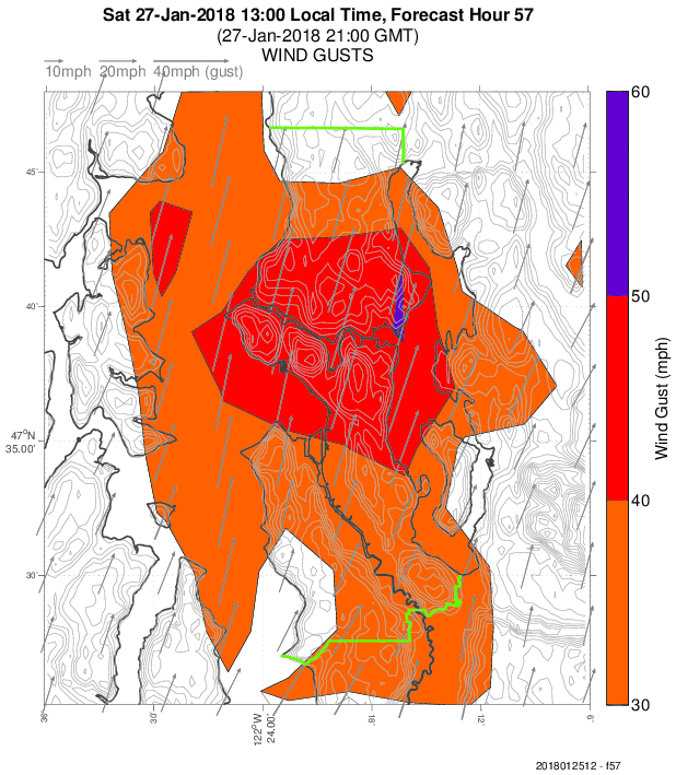
The strongest winds will hit central Puget Sound around 1 PM Saturday, something suggested by the UW WRF model forecast (see below), with gusts of 40-50 mph predicted. (Graphic from Seattle WindWatch).
OK...this is one forecast. Perhaps I should not get too excited... a small error in location of the low will have a major impact, and, in fact, the National Weather Service SREF ensemble of many forecasts has a huge amount of variation among the solutions of their forecast models, from 4 to 26 knot sustained winds during mid-day Saturday over Seattle (see below). So there is considerable uncertainty still in this forecast.

Anyway, we can watch the models tomorrow to see if they stay with this storm.
The weather also has been boring because there's been no major Arctic air outbreaks or winter storms, either.Although the models are just now starting to tease us with a hint that such an event could happen around Feb 5th.It's too far out to put much stock in it,but it bears watching....
ReplyDeleteThis winter has been BORING! Full agreement. A little snow tease in early November...and then nothing.
ReplyDeleteWhat are the chances of a decent snowstorm before spring?
ReplyDeleteWhat I am tired of is the repeated precipitation - temperature Yo-Yo of this late fall/winter. Here we go again - rain with a projected high of 55F on this Sunday, with a bunch of low level snow to melt. Bad of skiers, bad for winter steelhead fisher-people....yuk!
ReplyDeleteIt's been a great week for mountain snow.
ReplyDeleteYes, boring and clammy and cold. I'll take some variation! Wind always makes things a bit more exciting.
ReplyDeleteIt snowed on Christmas Eve and Christmas. Definitely not boring around these parts... particularly for anyone with children or grandchildren waking up on Christmas morning to snow!
ReplyDeletehttp://komonews.com/weather/scotts-weather-blog/snow-over-christmas-holiday-managed-feat-never-before-done-in-seattle
"With 1.6 inches on Dec. 24 and another 1.0" of snowfall on Dec. 25, it was the first time in Seattle recorded history (back to 1894) the city had experienced at least 1 inch of snowfall on both dates."
Wonderful!
We got close to 6 inches in Wedgwood but that seems to have been localized.
ReplyDeleteCouple more weeks and we will be cutting grass and pulling dandelions. So unless there is some sort of coup de grâce up this "La Nina's" sleeve, we will just have to take lowland "Meh" in exchange for a pretty good ski season/decent snow pack to get us through another obnoxious summer. We have probably been expecting a bit too much as far as weather excitement since the so called neutral years yield more diverse weather events compared to "El" and "La"?
ReplyDeleteSummer will give us plenty to talk about, probably. There is a much greater chance of a massive high pressure triple digit heatwave and wildfire smoke fest than an arctic outbreak these days. If anyone wants to dig up a chart of average ocean surface temperatures for the past century or even 30 years...well, if it was a representation of your stock portfolio you would undeniably be happy! You would get to retire and not even have to move to Florida to enjoy warm weather in retirement. Living next to an ocean that is becoming ever warmer is not going to deliver much in the cold weather department. Even the Arctic might be saying "Meh" these days, if it were not for the issues of melting permafrost destroying villages etc.
"Here we go again - rain with a projected high of 55F on this Sunday, with a bunch of low level snow to melt. Bad of skiers, bad for winter steelhead fisher-people....yuk!"
ReplyDeleteI don't understand this. The skiing has been great - and that is at Snoqualmie Pass, the lowest major ski area in the state - this entire week. Here is their snow comment today: "We've received 27" of new snow at Summit West in the last 48 hours with 18" falling since yesterday! Our storm total 67" at West and 77" for the base of Alpental"
That's right: 6 feet of snow in 1 week. And that is not an exaggeration, WSDOT is reporting 5.5 feet at the pass itself.
The current 7-day forecast for the central Cascades shows one small timeframe - Sun/Mon - with a freezing level at 5-6k feet - and then it immediately goes back to 2,500 or less for the next 6 days in a row. With snow projected the entire time. The skiing this week is going to be fantastic - anywhere in the state.
So basically there will be a 2 week period - with a massive snow dump and great winter skiing conditions - with one 36 hr period where it might - might - rain in the passes. And you choose to focus on that 36-hour period? I don't get it.
And also - what makes this pattern abnormal? This is completely typical of January weather in the Cascades.
Sunsnow,
ReplyDeleteliving here my whole life and I am in 100% agreement with you.
sunsnow,
ReplyDeleteLiving here my whole life (over 50 years ) and I am in 100% agreement with you.
you said it boring and the NWS forecast , as you indicated might happend was a bust again!
ReplyDeleteYou are DA MAN!
Keep it up Cliff
Baker has received ~150 inches in the past 10 days...
ReplyDeletehttp://images.intellicast.com/WxImages/CustomGraphic/scover.gif
ReplyDeletehttps://dsx.weather.com/util/image/map/WEB_Snow_Cover_1280x720.jpg?v=ap&w=1280&h=720&api=7db9fe61-7414-47b5-9871-e17d87b8b6a0
Overall, the snow pack for the United States is fairly sparse other than in the highest mountains. This is what we all wished for, right?
Lived here 69 years. I remember the Columbus day storm. I was terrified. Darn near blew the windows out in our front room. No power for days. Now we live in a forest. Lots of huge trees (left there on purpose by us - keeps soaking up water and moderating temperatures); however neighbors keep cutting down trees exposing ours to the full force of wind. Roofs damaged twice here. Car damaged. I'll take boring, thank you very much.
ReplyDeleteNothing is as boring as the weather has been in Southern California this dry winter. However 93 F in Lake Forest in January can get pretty interesting.
ReplyDelete