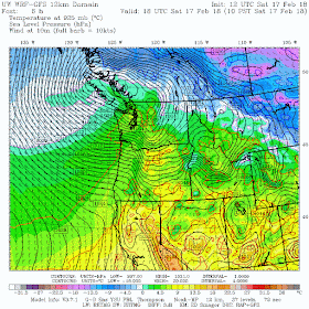
The reason? A low pressure center is moving eastward to the north of Puget Sound, resulting in a large pressure gradient...and thus strong winds.
A strong front is associated with the low, and with powerful westerly winds aloft (some reaching 70-100 mph!), massive snow amounts are falling in the Cascades, with the big trouble in the passes (chains required and delays in Snoqualmie).
But this active weather is just a "warm up" for what is about to happen. (In fact, just the opposite of a warm up!).
Tonight and tomorrow morning, modified arctic air is going to push in, with a huge pressure gradient down the Fraser River Valley, a conduit between the cold, high pressure in the BC interior and the warmer, lower pressure conditions in western Washington. Very strong winds will exit the Fraser Valley producing gale-forced flow from north of Bellingham, across the San Juans, and towards the Olympic Peninsula (see forecast gusts at 8 AM tomorrow). Wow.
The latest forecast model output suggests snow on the windward side of the Olympics and light snow even over Seattle as the leading edge of the cold northerlies push southward during the morning hours. For Puget Sound residents, LIGHT is the operative word.
Here is the forecast 24-h snowfall (not accumulation) ending 4 PM Sunday. Lots in the Cascades and less than an inch over parts of Puget Sound, with perhaps 1-2 inches in places south of Seattle. More snow over the San Juans.
But this is only one model forecast. We should turn to ensembles (running many forecasts to judge our confidence in the snow prediction). Here is a "plume diagram" showing 15 accumulated snow forecasts for Sea-Tac airport (time on the x axis and snow total on the y axis). A LOT of variation and thus uncertainty, with the ensemble mean being about half an inch. The heaviest is 1.4 inches.
Time to go outside and disconnect all hoses. This will be coldest air we have had in over a year.


Right now Hy 2 is closed for avalanche control west of Stevens Pass. But at home in my Seattle neighborhood it is sunny and 51 F. Wild weather.
ReplyDeleteIt was a beautiful day for a hike up Mt. Walker (near Quilcene, on the peninsula). Sunny and no wind!
ReplyDeleteRainshadow...
ReplyDeleteCliff, I have read your blog for several years to help me plan outdoor adventures...I have really been fascinated by the “snow -thunder storms” the last two days in the Spokane area. FYI . Thanks for your insight and help with planning outdoor pursuits ! The skiing today at Schwietzer was incredible- very windy 45mph with 3-5” of blowing snow !
ReplyDeleteMission Ridge had 100+mph gusts all afternoon Saturday, including one of 119mph at 4pm.
ReplyDeleteWe have 12!!!!!!! inches of snow at Lake Goodwin, about 7 miles west of Arlington, and about 500ft in elevation. Can't believe it. Still snowing. Can't figure out how to post a pic, cuz I would love to share. Good thing I LOVE snow.
ReplyDelete5 inches at Flying Bear Farm 262 ft elev. in Langley on Whidbey island. Most we've had here in years. The convergence zone hammered us, plus the radar indicated some localized upslope on the upland above Saratoga Passage that probably added an inch or two. The local NWS office forecast discussion hit this snow event on the nose.
ReplyDeletePicked up a solid 4" here just NW of Lake Tapps in Lakeland Hills. Amazing how a heavy band of snow set up right over us most of the morning and early afternoon. Now nice North wind and temps dropping into the upper 20's! Finally La Nina shows her stuff... Not bad for Feb. 18th!
ReplyDeleteGot about 6" on the 1000' summit of Bell Hill near Sequim. Nice upslope after the northerlies began (they were later than forecast). Didn't blow too much, but it really snowed in mid-morning.
ReplyDeleteAlso nice that the cold will lock it all in and keep it around in the sunshine early this week.
Just glad I don't have to go anywhere.
Also here in Lake Tapps with 4+ accumulated-did-not-go-away-like-it-was-supposed-to inches of snow.
ReplyDeleteLooks like Portland beat Seattle on the snow scorecard again. :(
ReplyDeleteThe I 90 Westbound bridge was closed yesterday due to whitecaps on Lake Washington.
ReplyDeleteIt was that second blow, the wind out of the west that did the most to us in Federal Way. Lost a pretty good sized hemlock on the west side of the property. The road outside our house sits in a cut that goes down to the sound, so when the west wind blows we get a double impact.
ReplyDelete