With 70s even along the coast (made possible by warm offshore winds). Warmer in Seattle than in the Tri-Cities.
Several locations beat daily records ( Sea-Tac, Olympia, Quillayture, Hoquiam, Bellingham)...and some by a large margin ( Seattle beat the old record by 5F!, Bellingham by 6F)
The 73F today at Sea Tac is the warmest at that location since late last September, as shown by this plot. And 20F above normal.
Getting to 73F at Sea-Tac early in March is quite unusual. It is the earliest day on record that the temperature has risen above 70F at the airport. Now that should impress someone. It impresses me.
The temperature spiked today for a reason: the air was relatively warm due to southerly flow aloft and then we had strong easterly (from the east) flow that supercharged the temperatures by adding strong compressional warming as the air sank down the western slopes of the Cascades and coastal mountains. Plus, few clouds to get into the way.
Here is a plot of wind direction at Sea-Tac Airport for the last 12-h....easterly flow dominated, and some of the winds were quite strong (15-25 mph gusts)
Easterly flow is a relatively unusual direction in central Puget Sound, as shown the the wind rose for March at Sea-Tac airport (see below). To construct this chart one needs a database of March wind speeds and directions at the location. The plot is a polar plot showing direction (with north at the top, south at the bottom, etc.) The frequency of winds from any direction is indicated by the length of the "rose petals." And the relative frequency of various wind speed ranges is shown by the colors. So winds from the south to southwest are the most probable based on the climatology at Sea-Tac. Easterlies are rare.
The easterlies were associated with a strong offshore pressure gradient (higher pressure inland and lower pressure offshore), connected with a very slow-moving front offshore.
The warm temperatures in our area were well timed, considering today was National Nap Day (I kid you not). But rain and cooler temperatures will move into tomorrow.
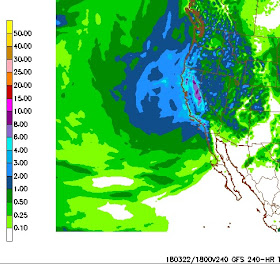
But something else unusual is about to happen. California is going to be inundated with heavy precipitation, much more that is typical of March. Here is the latest model prediction (NWS GFS model) of accumulated precipitation for the next 10 days. The entire state will get plenty of precipitation, with up to 10 inches in the Sierra Nevada.
What about the vaunted European Center model for the same period? Up to 9 inches of precipitable water in the Sierra, and 2-4 inches over much of the northern part of the State.
The operators of CA reservoirs and dams will have to watch the water levels...they are going to rise substantially during the next week or so. And perhaps this event will quiet the drought talk for CA this summer.


I have to laugh when weathermen, or meteorologists, start off with "as promised". It's got to feel really great to be able to make predictions that come true. It didn't use to happen so much 30 or 40 years ago....
ReplyDeleteWhere did this major wind storm we're having right now come from?
ReplyDeleteI'm surprised that yesterday was the earliest date it has gotten above 70 degrees at the airport. Seems to me that there have been several days that have gotten above 70 degrees in early March and even a 74 degree record on February 29, 1968, a record for that month.
ReplyDeleteCliff - curious about what counts as a daily "low" and how the 24 hour period is marked off. It would seem that the afternoon/evening temps on 3/13 after the rain started would be more appropriately called the "low". Appreciate your clarification.
ReplyDelete