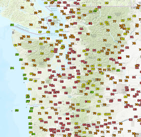
It was wonderful while it lasted. Away from the Pacific Ocean, today was the warmest since last September, with some locations experiencing the mid to upper 80s.
Here are the max temperatures today around the region (click to expand). Around 80F near Puget Sound but zooming up to the upper 80s along the foothills of the Cascades. But the most amazing contrasts were near the coast...with mid-50s near the water but upper 80s twenty miles away towards the east.
During the day, clouds and southerly winds pushed up the coast--a totally typical pattern with what we call an onshore or marine push. Here are the visible satellite photos at 9 AM, 2 PM, and 6 PM. You could see the inundation of the coast by cool, stratus-filled air.
The cool air was held at bay by offshore (easterly) flow, something illustrated by the winds above Seattle during the past 24-h (see below). Time increases to the left and the y-axis is height. Wind barbs (blue) and temperatures (red) are shown. You will notice that the easterly wind in the lower atmosphere are weakening and they will soon turn westerly. The marine air, associated with higher pressure, wants to surge inland.
In fact, the plot of winds and temperatures at 8 PM shows that cool, westerly flow from off the Pacific has made it to Shelton and the south Sound and also in the Strait of Juan de Fuca. Our warmth will be gone by daybreak as cool marine air pushes in, accompanied by low clouds.
Coastal drizzle will occur tomorrow and showers should reach the interior by tomorrow evening.


These things are wonderful for people that like them, or even just like them for a change. Some people don't have allergies, why do you think everybody is like you? There are those of us who have allergies, yet don't whine about it online.
ReplyDeletePersonally, I didn't enjoy those warm days, but I don't see the point in making a comment about that being a bad choice of words on his personal blog!
It never ceases to amaze how some people believe they are the center of everything :)