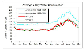
Normal has been good for us, giving relief to our plants, restoring water to the surface soil layers, and radically reducing the water usage in urban areas such as Seattle (see below).
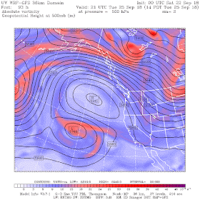
The occasional precipitation has been associated with transient upper-level troughs that have moved through the region, such as one moving across the Northwest this morning (see upper level, 500-hPa, ap for 5 AM this AM)
But this week something interesting is going to happen: a very stable REX BLOCK will develop over the eastern Pacific, shutting off precipitation, leaving us with lots of sun, dry conditions, and moderate temperatures.
It will be wonderful.
So what is a Rex Block? It is a configuration of the atmosphere where the upper level circulation has a ridge of high pressure (or heights) north of a trough of lower pressure/heights. Here is a schematic of such a situation.
A Rex Block is a very stable atmospheric configuration, with the ridge and trough reinforcing each other, keeping the flow pattern in place (for reasons I talk about in my graduate synoptic/dynamics class, but won't go into here).
The ridge/high part produces descending motion and fine weather, particularly on its eastern side. Storms are sent far northward--in the example shown, well into Alaska where they belong.
The Rex Block has nothing to do with kings or dinosaurs, but with a meteorologist named D. F. Rex, who wrote a seminal paper on this features way back in 1950 (see below).
Rex, D. F. (1950). "Blocking Action in the Middle Troposphere and its Effect upon Regional Climate". Tellus. 2 (4): 275–301.
Now that you are Rex-trained, lets look at the upper-level forecasts for this week.
11 PM on Sunday? Rex is here! Huge ridge of high pressure/heights over the northeast Pacific, with a low underneath.
2 PM on Tuesday....classic Rex!
5 AM on Thursday. A Rex fiesta.
The REX block shifts westward on Friday (see below), allowing a trough to move southward over us late Friday night. Some showers and cooling if it happens.
Will the REX block reestablish itself? Stay tuned.


I see that NOAA climate folks are predicting a mild winter for the PNW, with precip perhaps drier than usual as well. I guess that starts now with the Rex block.
ReplyDeletePart of me says "Hooray!"
However, my summer-stressed trees may have another opinion.
Their prediction also says the Midwest is really in for it. Cold and snowy. I'm presuming from past discussions that a blocking high off our coast pushes weather up so it comes barreling down from the far frozen north into upper Plains and Midwest. I'm sure we'll soon see references from the Weather Channel about winter Polar Vortexes or whatever label they like this year.
Meanwhile, we'll be smug, snug and happy in Western WA.
Predictions of a mild and dry winter here are no doubt due to the El Nino although the last El Nino we had a wetter than normal winter. The last few winters have actually been wetter and stormier than normal or just normal. It's been years now since we had a drier than normal winter (2013-2014 was and 2014-2015 was feast or famine either big ridge or atmospheric river). It wouldn't be good if we end up having conditions similar to 2000-2001 or 2013-2014. Those were the "ridgiest" winters I can remember, almost drought like, although neither had El Nino conditions.
DeleteWe're really getting rained-on right now (3:30 PM) in the hills east of Arlington.
ReplyDeleteYay! I can just hear all the plants & trees just licking their lips.
Good thing we've had showery weather before this so no dust-dry ground (that basically repels water). Hoping most of this soaks in where it lands. The aquifers need it. We need it. All the wells need it. Looks like the need for water rationing has passed.
It'll be nice if we do get a break as predicted by NOAA. But I'll be happy when REX leaves Fri. Fair is fair, and we need a more normal wet winter. And I'm speaking from one of the real wet spots in W WA ~ used to be 80 - 100 inches per year. A winter snorkeling spot. Went into withdrawal with the previous long dry spell.
I got 2 inches of rain here in the convergence (Bothell-Mill Creek line) in the last 28 hours.
ReplyDeleteSue Willard, can you provide some statistics to back up "we need a more normal wet winter"?
ReplyDeleteOur (WA) winters - including 2015 - have either been at average or above average in precip for multiple years in a row, including this most recent 17-18 water year (which will once again finish above normal - currently at 106% of normal for the water year and that includes this summer).
If you live in an area where you had a "need for water rationing", in a year where we are at or above average in precip (following multiple years of the same), then I would suggest it is far more likely there are problems with your local provider/system that have nothing to do with precip.
Here is Cliff on it earlier this year, please note the WA avg precip graph and trend - http://cliffmass.blogspot.com/2018/04/west-coast-precipitation-trends.html
Cliff. La Nina or El Nino or La Nada? Skiing decisions coming up! I need to know!
ReplyDeleteCliff,
ReplyDeleteHow long lasting are these REX Block situations? Are we looking at a similar pattern setup as winter 14-15?