Earlier this fall, the National Weather Service was going for a dry autumn for our region (see below). That is NOT going to happen.
The last 72-h has been wet enough, with 4-5 inches along the western slopes of the Cascades, 3-4 inches in the Olympics and 1-2 inches over Puget Sound, which is rainshadowed by the Olympics, Eastern Washington had much less of course (click on image below to enlarge).
But hold on to your hats....Pacific moisture has big plans for us. Plumes of moisture will move around a region of high pressure off of California and then produce substantial precipitation as is it forced to rise by our region terrain.
You know that name of these currents of high moisture values: atmospheric rivers.
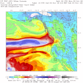
Below I will show you a series of forecast column-integrated water vapor, basically summing up the water vapor in a vertical column. Red is high, white and blue are very high.
The first one hits on Wednesday morning, with moderately high values moving in from the west.
Thursday night and Friday morning, another weak one.
But Saturday morning is another thing...much stronger and heading directly from the west.
Now moisture is important, but so is wind. A strong wind pushes more moisture up the terrain, producing more precipitation. And, of course, we can quantify this, using something called IVT: Integrated Vapor Transport. Throw that term around and you will either impress your friends or be classified as a hopeless nerd.
Well, in any case, here is the IVT for Saturday morning. OMG. This is serious.
With lots of moisture pushing westward, the 48h precipitation ending 5 AM Monday is substantial, with as much as 5-10 inches in the Cascades.
But if you really want to be impressed, here is the total precipitation forecast for the next 7 days. Wow. Most of the higher terrain gets 5-10 inches, with several inches in the lowlands. Because the winds are from the west, the interior lowland (e.g., Puget Sound) will be partially rainshadowed by the Olympics.
Rivers will rise, reservoirs will fill. And unfortunately, the long-term forecast will prove unskillful.


Thanks,
ReplyDeleteSo can we expect mostly snow over higher elevations or is rain gonna crash this party?
Has anyone studied the idea that long term localized weather may not be possible to predict?
ReplyDeleteToo many factors Changing with each other..
I predict that if the technology ever comes to make these kinds of calculations, it will also be able to predict long term human behavior. Which is a bit spooky..
And leaves will fall. Hope we get some dry spells to try and collect them.
ReplyDeleteI am traveling East on I-90 on Friday. Does this mean snow over the pass or just a lot of rain? I do have brand new tires!
ReplyDeleteChris, according to many of our "leaders" in the AI field, we're already there. Welcome to Huxley's brave new world.
ReplyDeleteI assume temperatures will remain mild consistent to a pineapple express if that is what we are facing.
ReplyDeleteI can predict - with certainty - that next September/October there will be pervasive, almost hysterical predictions for a dry winter, just like we were hearing a few weeks ago. There will be talk of a "new normal"; that "the climate deck may be stacked against us"; that we must adapt to "the lasting impacts of drought..."
ReplyDeleteJust like last year, and the year before, and the year before... all of these drought predictions unbelievably wrong... going on for years (actually decades) now.
Why is that?
Btw - our reservoirs just took a sizable inflow over the weekend, but we will be thankful for every square foot of space in those reservoirs if this 7-day plays out. Flooding is a concern now. Now that is real.
yes it has been studied. A lot.
ReplyDeleteLooks like the GFS scaled back unfortunately. I'm sure it will bounce back though.
ReplyDeleteThe true bounty of the NW is here. Whitewater boaters have been waiting all summer for the rains. We have a few epic river waves that only come into shape with a huge rain event. Cant wait for the weekend! All kayakers love it when Cliff starts talken atmospheric rivers..... More rain please!
ReplyDeleteLooking at the Tuesday morning forecast for the weekend, it seems they are now discounting this big rain event. In fact, for my area (near Sequim), the Sunday forecast looks pretty dry (18% POP) with the previous day (Saturday) only around 50% POP.
ReplyDeleteI'm assuming the atmospheric river is now forecast to come in further south than originally modeled.
But... still far enough out that things could change, but it appears that Tuesday night through Fri morning are the wet periods now, with several gaps in even that rain. Halloweeners are going to get wet.
Why the general public is ignoring environmentalists, part 2,003 -
ReplyDeletehttps://www.dailywire.com/news/37735/environmentalists-save-world-dump-your-pets-emily-zanotti
They've become unhinged, and my earlier contention that they've morphed into hating humanity in general and everything that goes along with it remains unabated.
Hm, well we are certainly forecasting a barrage of precip from today through the weekend in Bc. Mixed bag though as it looks to be half snow n half rain in the mountains followed by a cool drying trend.
ReplyDelete