_________________________
Some of us may have been feeling safe here in the Northwest, as extraordinary cold has hit the Midwest and the eastern U.S..
Soon we will be feeling the sting of cold temperatures and even the potential for lowland snow.
The coldest air of the winter will reach our area on Sunday, and Monday's temperatures in western WA may not get above freezing. Savage cold and wind will hit the Bellingham area. Eastern WA will make an icebox seem warm. The mountains will get plenty of snow and some of the lowlands we be whitened.
You might want to get prepared on Saturday--winterize your home (e.g., remove hoses from faucets), gas up your car, make sure the antifreeze is up to snuff, and move your pets inside after Sunday AM. Our region will have to pay extra attention to making sure our homeless folks are in warm places.
We are close enough in time that I have confidence that the upcoming cold wave will be a reality, so let me start by showing you the forecast of the UW WRF modeling system. The following maps show sea-level pressure (solid lines) and temperature around 2500 ft (colors). Yellow and orange are relative warm. White and light blue indicate just cold enough to snow to sea level. Dark blue and purple are much colder and "snow friendly." You don't want to know about white.
Today at 4 PM, moderate temperatures are over most of the domain, with a low center and front offshore. It will rain tonight and Friday.
Fast forwarding to Saturday at 4 PM, very cold air is moving southward into British Columbia. Note the large pressure gradient at the leading edge of the cold air. We often call that the "Arctic Front."
By 4 PM Sunday, the cold air has reached Washington State and there is a large pressure difference north of Bellingham, which will drive cold, gusty flow into NW Washington. Yes...cold enough to snow.
By 4 PM Monday, the entire NW is in the freezer. But keep in mind, this is not the primo cold air. The Cascades and Rockies will protect us from that. (We get "modified" Arctic air). The really cold stuff will move southward into eastern Montana (see below).
How confident are we that the cold air will reach us?
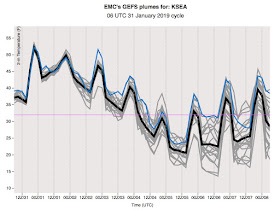
To evaluate that let's take a look at the National Weather Service ensemble output for Seattle's surface temperature (the temperatures of many model runs are shown, each slightly different in how they start). They are all going for a major cool-down, with most showing that Monday will barely get to freezing as the day-time high. It will be cold bike-ride for me to work that day.
What about snow? The pattern that is being forecast is not a huge snow producer over the lowlands, but the models are suggesting that certain lowland areas will get snow.
I will talk about this more in a future blog, but here is the forecast 24-h snowfall ending at 4 PM Sunday. You will notice a band of light snow extending across Everett and Snohomish county. That is from the convergence of strong, cold flow coming out of the Fraser River Valley hitting southerly flow coming up Puget Sound.
The next 24 hr snowfall is similar, with NW Washington getting snow, with higher amounts near Port Angeles and Sequim as the cold air is forced to rise over the Olympics. Snow over eastern WA and NW Oregon.


It looks like the first half of February will have below normal temps,due to our persistent ridge retrograding further offshore.Interesting La Nina- like pattern in an El Nino winter!
ReplyDeletePraise the snow gods.
ReplyDeletewas the second "white" really "black"?
ReplyDeleteWhite and light blue indicate just cold enough to snow to sea level. Dark blue and purple are much colder and "snow friendly." You don't want to know about white.
In K.C.MO.;
ReplyDeleteFrom a low of -6,Jan 30th,
to 57 Feb 2nd = 61 degrees spread....
64 degrees on Sunday !
Better late than never. :)
ReplyDeleteI am just thankful that this entire winter is not a bust. We are long overdo for this...
ReplyDeleteI've learned to take snow forecasts with a grain of salt. Disappointed too many times.
ReplyDeleteI really hope it's an extended freeze, we need something to help kill off the bugs before spring!
ReplyDeleteIt will be cold, yes. As for snow, a small minority will see an inch or two, the rest of us will see nothing. It just depends on where the convergence zone sets up, which at this time it seems to favor north of Marysville.
ReplyDeleteIt's really helpful to know the when and where of expected weather patterns. I can make plans and have a back-up as well.
ReplyDeleteAlso, I enjoy tracking how the expected weather patterns develop and why. It is fun to learn how the natural world works in real time application that affects my daily life. As most of my daily life is indoors, weather information makes me feel more connected to nature which I value.
Further, the best is an updated forecast including the most accurate when and where information possible when I can get out and enjoy nature (or stay in if appropriate).
Basically, I enjoy reading about Cliff's weather analysis process. Thanks for sharing it with the public.
Ohh for the day when I can boards a flight to Tucson to avert this nastiness. Hike in 70 degree weather down cactus canyons. Hear the cactus wren.
ReplyDeleteI sure hope it snows in Duvall! I am really missing it this year.
ReplyDeleteAmazing reversal on the revised February monthly temp outlook from the CPC,as compared to the one issued only two weeks ago.Below normal temps now predicted,in contrast to the much above normal prediction previously.Abrupt and apparently,unanticipated,pattern change!
ReplyDeleteGreg Nickels will be watching w/ interest
ReplyDelete