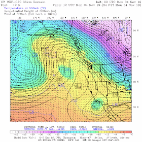
We are now in the middle of Northwest fog season and the conditions are nearly ideal for low-level fog and low clouds. The nights are getting much longer, allowing good radiational cooling from the surface. We had rain, so the surface is relatively moist. A high pressure ridge is just offshore producing sinking air over the region (see figure). High pressure is good because it suppresses upper level clouds and produces warming aloft (sinking air is compressed and warms). High pressure also produces weak winds--which is helpful for fog, since strong winds mix the cold air away from the surface, lessening the potential for cooling to saturation (and thus produce fog).
Meteorologists would like to see the extent of the fog at night---but there is a problem. Visible satellite imagery doesn't work at night, because, well, it is night. Infrared satellite imagery works all the time by sensing the temperature of the clouds--but there is a problem regarding fog. Fog is very shallow (typically from meters to a few hundred meters deep) and thus the temperature of the top of the fog is very similar to that of the ground. This is particularly true of fog-prone nights when there is frequently an inversion (temperature warming with height near the ground) or little change in the vertical near the surface.
So how do we track fog at night from space? It turns out that weather satellites look at the earth in many wavelengths (or channels), and the difference between one of them (3.9 microns, a micron being a millionth of a meter) and one of the infrared wavelengths (10.3 microns), can indicate where low clouds are at night. This difference is called the Fog Product.
We had fog products with the old NOAA/NWS geostationary satellite (GOES 15), but a year ago, the new National Weather Service GOES satellite was launched (GOES 17) and its higher resolution is just a home-run regarding the clarity of the fog images.
Let me show you. Late Sunday night, there was little fog/low clouds over the interior, but plenty offshore, with some of the densest fog along the coast.
By 1 AM, fog was forming along the I-5 corridor south of Olympia (an infamous fog hole) and along the Columbia River. Some of NW Washington.
But around 6 AM today, fog had really expanded over SW Washington and the northern Willamette Valley, Portland had lots of fog. There was some high clouds over the NE part of the domain that was interfering with the fog product....hard to get around that.
Knowing the extent of fog is important for transportation (airports, highways), among other reasons, so knowing the distribution of fog is extremely useful.
One of the first visible images this morning, showed the fog was a reality!
Finally, fog is generally not the best forecast field by our numerical models, but high-resolution models are getting better at it. To illustrate, here is a 15-hour forecast from the UW, uber-high resolution WRF system for low clouds and fog valid at 7 AM. Not too shabby.
Finally, remember that on cold nights be careful driving when there is fog on or near the road. Fog can quickly lay down ice on any road that falls below freezing.


Hugely useful for mariners and aviators... Has the potential to save lives... where's the best place to find such maps...? Doesn't seem to have made it to all weather products yet...
ReplyDeleteNot sure where the source data is from, but you can filter to show 'fog' on windy.com
DeleteCan the public access the GOES-17 fog product?
ReplyDeleteThe lack of fog just offshore of Gray's Harbor is interesting. Could that be due to localized warming of surface water from industrial activities in the Aberdeen/Hoquiam area?
ReplyDeleteThat looks more like the effect of the outflow of the Chehalis River.
ReplyDeleteIt's very interesting to follow your meteorology methods, Cliff! I always enjoy the satellite images. Fog seems mysterious and it's good to know the facts about it.
ReplyDeleteCheck out this view across the fog in Portland from radio towers in the west hills:
ReplyDeletehttps://www.facebook.com/fox12weather/photos/a.124227760960626/2665528486830528/?type=3&theater
Here is a U of W fog URL: https://a.atmos.washington.edu/~ovens/wxloop.cgi?vis1km_fog+1
ReplyDeleteI only want snow........
ReplyDelete