Tuesday is going to be a day of great contrasts in the Northwest, and particularly west of the Cascade crest.
It will start off cold--in the lower 30s-- with overcast skies.
As the clouds thicken, light snow could fall during late morning or early afternoon over some of the western lowlands. Nothing to worry about.
The temperatures will rapidly warm and the snow will turn to rain during the afternoon
And then the rain will get steadily harder, while the winds increase and turn blustery.
Cold, snow, rain, wind, followed by warmth. All the basic food groups of Northwest winter weather. What a wonderful place to live!
Tonight, a plume of clouds and moisture is approaching our region (see below).
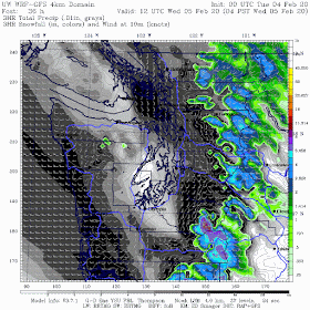
In this blog I will show you a new graphic from the UW high-resolution modeling system. One that shows precipitation, but separates wet stuff into rain (gray scale) and snow (colors). Very educational.
At 10AM tomorrow, rain is just reaching Puget Sound, where marginally cold enough air (for snow) will be in place (this graphic is actually showing the 3-h precipitation ending at 10 AM). Snow starting in higher elevations.
But there will be evaporation and melting of snow falling in from aloft. As a result, the next three hours (through 1 PM) is forecast to bring light snow to Seattle. Wet snow.
But is won't last. Three hours later, there is rain in Seattle, with some snowflakes over Snohomish County and the western slopes of the Cascades.
For the 3-hour period ending 7 PM tomorrow, rain, in some places heavy, has extended over all the lowlands, with snow retreating to higher elevations as the air warms.
And by 4 AM Wednesday, heavy rain is now widespread and snow is only falling in the high Cascades.
What about winds? The forecast winds of Seattle predicted by Seattle WindWatch are shown below.
This is a sophisticated ensemble (many forecast) product, which suggests an acceleration of the winds to roughly 30 mph tomorrow night, with the highest resolution forecast going for over 40 mph. Not a huge windstorm, but with heavy rain, you will notice the breeze.
And did I mention the expected river flooding from all the warm rain expected during the next two days? Loads of local rivers will be at bankful or flooding (see the forecast from the NWS River Forecast Center below)
So find a good book or video, and be ready to settle down in a cozy spot tomorrow evening while the rain is providing some pleasant white noise outside.


Lets talk about feb 12-14?
ReplyDeleteLooks like a cold snap. Maybe similar to last year mid February
DeleteThe new UW HR model looks good, but it feels like a reversal in color from what the public is used to. That should change.
ReplyDeleteI second this comment... proper selection of colorbars (especially in scientific communication) is essential in order to convey clear information without biases. The argument usually centers around the Jet/Rainbow colormap but should also be relevant to the choice of colors used in context with the parameter they are connected to.
DeleteGreen/yellow/Red (although not the color of rain) may be interpreted as radar reflectivity here and whites/greys are usually associated with snow (and have a visual connection to the white stuff).
Wind contour coloring output (not shown in this post this time) could also use some help... as I usually can't follow along with the rainbow pastels used.
Ok... Yay!
ReplyDelete