You are not alone. Many on the western side of Washington State noted the phenomenon, which I will term a Dry Storm. And it is about to get revved up again!
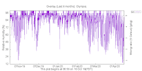
To get some perspective, here is a plot of the relative humidity at Seattle Tacoma Airport over the past six months. Two days ago, the relative humidity dropped under 15%, the lowest since October 29th.
At Olympia, Monday brought the lowest relative humidity for the entire six months.
So what about the amount of water vapor in the air, say at Olympia. A good measure of water vapor content is the dew point temperature: the temperature to which air has be cooled to saturate it (100% RH). If air is full of water vapor, you don't have to cool it as much--thus, higher dew point. The plot below shows a plot of dew point at Olympia over the past six months. It was quite low, but not as low as October 29th. The very low RH on Monday was the combination of low water vapor content and a relatively warm day.
So why was the relative humidity so low on Monday and why is it going to happen AGAIN on Thursday? Good question.
It has to do with the weather pattern we have been in, with a large upper level ridge and inland high pressure pushing dry air from the Northwest interior westward into western Washington.
Let me show you a series of relative humidity forecast maps for our region...and I warn you, you might put on some lip balm before you view it.
This morning we have had a bit of a moist reprieve. The forecast surface relative humidity map for 5 AM shows higher values (blue colors) as moist air flooded western Washington. There are lots of low clouds this AM. No wonder I slept better last night.
But tonight, cooler air and high pressure will move into Montana and Idaho, creating offshore (easterly) flow over our region. The forecast map for 5 AM Thursday (below) shows this, with blue colors indicating cooler temperatures. Look closely (or click on image to expand) and you will view the surface winds being offshore-directed over Washington State. Note the air warming as it descended the western slopes of the Cascades--that is due to compression warming as air goes from low pressure aloft to higher pressure at the surface.
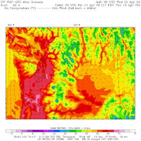
The relative humidity forecast forecast for 5 PM Thursday (below) is, well, withering west of the Rockies, with some values in western Oregon and Washington getting below 15%. We can call it Dry Storm2.
The surface air west of the Cascade crest will not only be dry but warm, with highs in the upper 60s over Puget Sound and 70s in the Willamette Valley (see temperature forecast below for 5 PM Thursday). Reds and pinks are the warmest. And yes...no rain. This persistent pattern has resulted in essentially no precipitation over us for the past two weeks and none is expect during the next 7 days.


Low humidity and dewpoints=low minimum temps.Cover up your temperature sensitive plants!
ReplyDeleteYeah, I've noticed. It's a lot more difficult to farm and protect baby plants with the dry wind. I'm looking forward to rain to save the seedlings, but also to knock the high pollen counts down.
ReplyDeleteHopefully it goes back to normal as low humidity can cause folks to be more susceptible to virus infection due to dry sinus and other surfaces being more easy to penetrate.
ReplyDeleteDoes this portend an early start to the fire season? Hopefully not.
ReplyDeleteCheck the snowpack and ytd precipitation, we're fine.
DeleteBut we also have to look at soil moisture.
DeleteThanks for posting about this, Cliff!
ReplyDeleteI've noticed that my location in NW Bellingham rarely, if ever, gets as dry as areas to the south when the direction of the wind in the lower-levels of the atmosphere is from the east. Whatcom County has no direct atmospheric conduit to the east side of the Cascades as the Nooksack River's source and thus, the valley through which it flows, is far to the west of the Cascade Crest. Easterlies/downslope winds are quite uncommon here.
I've wondered why Fraser Outflow does not usually seem to generate the extremely dry, red-flag conditions here that occur when the wind comes roaring down the valleys south of Stevens Pass toward Puget Sound. Any ideas why the dryness never seems quite as extreme north of the Chuckanuts?
The maximum temperature at my location in NW Bellingham today was 65.1F - the warmest temperature of the year thus far and the warmest it's been in nearly 7 months.
ReplyDeleteAs utter wishful thinking we might suppose that a viable Cov-Sars-2 virus particle in a droplet will dry up, denature, and become in-viable at a higher rate during a "dry storm".
ReplyDeleteProblem is that this kond of virus is "enveloped" in a lipid layer that has been shown (in related coronaviruses) to harden and thus better protect the viability of the virus when the temperature and humidity are lower. But so far we don't know if this coronavirus will behave similarly.
Deletenoticed that the temperature was climbing to 69F at kirkland at around 1 PM but then started to drop to 66, now at 2 PM. could it be our version of sea breeze?
ReplyDeleteHi Clliff. Thank you so much for your blog. It is such a resource! I was wondering if you would consider touching on the tree pollen or if that fits in the scope of wx. It seems unusually fierce and long lasting this year. We are in the San Juans.
ReplyDeleteThe pollen is incredible...foliage looks green and dry, cars sitting around are becoming camouflaged, as will we if we sit still outside for too long. Long Live Conifers!
ReplyDeleteAt 66.1F, today was, again, the warmest day of the year thus far at my location in NW Bellingham and looks to be the warmest day until next month. It appears I may be on track for an 8-month streak between 70F days. It's certainly been sunny, though, with ~22MJ/m^2(6kWh/^2) of irradiance today.
ReplyDeleteThe Washington Post is reporting this morning on a study published on 4/16 in the journal Science. The study (according to the Post) concludes that the Western U.S. is locked in the first human-caused mega-drought. I'm curious about your comments on the study.
ReplyDeleteClear nights make for cold overnight lows in the mountainous areas. And while it's been a great time to tidy wintered weeds, but the soil's still much too cold for grass seed to germinate. I wouldn't set out an "annual" till mid-May. These cold overnight lows keep some shaded high-elevation stream banks frozen, too. Without rain and ephemeral and intermittent surface runoff, the dynamics of perennial baseflow are obvious. Low streamflow during periods like this are still well within normal range, at least here.
ReplyDelete