A look at the infrared satellite image at the same time shows no weather disturbances out there (see below). Just some clouds to the north (associated with system that will bring us rain on Saturday).
A high resolution visible satellite image taken just before sunset on Thursday confirms the lack of weather offshore. But note the low stratus and fog right along the coast....that will be important later!
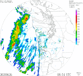
So is the expensive Langley Hill radar broken? Is rain falling out of clear skies? Is there an explanation for this mystery?
There is an answer: super bending of the Langley Hill radar beam by an unusually strong and low inversion, where temperature increases with height.
Let us take a look at the vertical sounding of temperature, dew point, and winds with height from the balloon-borne radiosonde released at Forks, on the Washington coast, around 5 AM this morning.
Note how temperature (the right-hand line) increases with height in the lower atmosphere. That represents an inversion. The left line is dew point temperature; when dew point and temperature are the same, the air is saturated, which was true near the surface.
Yesterday afternoon, cool, but shallow, marine air moved into the coast, while warm air remained aloft. The result was a fairly strong inversion in the lower atmosphere. The visible satellite image showing the low clouds on the coast were a hint of what was going on.
So why do we care about inversions? Because they can bend the radar beams (which are in the microwave portion of the electromagnetic spectrum--around 10 cm in wavelength).
A strong inversion can bend the radar beam down to the earth's surface in what is known as superrefraction (see image). The earth's surface (in this case the ocean) is a pretty decent reflector of the radar signal and a good amount propagates back to the radar, giving a false signal of heavy precipitation. That is why the radar showed the arc of supposedly heavy rain offshore. Totally bogus.
Now in the typical atmosphere, with denser air at low levels and less dense air above, there is normally some bending of the radar beam, which is a good thing because it gives the radar greater range (see below)
There was simply too much of a good thing last night! And don't worry, real rain will get to Washington this weekend, with our weekend weather curse continuing.


The computer algorithms that interpret radar data can't deal with all situations. I've seen questionable radar signatures of tornado activity in local storms, possibly because of some marginal storm rotation when the system doesn't have the energy. Some TV channels under some circumstances drop out because of refraction layers that form locally, despite having a high gain antenna aimed at local channels that aren't quite line-of-sight.
ReplyDeleteI've experienced rain from blue sky. 5 minutes later a half-cloud formed above me.
ReplyDeleteNoticed at the bottom of the chart "University of Wyoming." Really?
ReplyDeleteThat's just the website source for the skew-T diagram Dr. Mass used. You'll notice the sounding location is listed in the top left.
DeleteCliff, I have noticed that there is often a blob of rainfall on weather radar in the northeast Olympia Mountains just east of Quilcene. This is often seen even when there is little or no precipitation elsewhere in northwestern Washington. Is this another radar anomoly or a real phenomenon? If real, what is the mechanism for causing rain so frequently in that area. Apologies if you have previously addressed this and I missed it.
ReplyDeleteCorrection: just west of Quilcene.
DeleteToday, we have the opposite. About an hour ago, it was quite clearly raining at my house in north Seattle, but the radar imagery showed no precipitation, leading my weather app to tell me that rain was possible at 6:30 (5 hours later!) when it was falling on my head. I'd love to see Prof. Mass write a companion article about this phenomenon!
ReplyDeleteCliff,
ReplyDeleteReading "curse" made me laugh. It does seem that way.
On Behalf Of Environmentalists, I Apologize For The Climate Scare
ReplyDeletehttps://environmentalprogress.org/big-news/2020/6/29/on-behalf-of-environmentalists-i-apologize-for-the-climate-scare
Is Saildrone weather forecasting accurate?
ReplyDelete