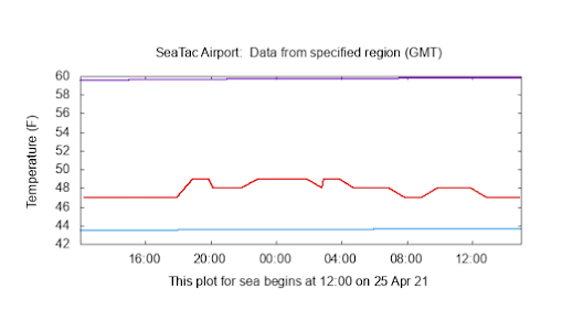
The temperature yesterday in Seattle was extraordinarily flat-lined, varying by only a degree or two over 24 hours.
If the weather was a patient, we would be getting out the defibrillator paddles to shock the meteorological heart back into action.
To show you this remarkable absence of temperature variation, here is a plot of surface air temperature at Seattle Tacoma Airport over the past two weeks. Most days had a healthy diurnal (daily) range of temperatures, with some (April 17-21) with as much as 40F between the daily minimum and maximum. April is generally a month with big temperature swings since the sun is quite strong (similar to August).
But look at the last day (through 8 AM this morning).....very little change at all.
The temperature plot for the 27 hours ending at 8 AM this morning is stunning, ranging from 47 to 49F.
Looking at the past several years, I could find no April day so boringly dull.
Why so dull? Blame continuous cloud cover and steady light rain. Hour after hour of benighted drizzle.
The visible satellite image at noon PDT yesterday shows the story, with a dense cloud cover over the region.
As a result, the amount of solar radiation coming in was VERY low, as illustrated by the solar radiation plot at Seattle for the past two weeks from WSU's AgweatherNet.
Like one-third of the peak of the others days of the period. You did not have to worry about getting a sunburn yesterday.
But there was a silver lining to the drizzly cool day: pollen levels plummeted to low levels, providing relief to allergy suffers.
Sensitive folks had been complaining to me recently, since the warm period we just went through really ramped up pollen levels in the air (see pollen level plot for the past month from pollen.com).
Since April 11th, pollen levels were high (red), but decline yesterday to low to medium.
But allergy suffers should not put away their meds, the improvement is only temporary. The latest model runs suggest a modest upper-level ridge will rebuild over the east eastern Pacific by Wednesday (see below), which will warm us up and ensure no precipitation for days.
And the National Weather Service GEFS ensemble forecast for surface air temperature at Seattle, which makes use of multiple forecasts, each a bit different, indicates steadily increasing temperatures this week, reaching around 70 F on Thursday, followed by a rapid cool off (and wettening) for next weekend (sorry).
At least no frost to threaten any tomato plants you might have put outside!
______________Announcement
The Northwest Weather Workshop, the annual gathering to talk about Northwest weather, climate, and major meteorological events, will take place on May 1, 2021. This year we will have a special session on the meteorology of the September 2020 regional wildfires. The meeting will be online. More information, the agenda, and registration information is found here: https://atmos.uw.edu/pnww/


Cliff: Any comments on the nomination of a new NOAA administrator, Rick Spinrad?
ReplyDelete