There is a good chance that La Nina--cooler than normal waters in the central tropical Pacific-- will return this fall. And the reprise of La Nina has major implications for the weather of the upcoming winter.
As I have discussed many times in this blog, there is only one truly useful tool for predicting Northwest weather months in advance: the correlation between temperatures of the central tropical Pacific and the weather circulation over the western U.S.
A rough cycle, called ENSO (El Nino Southern Oscillation), shuttles between warmer than normal water temperatures (El Nino), to near normal conditions (neutral), to colder than normal tropical waters (La Nina). The period of this cycle is approximately three to seven years. The figures below illustrate the changes between El Nino and La Nina.
You can think of the cycle as analogous to water sloshing back and forth in a bathtub, with less dense, warm water on top. When the warm water sloshes to the east, you have El Nino. To the west, La Nina. In the images below, you are viewing the Pacific basin and red colors indicate warm water.

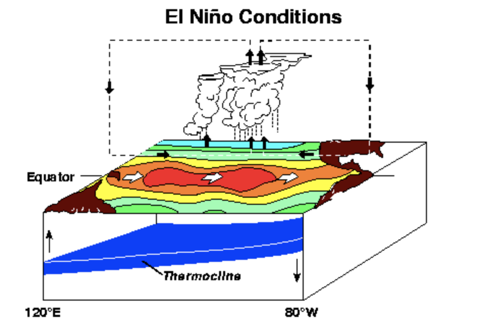
You will note that convection and thunderstorms follow the warm water--this is important.
The trade winds are strongly out of the east during La Nina years (white arrows) but reverse during El Nino years. All of these changes influence the atmospheric circulation away from the equator...including over the Northwest.
So let me get to the punch line. During La Nina years, the Northwest tends to be cooler and wetter than normal. Typically more snowpack in the mountains. And increased chances of lowland snow.
La Nina works against drought in the Northwest. But the situation is just the opposite in central and southern California, where La Nina years are typically dry. Bad for wildfires and water supply in the Golden State.
The Prediction for this Winter
I generally refrain from blogging about La Nina/El Nino status until mid-August because such forecasts are far less reliable until the summer. But we are far along now into the summer, so I can provide some useful guidance.
To follow El Nino/La Nina we generally monitor the temperatures in the Nino 3.4 area in the tropical Pacific (see map below)

The deviation of the temperatures in that box from normal is shown below. Much cooler than normal last winter, when we were in a La Nina. That is why we ended up to with a very healthy snowpack, by the way.
But La Nina weakened during the spring and we are now in neutral conditions (temperatures roughly within .5C of normal).

Importantly, La Nina appears to be rebounding again. Cold water is strengthening beneath the surface, as shown by the blue colors in the figure below, which provides an east-west vertical cross-section in the tropical Pacific.

And based on both simulation and statistical models, the Climate Prediction Center is predicting the resurgence of La Nina (blue colors) this fall.


It would be great if just this once the MSM would accurately report on this development. Only yesterday the media here were screeching about our lack of rain this summer...but we're only down by one inch so far in Portland. Granted, we're definitely down for the year, given the lack of expected spring rains, but still.
ReplyDeleteThe media is right for the most part, but it might depend where you are. On the Olympic Peninsula, this was the 7th driest July in the last 127 years. Mountains got lots of moisture last winter, but lowlands not so much. We are in a moderate drought. And some areas in eastern WA are in extreme to exceptional drought.
DeleteThe MSM should be talking about drought. It's not nearly as bad here as CA, but its real here.
we are down about six inches on our rainfall here in EW and a wet La Nina would be good
ReplyDeleteWe love your podcasts ... So much to learn ! We are a bit older and find it hard to hear at times. It seems to us that your voice frequently trails off and becomes softer. Do you have any way to fix this ? We already have the volume set at the maximum. Many Thanks for sharing your knowledge and excitement about the weather with us.
ReplyDeleteThat's the forecast I was hoping for. With the exception of the very hot days in June, it has been a beautiful summer here in Northwest Oregon. If we have average or above average rainfall in Fall and Winter, that would be really nice.
ReplyDelete