January 30, 2022

What Goes Up, Must Come Down. What Do You Do When You Find a Radiosonde?

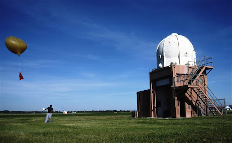
 One of the backbones of the meteorological observing network is the radiosonde, a balloon-launched weather station that rises to around 110,000 feet before the balloon bursts and the instrument package plummets back to Earth, slowed by a small parachute.

Such radiosondes are launched twice a day at approximately 1000 locations around the world.

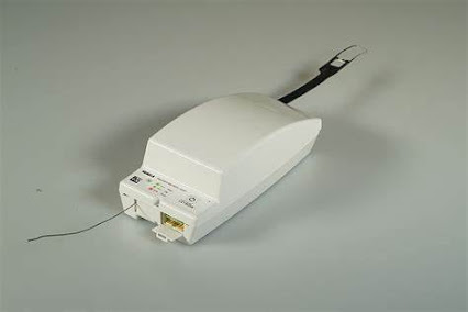
Most U.S. National Weather Service sites use a radiosonde made by the Finnish company Vaisalla, and specifically, the RS 41 unit shown below.  The projection at the top has the temperature and humidity sensors, a digital barometer is inside, and winds are derived by tracking the movement of the unit.


One of the great pleasures of doing this blog is the emails I receive from many of you, with all kinds of observations and questions.  

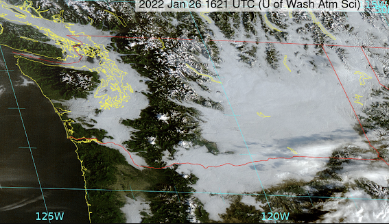
Well, today I got an email from Ian Cruickshank; while he was hiking in the forest in the Sooke Hills near Victoria, BC, guess what he found?  An American radiosonde unit (see the proof below).


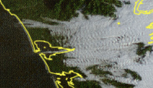
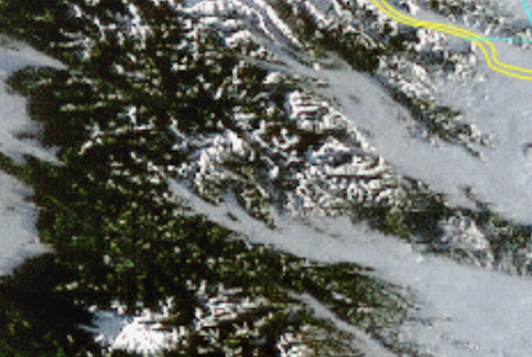
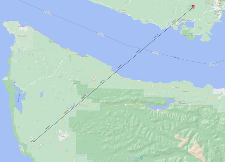
He asked me where it was launched and I knew there was really only one possibility: the National Weather Service launch site at the Quillayute Airport on the Olympic Peninsula.   Here is a map showing the radiosonde launch location and where the unit ended up. About 55 miles away.


I am often asked what one should do with one of these units if you find one.  In the old days, the NWS wanted you to return them....no longer.  Just trash it...or better yet, keep it as a rare souvenir.

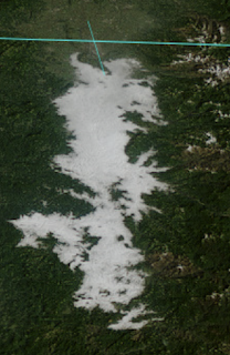
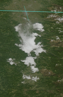
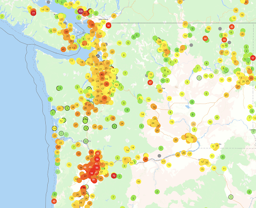
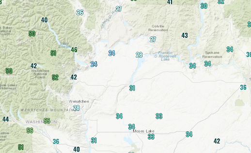
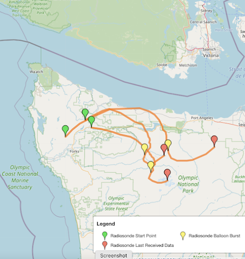
There are hobbyists that maintain websites that track radiosondes, acquire their weather data, and attempt to find them after landing.   One such site showed the recent landing locations of the radiosondes launched from Quillayute the past few days (below).  Most of them landed in Olympic National Park.


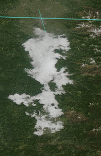
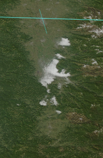
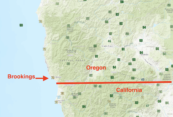
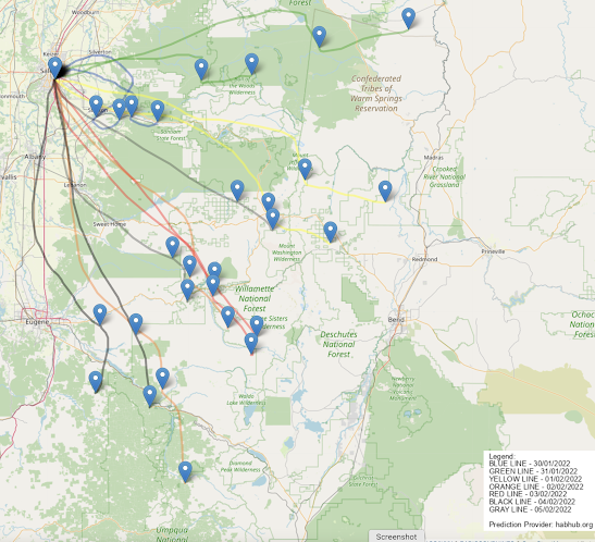
And consider the routes taken by the Salem, Oregon radiosonde (see below)--mainly landing in the central Oregon Cascades.  That looks like a good place to go radiosonde searching.


If there is a really strong jet stream, radiosondes can travel up to two hundred miles downwind during their typical two-hour flight.

Perhaps the most amusing radiosonde recovery story occurred a few years ago in my Atmospheric Sciences 101 class.  I had just given a lecture about radiosondes and the next day a student walked in with one.  Smiling.   I was dumbfounded.  While he was playing basketball at a frat house in the University District, a radiosonde had floated in.   

I gave him extra credit, of course.


January 28, 2022

The Truth about Ancient Weather Proverbs. Plus, the Latest Forecast

The weather wisdom of the ancients.

Red sky at night sailors delight, red sky in the morning sailor take warning.


Or perhaps from the Book of Job.

Fair weather cometh out of the north


Weather proverbs and sayings are found in virtually every human culture.  Based on modern meteorological knowledge, do they make sense?

The answer is found in my new podcast.  And so is the latest forecast, which includes rain on Sunday and a cool, but generally dry, next week.

To listen to my podcast,  use the link below or access it through your favorite podcast service.


Some major podcast servers:

 HTML tutorial HTML tutorial
Like the podcast? Support on Patreon 


January 26, 2022

Marvels of Fog and Low Clouds

Like many days this week, this morning dawned with low clouds and fog trapped under an inversion (see image for this morning).  Eastern Washington and interior western lowlands were pretty much covered in a thick blanket of white.


But although low clouds might seem unremarkable, there are subtleties to the observant eye that reveal much about our local meteorology.  And there is beauty there as well.

Take sunrise.  The visible satellite image taken just as the sun was coming up reveals the long shadow of Mount Rainier extending over the low clouds, like a dagger pointing to the northwest (see below).


The tip of the point is just south of Tacoma.

An hour later, the image around Hoquiam is revealing.   A narrow jet of fog is pushing westward into Grays Harbor.  And there are waves on the low clouds.  The fog exists in cold, dense air and this layer acts like a water body with waves undulating on its top.


And then there are the tendrils of fog moving up river valleys.  For example, higher pressure in eastern Washington is pushing fog/low clouds westward into Snoqualmie Pass and Steven Pass.  A good reason to take the lifts to the highest slopes available.


And satellite imagery reveals how fog burns off...something we didn't know about until we could view it from space.  Fog burns inward from its edges.  

You want to see?  Check out the imagery below for the Willamette Valley at 10 AM, noon, 1, 2, and 3 PM.


And perhaps the greatest treat is to hike above the low clouds into bright sunshine and to view the spectacular from aloft.   My plan for Saturday morning!


January 24, 2022

Air Quality Declines As Inversion Slowly Weakens Overhead

 Inversions, in which temperatures INCREASE with elevation,  suppress vertical mixing, which in turn allows pollutant concentrations to increase near the surface.

And with a strong inversion over western Washington and Oregon the last few days, air quality has degraded to moderate levels at several locations.  

To illustrate, below is a map  (at 7 PM today) showing the concentrations of small particles (less than 2.5 millionths of a meter) that are capable of passing deep into your lungs. Nasty stuff.

 Low concentrations are green, with moderate values in yellow and orange, and red being even higher.  The Puget Sound region has degraded air quality and it is even worse around Portland.  Generally good in the mountains.


Graphic provided by PurpleAir

You can see the declining trend of air quality in Seattle with a plot of the small particle concentration during the past few days (below).  A progressive upward trend in small particles.


The sources of the particles include combustion from heating, burning of gas and diesel fuels in cars, and from burning wood in fireplaces and wood stoves.

During most winter days, these emissions are little problem around here, with stormy, wind conditions and an atmosphere that facilitates vigorous vertical mixing of air in the lower atmosphere.

But during the last three days, high pressure aloft has produced a well-defined inversion, as noted in the vertical sounding at Quillayute this morning at 4 AM. (Quillayute is on the northern WA coast)--see below.  Red is temperature, the x-axis indicates temperature (°C) and the y axis is height in pressure (700 is about 10,000 ft) 

You can think of an inversion as a meteorological barrier to air motion.  Here is a beautiful example of what happens when smoke hits a low-level inversion (see below).... it is like hitting an invisible barrier.

Image by S/V Moonrise

The particle concentrations we experienced the last few days are NOTHING compared to what we breathed during wildfire events, something shown by the plot of small particle concentrations from summer 2017 to now (see below).   September 2020 was the big "winner" with values about ten times higher than what we experienced today.


The good news is that our winter concentrations are getting lower and lower, as fewer homes burn wood (very dirty), cars and trucks get cleaner, electric cars become more numerous, and with effective burn bans and other restrictions by air quality groups like the Puget Sound Clean Air Agency.

And some other good news...the inversion is weakening and will probably break later today--maybe even with a glimpse of the sun.  And stormier conditions will return on Friday.

Prepare to take a deep, healthful breath!


January 23, 2022

The Southern Oregon Coast Hits 79F as a Super-Inversion Develops over the Northwest

Update at the end!

High pressure and a super-inversion have developed over the Northwest, and jaw-dropping weather contrasts have developed--both in the horizontal and the vertical.

For example, yesterday (Saturday) temperatures zoomed up to near 80F on the southern Oregon coast, with 79F at Brookings, Oregon (see yesterday's max temps, below, click on the image to expand).  The forecasts were right.


At the same time, temperatures were in the 40s in eastern Oregon and BELOW FREEZING in large sections of the Columbia Basin of Washington (see Saturday's high temps below). 

If you were in frigid, sub-freezing Wenatchee yesterday and wanted to warm up by 20F you could do it--by going up into the mountains.  


This morning, the Puget Sound lowlands are enshrouded in fog, but clear skies are only about 1000 feet above.  

Want proof?  Here is a picture from around 1200 ft in Bellevue, looking west, provided by Dr. Peter Benda.  Fog covers the lowlands, but blue skies are aloft.


Or this picture from the top of West Tiger 3 (2500 ft) by 
Dr. Steve Cobert.  Cougar Mountain is an island in a sea of fog and low clouds.


The pattern is confirmed by the visible satellite image at 8:16 AM this morning (below), with the western lowlands enshrouded by fog, as is the Columbia Basin.  But the coast is clear.


The origin of these sharp contrasts is strong high pressure, which has produced a super-inversion over the region.

The upper level (500 hPa, about 18,000 ft) for yesterday at 4 PM (shown below) clearly indicates a strong ridge of high pressure just offshore.   And just east of such ridges, very strong sinking occurs.


Such sinking produces what is known as a subsidence inversion.   An inversion is when temperatures INCREASE with height over some layer of the atmosphere, which is the inversion (opposite) of what normally occurs:  temperature decreasing with height.  

Why do high-pressure areas create inversions you ask?  

 Because sinking air is compressed and warmed.  The sinking is larger aloft but weakens towards the surface (because the ground is in the way!).    Also the clear skies aloft air enable radiational cooling from the surface before any fog forms.

Let me show you how impressive the inversion was this morning.  The radiosonde-based vertical sounding at Quilayute shows warming of about 18C (roughly 32F) in the lower few thousand feet (see below).  WOW.

And aircraft coming into and out of SeaTac airport measure temperatures, and this morning at 8 AM temperatures increases from the lower 30s near the surface to the 50s above 2000 ft.  Double wow.

Image from Seattle SnowWatch, funded by the City of Seattle

Hike to the top of Tiger Mountain today (at about 2500 ft) and you can have your lunch in bright sun and perhaps 60F, with your hike starting near freezing.  My kind of hike.

High pressure will be hanging around through Thursday, after which precipitation will return to the Northwest.  It has been a nice break from the rain, providing a chance for things to dry out a bit and lessening the chances for landslides and slope failures after a very wet period.
______________________________________

Important Update at 3:43 PM

With a strong inversion, there was a huge difference between the temperatures at Tiger Mountain Family Nudist Park --37F-- (elevation 646 ft) and Poo-Poo Point (about 1550 ft) -55F (see map below).   In fact, Poo Poo Point, which is known for hang gliding,  peaked at 57F.

So roughly 20F higher about 900 ft up.  A very strong inversion.

I suspect the Nudist colony folks may be moving up the hill to Poo Poo Point today for obvious reasons.  Stay tuned, this could get interesting!  


January 21, 2022

High Pressure's Two-Edged Sword: Heat and Cold Fog. Plus the Weekend Forecast in My New Podcast

 High pressure has built over the region and will strengthen on Saturday (see surface map for 4 AM Saturday morning).


Strangely enough, high pressure during the winter can have two localized impacts on our region:  cool, foggy conditions in the western lowlands, OR very warm, sunny conditions where downslope flow is forced by regional terrain.

Such will be the situation this weekend, where northern Puget Sound will be dank, cloudy and cool, while the Oregon coast (and to some degree the southern WA coast) will enjoy sun and warmth.  The Columbia Basin will also be caught in the murk and cold.

To illustrate the wildly varying situation, here is the forecast surface air temperature for 1 PM Sunday.  Some places on the Oregon coast will get into the lower 70s, while Puget Sound will be in the lower to mid-40s.  BELOW FREEZING in the Columbia Basin.  Quite nice on the Long Beach Peninsula.  COLD over Northwest Washington.

Want to know why such extremes occur over our region during high-pressure situations?  

Or get more details about the forecast?  Check out my podcast--either with the link below or through your favorite service.


You can listen to the podcast below or through your favorite podcast server.


Some major podcast servers:

 HTML tutorial HTML tutorial
Like the podcast? Support on Patreon 


January 19, 2022

"Code Red" on the Oregon Coast

 Don't worry,  this time code red is a good thing.

Below is the latest high-resolution surface temperature forecast for Saturday at 4 PM.  Red colors are temperatures above 60F along the Oregon coast!    The kind of code red I like.  And near Brookings, just north of the Oregon/CA border temperatures surge into the mid-to-upper 60s.


On Sunday, the code red temperatures are even more extensive along the coast as well as extending along the western slopes of the Oregon Cascades,


The highly skillful European Center model is going for 66F in Brookings, Oregon on Saturday....and 62F on Tuesday.  Brookings is well known for being the warmest location in the southern Oregon "banana belt."  And there is a reason (more later).


Our "code red" temperatures are associated with a high-amplitude upper-level (500 hPa) ridge over the northeast Pacific, with two "bookend" troughs on both sides (see below).  This is a very stable pattern.


Why does high pressure aloft make us warm--and particularly over the coastal zone? 

 First, high-pressure areas are associated with sinking air that prevents mid-level and upper-level clouds.  More sun! And the sinking air is also warmed by compression.   

But to really understand the implication of the upper high pressure, let's examine its reflection at the surface, illustrated by the forecast sea level pressure pattern at 4 PM Saturday (shown below).  The surface high is centered just offshore of central Vancouver Island, with northeasterly flow (winds from the northeast) to its southwest over coastal Oregon.


Northeasterly winds can sink over the western slopes of the Cascades and coastal terrain, producing MORE compression and warming.  Brookings is in the "banana belt" for a reason...it is downstream an area of continuous high terrain, extending all the way from the coast to the Cascade crest (see below).   So when the air sinks down such terrain it is very warm.

Northeasterly winds also keep the cool marine influence offshore and prevent the development of low-level fog and low clouds. 


So if you can, head to the Oregon coast this weekend for sun and springtime warmth.  Will be a bit cooler (mid-50s), but still decent in Long Beach, along the southern WA coast.   

But the southern Oregon banana belt is where you want to be.  Mid-60s and sun in mid-January is a real treat around here.


January 17, 2022

Mega Ridge of High Pressure will Lead to Perfect Coastal Weather

After months of jet streams, atmospheric rivers, snowstorms, cold waves, and low centers, a huge persistent ridge of high pressure will soon form along the West Coast.

But you will have to be patient.  For three more days, a series of weak systems will bring precipitation to the area. But then the region will turn dry, and in one area, the Pacific Coast, the temperatures will rise to very pleasant levels.  Book your room now!

First, the ridge. On Friday, high pressure will explode over the eastern Pacific and by 1 AM Saturday, the mother of all ridges will be evident aloft (500 hPa pressure level, about 18,000 ft) shown below.   Two troughs of lower pressure/heights are found on the sides.   This produces an OMEGA pattern, which is very stable.

UW Model Forecast for 1 AM Saturday


This pattern will hold in for the weekend and beyond.  At the surface, high pressure will be centered just offshore of Vancouver Island and inland, producing moderate easterly flow over the coastal zone of Oregon and southwest Washington.  Temperatures will warm as air sinks as it moves around the high and down the western slopes of coastal terrain (see sea level pressure map, with low-level temperatures, at 1 PM Saturday).


When I saw this chart I smiled and thought about immediately booking a room somewhere in the "banana belt" of the southern Oregon coast.  Let me show you why!

Here is the forecast of surface air temperature for 1 PM Sunday. Lots of reds--temperatures ABOVE 60F--along the coast west of the coastal terrain.   Warming offshore flow.  And the warmth will extend along the entire Oregon Coast and even southwest Washington (e.g., Long Beach).  Folks, it will feel like summer---a guarantee it!


In contrast, below freezing air will be ensconsed in eastern Washington, probably with some fog to boot.

The southern Oregon coast....a.k.a. the Banana Belt...is famous for enjoying warm days in winter.  All it takes is easterly (offshore) flow descending the regional terrain.