Update at the end!
High pressure and a super-inversion have developed over the Northwest, and jaw-dropping weather contrasts have developed--both in the horizontal and the vertical.
For example, yesterday (Saturday) temperatures zoomed up to near 80F on the southern Oregon coast, with 79F at Brookings, Oregon (see yesterday's max temps, below, click on the image to expand). The forecasts were right.
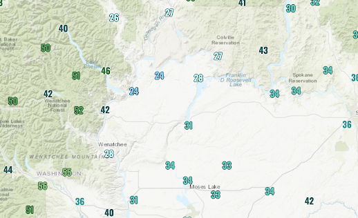
At the same time, temperatures were in the 40s in eastern Oregon and BELOW FREEZING in large sections of the Columbia Basin of Washington (see Saturday's high temps below).
If you were in frigid, sub-freezing Wenatchee yesterday and wanted to warm up by 20F you could do it--by going up into the mountains.
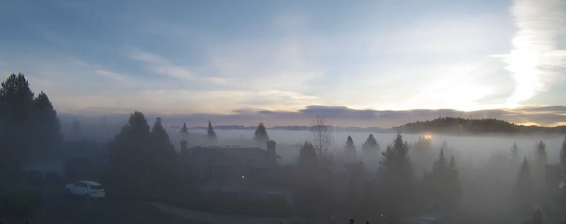
This morning, the Puget Sound lowlands are enshrouded in fog, but clear skies are only about 1000 feet above.
Want proof? Here is a picture from around 1200 ft in Bellevue, looking west, provided by Dr. Peter Benda. Fog covers the lowlands, but blue skies are aloft.
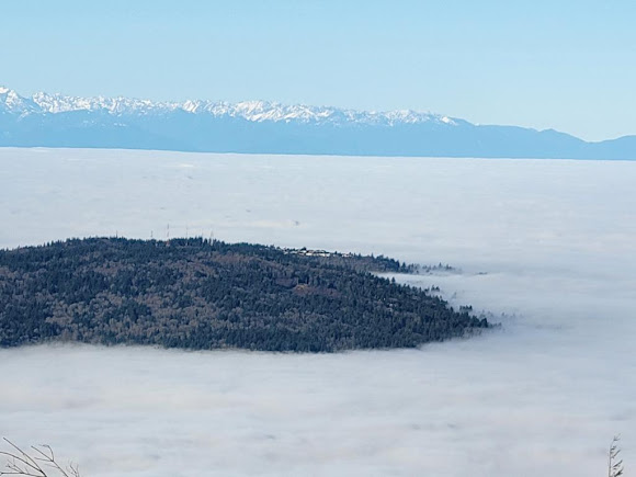
Or this picture from the top of West Tiger 3 (2500 ft) by Dr. Steve Cobert. Cougar Mountain is an island in a sea of fog and low clouds.
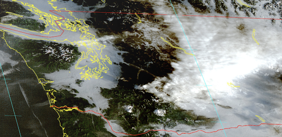
The pattern is confirmed by the visible satellite image at 8:16 AM this morning (below), with the western lowlands enshrouded by fog, as is the Columbia Basin. But the coast is clear.
The origin of these sharp contrasts is strong high pressure, which has produced a super-inversion over the region.
The upper level (500 hPa, about 18,000 ft) for yesterday at 4 PM (shown below) clearly indicates a strong ridge of high pressure just offshore. And just east of such ridges, very strong sinking occurs.
Such sinking produces what is known as a subsidence inversion. An inversion is when temperatures INCREASE with height over some layer of the atmosphere, which is the inversion (opposite) of what normally occurs: temperature decreasing with height.
Why do high-pressure areas create inversions you ask?
Because sinking air is compressed and warmed. The sinking is larger aloft but weakens towards the surface (because the ground is in the way!). Also the clear skies aloft air enable radiational cooling from the surface before any fog forms.
Let me show you how impressive the inversion was this morning. The radiosonde-based vertical sounding at Quilayute shows warming of about 18C (roughly 32F) in the lower few thousand feet (see below). WOW.
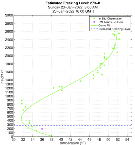
And aircraft coming into and out of SeaTac airport measure temperatures, and this morning at 8 AM temperatures increases from the lower 30s near the surface to the 50s above 2000 ft. Double wow.
Image from Seattle SnowWatch, funded by the City of Seattle
Hike to the top of Tiger Mountain today (at about 2500 ft) and you can have your lunch in bright sun and perhaps 60F, with your hike starting near freezing. My kind of hike.
High pressure will be hanging around through Thursday, after which precipitation will return to the Northwest. It has been a nice break from the rain, providing a chance for things to dry out a bit and lessening the chances for landslides and slope failures after a very wet period.
______________________________________
Important Update at 3:43 PM
With a strong inversion, there was a huge difference between the
temperatures at Tiger Mountain Family Nudist Park --37F-- (elevation
646 ft) and Poo-Poo Point (about 1550 ft) -55F (see map below). In fact,
Poo Poo Point, which is known for hang gliding, peaked at 57F.
So roughly 20F higher about 900 ft up. A very strong inversion.
I suspect the Nudist colony folks may be moving up the hill to Poo Poo Point today for obvious reasons. Stay tuned, this could get interesting!




Once in a while I make coffee from scratch on the stove top which requires that I use a digital temperature gauge to get the water temperature correct. When I put it in yesterday I noted that the water came to a boil at 214.3. So I went and looked at our barometer and sure enough it was at 1034. That’s about as high as I’ve seen atmospheric pressure in Wedgwood in NE Seattle and explains why water didn’t boil at 212.
ReplyDeleteMy barometer hit 1040 on Friday January 21st, never seen it that high before
DeleteWe are getting stagnant air warnings here in S Willamette Valley. Dreary, day long fog to go with the crummy conditions. Do not care for these extended dry spells during winter.
ReplyDeleteThere's a third effect of the offshore high:Consecutive daily rainfall records and considerable flooding in Juneau/SE Alaska as an atmospheric river is directed into that area.
ReplyDeleteTo add an anecdote, yesterday (Saturday) while riding the Skyline chair at Steven’s, half way up you could feel a pronounced rise in temp. I’ve never witnessed something like that. The inversion must have been sitting right across the hill.
ReplyDeleteLast night in Gig Harbor (Saturday the 22nd) the heavy overcast/low fog dissipated very rapidly right before sunset, revealing a clear sky with a very red sun setting over the Olympics. Was this coincidence for timing or just a lag between when the sun's action finally took effect? The air temp here dropped rapidly from 45.5F at 1615 to 38.5F at 1805.
ReplyDeleteNo one is going to comment on the nudists and poo poo point … OK.
ReplyDeleteSomeone already did..YOU
DeleteHi Cliff, what happened to th forecast today for N Bend? Was supposed to be in the 50s and clear by 1pm. Instead it was immersed in thick cold fog all day with temps around 37. The day before I climbed up to 4500ft and it was a summers day.
ReplyDeleteSadly out here a lot of folks are running wood burning stoves so the air is thick with pollution.
It's hard to give a perfect forecast. Your town wasn't high enough. As we descended from the pass this afternoon, the fog started at about 2000 feet.
DeleteSure but I'm interested to learn why the models failed in this particular location and the complexities of forecasting this phenomenon.
DeleteCliff - I think this would be an interesting topic for your podcast. I'd like to know how we can improve weather forecasting in mountain environments. I know that custom models used by mountain-forecast.com and windy.com are doing a fairly good job at forecasting remote locations, not sure how this works but their 'meteogram' feature has proven highly accurate for me personally along with predicted cloud base.
Also, I recall you stated that by integrating barometric pressure sensors into mobile phones would help with prediction resolution, is this still the case?
Something seems off about the update at the end of the blog...
ReplyDeleteNudist Park and Poo poo point.....
I skied up Amabilis Mountain today- about ten miles East of Snoqualmie Pass. It was 23 degrees when we started but quite mild in the sun up top at 4500 feet. And it was sunny all day.
ReplyDeleteLove those photos by Drs. Benda and Cobert.
ReplyDeleteSo it Monday morning 7:30 AM , Were down hear near Olympia, were out on a peninsula with saltwater less then 1/2 miles away on either side of us, The fog is not on the ground it looks like around a 500 foot ceiling off the ground , Its really weird its bone dry no moisture on the cars at all,. What's that all about Cliff its really strange ??
ReplyDeleteTwo weeks now of cold, dense fog in the Rogue Valley. I really should've escaped yesterday for Brookings.
ReplyDeleteVery interesting. I opened a water bottle and a thermos last night at my home in Olympia. Both had been sealed for several days and were at room temp when last sealed, and they hissed as I opened them. That doesn't usually happen unless there is an elevation or a temperature effect. But this was without either--just a high pressure system. Wow!
ReplyDeleteAlso, I went to Lake Cushman on Sunday (elev ~860 ft) and it was sunny and warm - t-shirt weather almost. Then down at Hoodsport (sea level) it was foggy and dark.
Two questions. First, is this a similar effect to the ridiculous heat wave we had last spring? I know that compression heating was the cause of that, as well, except that it did reach ground level, but you would know better than I if this is a similar situation>
ReplyDeleteSecond question: If this IS a similar thing, is this going to be more common in the future?
Beautiful chartreuse curve-fit of the aircraft temp observations! I wonder what kind of equation was used -- it looks like a combo of the best parts of a bell curve and a sine wave ;-)
ReplyDeleteThanks for this! Had a fantastic day cross country skiing at Snoqualmie yesterday. I would have overdressed if not for your timely post.
ReplyDeleteIs the topo map with temp readings for Poo Poo Point and Nudist Park available online? With current values? Thanks.
ReplyDelete