The great melt-out has begun in western Washington.
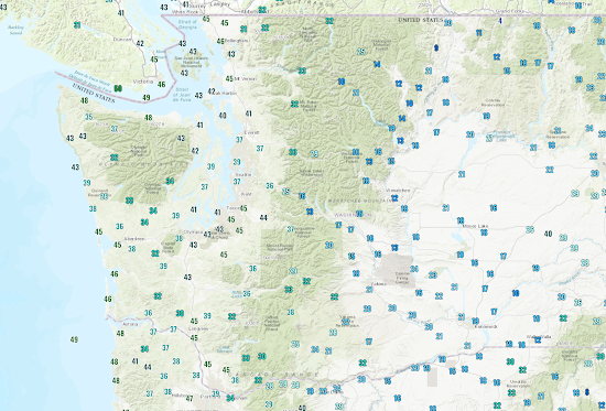
As shown below, temperatures have risen into the mid-30s to mid-40s in western Washington under the influence of moderate southerly flow in front of a cold front. Eastern Washington remains in the deep freeze, with some locations still in the teens.
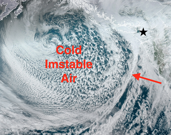
A moderately strong cold front is now approaching the coast (see visible satellite image around 1 PM, the star indicates Seattle). The warm southerly flow precedes the front. The snow level is around 2000 ft right now.
By tomorrow afternoon, the snow level will be down to 700-1000 ft, even a bit lower in heavy showers. Do not be surprised to see some wet snowflakes tomorrow if you are near sea level.
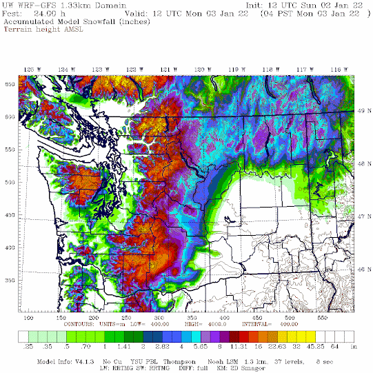
The predicted snowfall through 4 AM Monday is pretty impressive in the mountains, with 1-2 additional feet. Some extremely light snow (all melting) in the lowlands.
The big question is melting snow/ice on roadways. By tomorrow, many of the snow and ice-bound roads in western Washington will have melted out or become passable. Even today, travel is greatly improved around Seattle.
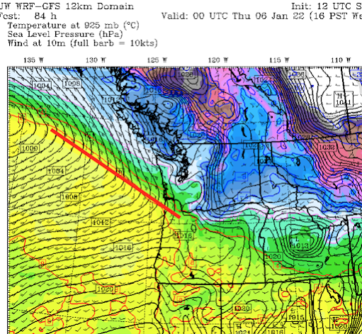
The next major action will be on Wednesday afternoon when a strong warm front will approach (see surface map for 4 PM Wednesday, warm front indicated by the red line). With cool air in place, some will see light snow that evening...but don't worry---the temperatures will zoom up with the warm front passage overnight and roads will be fine on Thursday.
_______________
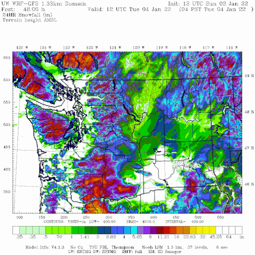
Several folks have noted that there was snow around Hood Canal and near the Olympics. This is not usual in such marginal situations, with additional lift on the SE side of the Olympic barrier. It was suggested in the model forecasts noted above, but let me show you the super high-resolution snow forecast from Sunday morning (see below). The Kitsap snow is pretty evident. Also snow in the Cascade foothills.

Cliff... Why only use one model in some of your posts? The UW-WRF-GFS is not flawless.
ReplyDeleteNo model is flawless. The UW model is the highest resolution model available with physics optimized for the region. Generally the best. But I do look at and show other models (e.g. I frequently show the ECMWF).
DeleteCold air held out in Hood Canal today, at 500 feet in Seabeck there’s 1-2 inches of snow through early afternoon. Rain at sea level.
ReplyDeleteMake it 3 inches
DeleteIt is not unusual to get snow around the hood canal area for marginal situation when it is raining elsewhere. Models did suggest this.
DeleteCheck my new update at the end
DeleteIt's been snowing here all day at our location near Lake Symington in Central Kitsap!! No rain OR wind!
ReplyDeleteHey Cliff we got heavy snowfall in seabeck.. and along the west side of Kitsap county. Do you think it could be a possible cold pocket that's going to set up over Kitsap peninsula?
ReplyDeleteSituation in central Kitsap is getting a bit serious. It keeps up like this all night its going to be VERY serious.
ReplyDeleteWind driven heavy snow with inch an hour accumulation at 500' above Hood Canal. Never got above 35 here today,but a mix of precip all day.
ReplyDeleteAlready three inches at Dabob Bay near sea level! 19:00
ReplyDeleteJust finally changed to all snow ..now snowing good on Newberry Hill in Silverdale.. easy over a half inch or so just in a matter on minutes.. going to stack up quick..
ReplyDeleteCliff it seems like the models missed this one. Some places in central Kitsap have 6 inches of snow, some have lost power from the heavy snow.
ReplyDeleteBen....the models did suggest it...check the high-resolution ones...cliff
DeleteVery nice, thanks Cliff. Good to see it was picked up in the models (NWS missed it). Although the snow totals are a bit underdone. This was a very serious event. Snow totals are underdone as well in Central Kitsap area, but still nice to see it in the 1.33. Some areas south of Seabeck at only around 500 feet received 8 to 12 inches. Many branches and trees snapped. Out clearing the road with a chainsaw... worst damage in years here.
DeleteCliff,
ReplyDeleteA huge fan and former student even! First time comment. I just took a screenshot of the radar image off the Weather apps and the vast quantity of RED level amount of rainfall that is solid from Bellingham to south Seattle and as wide as the PS basin is shocking to me. And another equally large wave hitting the coast and headed NE. I have never seen some much homogeneous red level precip in 15 years of checking radar. Did this catch the models by surprise that we might get 2+ inches of rain in 15 hrs? And I don't see any flood warnings yet at 8pm... Add the melting snow and this much rain and I can't imagine we won't have localized heavy flooding risk.
Cheers!
Snoqualmie Valley at North bend stayed under 30° sll day with wind and snow flurries.
ReplyDeleteSnowing all day in the Snoqualmie Valley at North Bend. Very windy and stormy temperature staying under 30°. Blizzard like conditions.
ReplyDeleteI witnessed the same. Forecasts were all completely incorrect.
DeleteI believe this may be due to the computer models mixing out the cold air too quickly as I think Cliff has mentioned this in the past. I saw from the nwac forecast that camp Muir was actually the warmest place as warmer air was filtering in aloft but the cold arctic air mass was trapped in the valleys. Would be interesting to learn the various nuances that cause these fluctuations. Was the warm air not strong enough or is it that mixing out cold air from valleys takes time and is difficult to predict and what would improve our models? Either way all fascinating subjects and I'm sure Cliff knows the answers.
DeleteWe just had 5+ thundersnow! Really cool! Lake tahuyeh near Seabeck
ReplyDeleteLooks like the no snow for lowland snow forecast was way off!
ReplyDeleteMichael..there was no general lowland snow. Nothing in Seattle for example....
DeleteClif... I believe there was lowland snow. Seattle isn't the only lowlands. Look up/research PNW convergance zone and lowlands. Everett got 3 inches or more; got so much that my gazebo collapsed and my satellite went out. That didn't happen during the days previous snow events.
Delete4" of heavy wet snow at 500' in Silverdale, even on the roads.
ReplyDeleteNothing melting in Index...
ReplyDeleteWhen do you see more cold and snow heading our way?
Delete11" of new snow in North Bend. 12"+ in Seabeck.
ReplyDelete6" of new on King/Sno line off Woodinville Duval Road (Woodinville address). Still coming down with wet heavy flakes. Happy Kids with school cancelled. Bummed adults. Lots of trees breaking with Heavy branches. Careful if you're in "Low Land" like this one.
ReplyDeleteA foot of new snow since last night, still snowing here above Hood Canal at 500'. Many trees down, blocked roads and general havoc in the immediate vicinity. Chainsawing the road out so I can start plowing the road.
ReplyDeleteGood times....
Lol
We got more snow last night in Lynnwood. It even knocked the dish offline for six hours because of the snow accumulation, which didn't happen during our deep freeze snow event.
ReplyDeleteFortunately, someone cleared a path for me to get to my car this morning, and I'm very grateful. This will be the first time I've been able to leave the house since before Christmas. I definitely have cabin fever.
And it's only the beginning of January!
Anyway, thanks for all your updates. I appreciate you.
We also received more here in Picnic Point area. Somewhere in the 2.5 inch range.
Delete10 inches this morning in Snoqualmie with lightning. Alternating between rain and snow all day
ReplyDeleteWe picked up a little over 2 inches here in the Picnic Point area of North Lynnwood. Very fast changeover from rain to snow late in the evening. The model anticipation for our area seemed to be very near the actual outcome, even if they were a bit on the low side as far as totals. I always appreciate your blogs and the detailed info you convey.
ReplyDeleteToday I was put in great doubt about my already minimal understand of weather forecasting. Can it be true?
ReplyDeleteI believed I had a general conceptual understanding:
Current measures of ever changing physical phenomena, along with understood constants such as the surface being water or land, mountain heights and configurations, the lapse rate, and others of which I could probably not guess, are put into a numerical model to produce a model of those same phenomena in the near future. That gives a weather forecast for the next day or other short term period..
Today I read this article
https://www.carbonbrief.org/guest-post-how-weather-forecasts-can-spark-a-new-kind-of-extreme-event-attribution
wherein it is claimed that weather models can provide good measures of how much human CO2 production influences particular weather events. It is done by running a forecast multiple times with differing CO2 concentrations.
My great surprise is that weather models would include CO2 concentrations, or even that there is any explicit knowledge of how CO2 concentrations can influence weather. CO2 concentration is a constant over weather forecast time scales. Why would it be part of the input data? IS IT?
Hi Cliff, are we still under the influence of a La Nina pattern, meaning the likelihood of lowland snow later this winter is elevated?
ReplyDeleteI find it interesting that many commenters who rarely (if ever) come on here feel the need to nitpick any forecast that deviates even slightly regarding the snow totals in micro climates. No one yet has been able to precisely discern the moment when rain turns into snow, particularly when you're dealing with slightly higher elevations in widely varying terrain. Perfect is the enemy of the good, ladies and gentlemen.
ReplyDeleteAnother 3" above Hood Canal last night, there's certainly no melt out occurring around here.
ReplyDelete