Meteorological winter in the Northwest typically ends the third week of February, and it looks like unusually dry conditions will dominate.
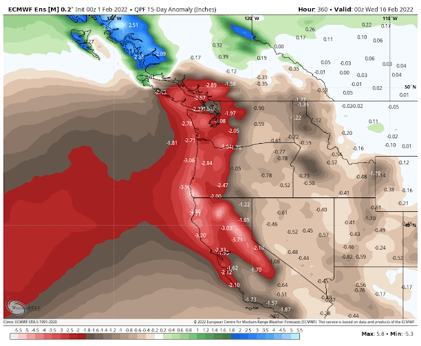
Perhaps the most skillful tool for extended prediction over the next two weeks is the ensemble of many forecasts produced by the European Center. The figure below shows the predicted difference (or anomaly) from normal for the precipitation through 4 PM on Tuesday, February 14th).
MUCH drier than normal (brown colds are 2 inches or more below normal) is predicted for much of the West Coast. This is particularly serious for California, which needs every drop it can get.
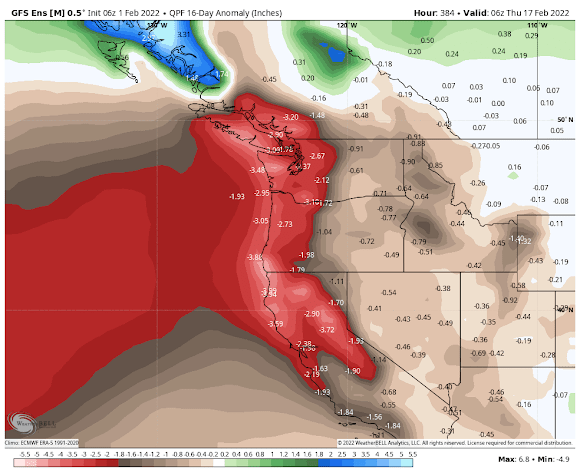
The National Service GFS ensemble system has a similar solution for the same period (see below). Very dry.
What is the origin of such Sahara-like conditions in the normally soggy Pacific Northwest?
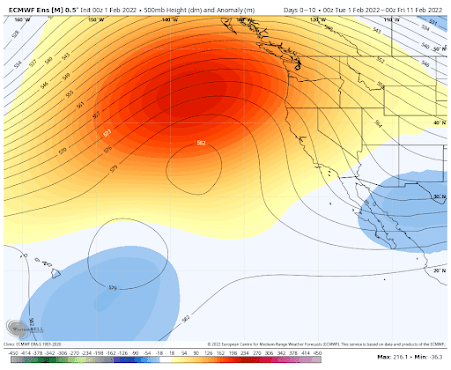
A persistent ridge of high pressure offshore.
Let me demonstrate that to you. Here are the predicted upper-level heights (solid lines) at 500 hPa (you can think of this like pressure at roughly 18,000 ft). The colors indicated differences from normal, with red indicating much higher than typical. A huge ridge of high pressure will dominate over the northeast Pacific).
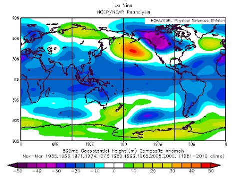
Thankfully, the Northwest has full reservoirs and normal snow as we go into this mid-winter dry period. Califonia has a decent snowpack but its reservoirs are still below normal due to the previous dry years. But at this point, there is still time for more precipitation after these dry weeks pass by, and it appears that La Nina is starting to weaken.
So stay tuned.


A compelling case could be made that "Winter" ended two weeks ago. Hopefully there is a shot of rain in March but it seems like we got all of our rainy season in concentrate form. Now its 8-9 months of "Ridge of High Pressure".....
ReplyDeletesounds good to me... more "CA"-like weather... certainly better than the opposite
DeleteCalifornians pay a very hefty premium to live there due in part mostly to the weather. Might want to be careful what you wish for.
DeleteI'm not quite ready to write off winter yet. I remember Cliff penning a blog early last Feb. saying we were running out of time for lowland snowfall and then we got hammered around Valentine's Day. Winter has a tendency to come roaring back!
DeleteWhy are you here, if you like CA-style weather? Personally, I find it oppressive and depressing. I loathe that weather; I grew up in LA and moved up here for a reason. I live for winter and dread that horrible "ridge of high pressure". I think it's extremely weird that so many people here in the PNW (including Cliff Mass) seem to hate the kind of weather that is (or at least used to be) typical for the area. If you like Southwestern weather, there's lots of SW you can move to.
DeleteWhat's really "amazing" and "extremely weird" is the difficulty the human brain has in tolerating the coexistence of disparate concepts. It is simplistic to believe that weather is the only reason one chooses to live in W. Washington. There are many wonderful things that enticed me to move from California to the Puget Sound region 40 years ago, but the weather is not one of them. I do not like the dark, wet winter weather here, and much preferred the climate in California. At the same time, there are many more things I really like about living here, and have no plans to move.
DeleteLike BAMCIS says, be careful what you wish for. I don't even want to imagine what our forests would look like if the climate turns into California's. The rivers reduced to smelly algae laden trickles and pools would be a disaster.
DeleteI moved up from SoCal too, like Heather. At the prospect of a Los Angeles-like February I vacillate between resigned despair and anger that we didn't address global warming decades ago when we could have done so much more easily. How much more tractable would the crisis be, if there were a couple of billion fewer people on Earth? We could have advocated for that, but we dropped the ball.
Great blog, BTW. I've been looking for something like this.
The California snowpack has dropped to below seasonal normal,as of today.Meanwhile, strong,dry northerly winds are rapidly drying out the lower elevations in the Bay Area and Sacramento valley.It was the driest January on record in places like Fresno and Reno.(Meanwhile, it also was the wettest January on record in places in SE Alaska,like Juneau)
ReplyDeleteLocally,this winter is somewhat similar to the 2008-2009 La Nina winter.That winter had an extended dry stretch from mid Jan until late Feb,until when more typical La Nina-like cool,wet weather resumed.
What you said about the '08-'09 winter similarities-- You're right, lots of similarities, including the bomb arctic blasts that happened both last december and december '08, where temps plunged below freezing for like a week. Very similar setups.
DeleteThanks for tying La Nina into your discussion! I was beginning to wonder how La Nina could be so dry. Thanks for the answer.
ReplyDeleteCliff, cpc is showing another very hot summer this year can we expect triple digit heat in seattle again?.
ReplyDeleteNow that's funny.
DeletePLEASE NO.
DeleteYou are a deceiver. Right now there are 6 or 7 high pressure centers from the pacific to the mid to upper midwest. Totally unnatural. Two days ago a low pressure vortex was spinning inside a high pressure dome. Unnarural. Massive weather manipulation all over the world. Just do some research as it is not even hidden any more.
ReplyDeleteWhat manipulation?
DeleteIF we could only manipulate away the high pressure ridge, that would be great.
So no historic mid February snow fall?
ReplyDeleteWhat defines "meteorological winter" and "meteorological spring?"
ReplyDeleteWinter ends at the Spring Equinox, and meteorology is the study of the weather correct? So isn't it "winter weather" AKA "meteorological winter" until March 31?
No, for meteorological seasons they go by the beginning of the month in which the solstice or equinox occurs. The season ends three months after that. I never heard of this until fairly recently, and depending on where you live it can seem counterintuitive. When I lived in L.A., summer didn't seem to get really going until mid July at the earliest; everyone knew not to go to the beach in June and expect it to be sunny and warm.
DeleteWeather manipulation was a very serious issue in the weatherman scene of southeast Tattnall County, Georgia in the time period between September 1981 - March 1982.
ReplyDeleteThis comment has been removed by the author.
ReplyDelete