We are about to encounter a meteorological roller coaster in the form of a heatwave spike, a one-day warm spell in which temperature will zoom upward by over 15F. And then, cooling as quickly as it warmed.
In western Washington and Oregon, spring is the time for heatwave spikes.The air aloft is still fairly cold, but the sun is getting MUCH stronger. Keep in mind that the sun this week is similar in strength to early September!
The key to all western /OregonWashington heatwaves is to have high pressure build to our east, producing easterly (from the east) winds. These winds warm by compression as they descend the western slopes of the Cascades. And easterly flow isolates the land from the cooling influence of the Pacific.
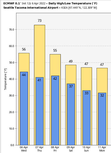
Below is the current European Center temperature forecast for Seattle Tacoma Airport. A predicted high of 56 today, but 73 tomorrow....roughly FIFTEEN degrees above normal. Then back to 55 on Friday and in the forties over the weekend.
The Seattle Times is even talking about snowflakes! (don't worry, that is not likely).
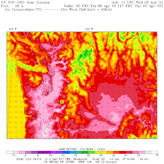
The latest surface air temperature forecast for 5 PM on Thursday will inspire you to dig out your tee shirts and fans (see below). 70s (light pink colors) from the Willamette Valley up into Puget Sound country. Warmer to the east of Puget Sound, where the downslope flow is strongest.
Note that this is a situation in which western Washington is WARMER than eastern Washington.
You must be asking yourself: what will cause such the spike heatwave tomorrow?
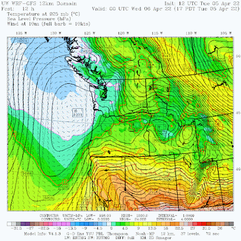
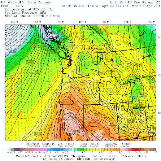
Let me show you, using some weather maps with sea level pressure, lower atmosphere temperatures (around 800 meters above sea level), and surface winds.
At 5 PM Tuesday, high pressure was just offshore, pushing cool air inland (white and blue colors are the coldest).


A light coating of ice on my car windshield this early A.M in S. Everett...almost an anomaly, according to your charts.
ReplyDeleteToo bad the warmth will not extend into the weekend! But with such a dramatic cold front, tell me that it'll come with thunder and lightning. Any other part of the country, it would.
ReplyDeleteI’m not ready for hot days, so I welcome the immediate drop in temp. But it reminds me that it’s about time to drag the portable AC up from storage to be on the ready to cool down our bedroom. In addition to being on the top floor of an apartment, our bedroom faces west and being just a few blocks from lake Washington, we get the sun all the way until it tucks itself in. Summer is probably my least favorite season, lol.
ReplyDeleteI prefer summer (with Spring in second place), which lets me do more of the things I like to do outside than any other season, but I agree: If you live in an apartment, you want a unit that faces south or east. East is probably best: You get the wake-up call from the sun, but are shaded all during the hot hours.
DeleteIt's hard to imagine anyone complaining about summer or hot weather in an area of the lower 48 that gets arguably the least of that kind of weather. We get maybe two months of warm to hot weather.
DeleteI'm not looking forward to 100+ again in Seattle but with climate change I think it's gonna be yearly now
DeleteHi Cliff, what's your prediction for the weather on Mt Ellinor on Saturday? Weather models seem to be confused with the GFS going for 50% chance of snow & windy and the Euro going for mainly sunny, few showers. Seems strange it can be much drier here than in the Cascades with 100% chance of rain, is this a rain shadow area? Thanks!
ReplyDeleteAccu Weather: Saturday evening - Late Saturday night. An inch or two of snow.
ReplyDeleteThat would be a Big Dipper.