One of the problems in being a meteorologist is that you suffer twice with bad weather: once with the forecast and then again when you experience the ill weather.
And the suffering is getting worse.
Tomorrow will be the last dry day for a long time, and this May will end up with rainfall more appropriate for February.
Let me show you the dismal story in 48-h chunks.
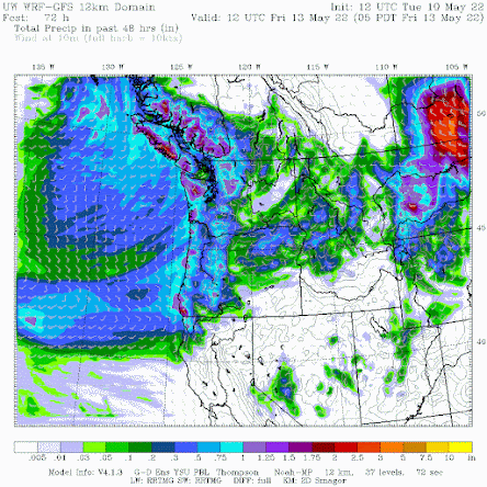
Wednesday will be mainly dry, but Thursday will be wet, with the 48-h precipitation total ending 5 AM Friday (below) showing a moderate atmospheric river coming in off the Pacific, with rain enhanced over the mountains.
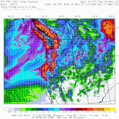
Over the next 7 days, the totals are...well..scary, with a number of mountain areas getting three to five inches. A lot any time of the year, but unusual for May.
Eastern Washington gets substantial rain, particularly in the "extreme drought" area from Yakima to Moses Lake. Rivers are also above normal within the drought warning area.
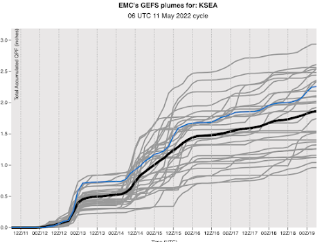
If you want to view the relentless nature of the upcoming precipitation, check out the prediction of rainfall at Seattle from the NOAA/National Weather Service GEFS ensemble system (see below). Each gray line is the cumulative rainfall at SeaTac for a different forecast and time increases to the right. The black line is the average of all the forecasts. Starting tomorrow, there will be nearly continuous rain, with SeaTac ending up with 2 additional inches.
Keep in mind that the normal TOTAL for the month is 2 inches and we already have two inches in the rain gauge. So we will have TWICE the normal rainfall by May 19th....and the month will not be over.
Now the really depressing thing is that normally there is a major warm spell in mid-May, one that always came like clockwork. But not this year.
Do you want to experience 70F or more during the next few weeks? Go to Hawaii.
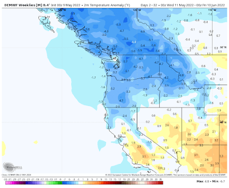
The latest extended European Center temperature forecast is predicting much colder than normal conditions into the end of June (see below, blue colors are below normal). Unbelievable.
Thursday will probably break the record for having the record low high temperature at many western WA locations.
Being cold and wet through May, with a bountiful snowpack, has major positive implications for the wildfire season, something I will discuss in a future blog.


This situation is sort of rare...then again, I can remember getting out of grade school, in the mid 1950s, around the 2nd week of June...I would usually put on my bathing suit, and amble on down to West Greenlake Bathing Beach...and then wait for the cloud cover to eventually burn off...sometimes it would not burn off at all, and even decide to rain a little, leaving me shivering with my beach towel wrapped around me, in the 60 degree weather!...this situation would last maybe for another three or four weeks!..But I would still show up, and hope for the best.By July, things magically heated up.
ReplyDeleteYes, a cool spring does not mean a cool summer so let's enjoy this weather now while it last because it won't last forever.
DeleteI recall some of that even in the 70's at times, but even then, it was often sporadic until after the 4th. In the late 70's at my first time at Camp Huston which is just east of Gold Bar and Startup, it was a cool, and damp session (2nd session). Typically 3rd session, and maybe the 4th session were the best weather wise as by then, the weather had finally turned "summer".
DeleteI think this is really awesome, last year everyone was ready to scream after the insanely high heat wave in June, yet those same folks are now screaming at the reverse. ANYTHING would be preferable to last year, as well as the massive forest fires here in OR the year earlier. Be careful what you wish for...
ReplyDeleteI'm with you. This weather is great and vastly preferable to 108 degrees and everything on fire. I'm genuinely enjoying this spring and hoping it makes for a pleasant summer. Here's to hiking in the snow in July!
Deletemeanwhile, in Colorado: https://www.denverpost.com/2022/05/10/colorado-snow-pack-melt-drought-fire/
DeleteVail just ended their longest skiing season on record. Here is OR Mt. Hood was similar, they just ended their season this week, and the area just received another foot of fresh powder over the past 48 hours.
DeleteNot looking great for our inaugural camping trip this weekend. But great news for water supply!
ReplyDeleteOn a slightly brighter note, I was looking a little bit at historical data, and noted the average high at SeaTac during this past week was 55.1 degrees. The normal high for today is 62.8 degrees. So we've been generally about 7 degrees below normal for early May.
ReplyDeleteThe long range forecast that Dr. Mass showed predicts ~3 degrees below normal for the next month. Additionally, this time of year the normal temperature increase by about 1 degree every 4-5 days.
Unfortunately, this week is only forecast to be barely better than last week, but the less cool long range forecast combined with the normal pace of mid-spring warming should mean it gets noticeably warmer soon.
In the meantime, it's hard to believe that the record high for today's date is 80 degrees!
This will be great for the cool-weather-loving plants in my garden!
ReplyDeleteI live at Desert Aire WA. Not very desert like here this year. It was 71' yesterday but we have had so much rain I have not had to water my garden much this spring. It has been very cold overnights also, mid 30's for this time of year is rare, yet it has been like this for a few weeks.
ReplyDeleteIn about 3-5 years maybe we won't have spring at all anymore, the way it's going.
ReplyDeleteAny chance some of the cool weather is related to the huge forest fires in Russia? I wondered if enough ash is thrown up into the atmosphere if it could cool off areas downwind, similar to a volcanic eruption.
ReplyDeleteYep, just about to start a long planned across the USA bicycling trip...
ReplyDeleteAs of today (5/12) it has been 317 days since last summer’s heat dome heat wave broke. If you look at the 317 days prior to the heat wave and compare them to the past 317 days, there is sort of a reverse symmetry. There were 183 (58%) warmer-than-normal days in the period prior to the heatwave. Since the heatwave there have been 183 (58%) cooler-than-normal days. Prior to the heatwave, the seasonally warmer days were about 4.85˚F warmer-than-normal on average. After the heatwave, the seasonally cooler days were about 4.3˚F cooler-than-normal. This is probably chance and more of a curiosity.
ReplyDeleteLooking back further over the past two decades, it appears the 365D trend line of average daily temperatures were elevated for much of the 2010s, but were slowly moderating back towards climatic normals at SeaTac the past few years (with obvious exceptions). This year’s strong La Nina seems to be aggressively pulling the long-term daily mean trends back to long-term climatic normals. Maybe that’s a good thing.
https://www.litterrocks.com/weather-charts-and-graphics/2022/5/12/on-balance
Nevertheless, I like summer and warm weather as much as the next person and have been dying this year for more recent normal spring temperatures and sun.
Full Disclosure: I know little of climate and weather other than what I read here and from other sources. I'm certainly no expert. I just like looking at public data, numbers and patterns and seeing if I can make sense of things.
Much of Thursday was sunny. In Seattle, and no serious rain on our drive home until we got to Gig Harbor close to noon. Much rain. Later in the afternoon got somewhat sunny again. Today, Friday it is looking like it will be good again until the early evening. Strange.
ReplyDeleteToo good information that you shared. It would be so useful post for those are searching for Historic Rainfall.
ReplyDelete