This spring is really shaping up to be remarkable.
Remarkably wet that is. A wet April, a very wet May. And it's not over.
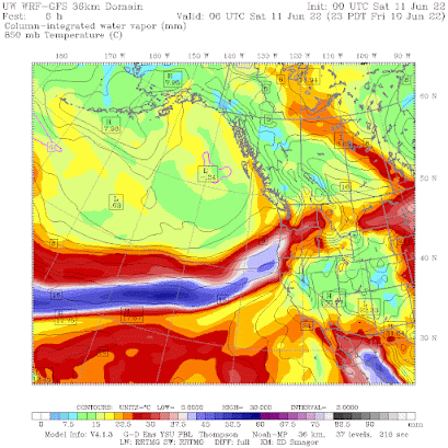
Today a strong atmospheric river is invading our region: one that would be considered strong even in midwinter.
Here is the image of the atmospheric moisture plume from off the Pacific for 11 PM Friday. Blues are VERY high values. And as this moisture ascends our local terrain, the result is heavy rain.
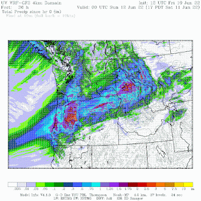
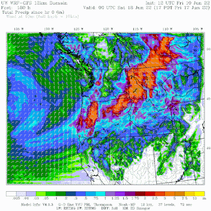
The precipitation over the next week is amazing. Another system will push moisture along the same pathway from the southwest. For the entire week, the region and northern Idaho will get hit very hard, with totals over 3 inches in broad areas. This is very unusual for middle June. Importantly, some of the precipitation will get into northern CA, where precipitation is very much needed.
Drier than normal in California, which is not good.
And with all this precipitation, the National Drought Monitor, has FINALLY dropped the severe drought over Washington State. About time. More on that in a future blog.


Drought folks still put 90% of Lincoln County as "severe drought". NOAA NCEI shared their overview of the map...but then its still a black box inside. Lincoln does appear to have lower rainfall, but then all the moisture and temp and SWE etc indicators are "wet" (to my civilian eyes).
ReplyDeleteWill 2022 end up like summer 1993, that is ultra cold and rainy until about mid August? I think it was July 12 1993 when it rained 2 inches in 2 hours.
ReplyDeleteThanks for that memory. I just checked our local climate record and while there were no 2" downpours we did have 5X the normal rainfall for the month. I suppose you have this climate site in your bookmarks? https://www.weather.gov/wrh/climate?wfo=otx
Deleteanything that delays the fire season is something to be celebrated IMHO.
ReplyDeleteFeels like global coding. I went up the Gillard road in Kelowna bc last weekend. Was very surprised to see how much snow still exists. And the bug! Hordes of flies like I've never seen
ReplyDeleteI recall the summer of 1968. It too rained and was unseasonably cool through winter. Lots of snow that winter too.
ReplyDeleteOne certainty is that the snowpack on Mt Rainier is currently at 134% of average. I checked conditions at Paradise a few minutes ago and there remains over 100 inches on the ground and the temperature is 38 F. Those are not typical June reports. https://www.nwrfc.noaa.gov/snow/snowplot.cgi?AFSW1
ReplyDeleteOver here in southeastern Washington, it is raining hard as I write this, as it has been all afternoon. And yesterday afternoon. And Friday evening. We ourselves haven't seen this much cool spring weather and this much rain in the thirty-eight years we have lived in this area.
ReplyDeleteOne more on your upcoming drought post-- what is drought exactly? Is it conditions today, or do they get to "forecast" and thus layer in various supply and demand "forecasts"? Also can it be normal Precip but somehow creeks are lower....is that evidence of a drought?
ReplyDeleteoff topic- would you ever publish "were the Yellowstone rains causing floods....predicted, or a surprise?
ReplyDeleteCliff, your thoughts on the Yellowstone devastation would be very helpful. As you might expect, it's difficult to get a straight story on how all of this developed from a weather standpoint. Love your blog!
ReplyDeleteThe Pacific Northwest never stops raining. Here we are in the middle of June and it's just as wet, cold and ugly as everyday is here through the year. The Weather here has changed dramatically. It did not use to rain non-stop like this years ago. We had rain yes, but nothing even remotely close the the Excessive amount of rain we get every single day here now. It's Miserable. Can't go outside to work on house or yard. Can't take your dogs for a walk. Don't dare go to the beach. It's a CONSTANT down pour of literally never ending rain here. What Gives? It's miserable. Every Single Day here it rains. If the Sun does come out for a mere 30 minutes and you try to go outside to get something done the sky will suddenly began clouding over and you find yourself in the middle of another daily torrential downpour. It's awful. June everyone finally looking forward to the Sun...but it never came. Instead, Again we find wet, cold, non-stop rain each and everyday. The Pacific Northwest has quickly become the region of Oregon that Never Stops Raining anymore. I don't know why anyone would be willing to travel to this Miserable wet region. Camping? Forget it unless you would like to remain wet and cold the entire trip. This is NOT the Pacific Northwest from years ago. This Climate is New is it Climate Change due to Pollution? Is it the Government messing with the Weather Patterns? Is it the Melting Ice in Antarctica or Ocean Pollution? I don't know but what I do know is the Pacific Northwest never ever stops raining anymore. It's Miserable, Depressing, CONSTANTLY WET, CONSTANTLY Cold Miserable State.
ReplyDelete