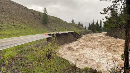
Several of the rivers in and around Yellowstone Park experienced record-breaking flows this week and my podcast today tells the story. And I also provide the forecast for the Northwest over the next week
As I discuss in my podcast, there are two main elements behind the Yellowstone flooding: (1) the melting of an extreme snowpack and (2) heavy localized rain. And to make this happen in such an extreme way, a lot of moving pieces had to come together.
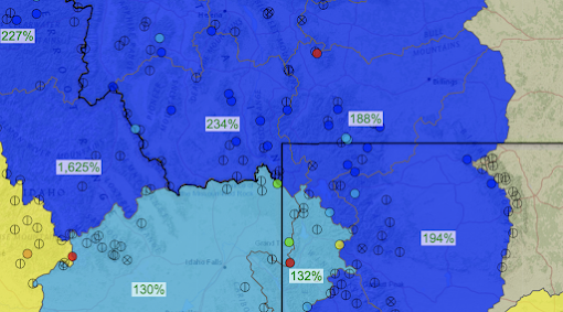
The snowpack on June 11th, right before the flooding, was extreme, with the regional terrain having snowpack water percentages of hundreds of percent above normal (see below). That means LOTS of water ready to melt. This snowpack was the result of our cool, wet spring.
June 11th snowpack percent of normal
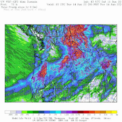
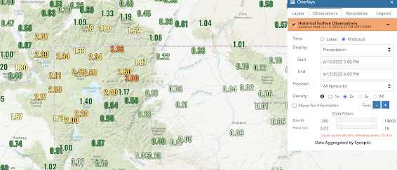
This rain not only contributed to the river rise but helped melt the snow as well. Take a look at a few of the regional precipitation totals below: impressive, with values as high as 3-4 inches over the weekend.
Another way to view the combined effects of precipitation and melting is to examine the observations at a USDA Snotel site, where both snowpack and precipitation are measured.
Consider the nearby Monument Peak, Montana location. The accumulated precipitation is black and the amount of water in the snowpack is shown by blue. Early this week the black line went up quickly (lots of rain) and the snowpack plummeted. A LOT of water became available for local rivers.
The evidence clearly suggests a minor role for global warming. The huge snowpack was a major contributor and global warming generally REDUCES snowpack. The position of key features, like the atmospheric river and a developing low over land, have no evident global warming connections.
The planet has warmed by roughly 1 C during the past century, and let's assume that humans are the sole cause. 1C increased would increase atmospheric water vapor by 6-7%, perhaps enough to slightly enhance the flooding, but nothing more.
The devastating event would have happened anyway.
To listen to my podcast, use the link below or access it through your favorite podcast service.


"1C increased would increase atmospheric water vapor by 6-7%"...
ReplyDeletecan have huge effect when conditions are primed for rainfall, such as with hurricane intensification, major frontal thunderstorm outbreaks, and terrain enhanced precipitation events.
Your statement in the Yellowstone Flooding article: " The huge snowpack was a major contributor and global warming generally REDUCES snowpack." is true but must focus on the word "generally". In the not-too-distant past, the weather was in a very complex equilibrium situation. It is being nudged by global warming out of this equilibrium, perhaps into a new equilibrium - perhaps centuries in the future. Such a transition has some general characteristics, but is also accompanied by wild fluctuations. So to argue that the huge snowpack was not a product of global warming is not at all conclusive. We just don't know.
ReplyDeleteYes, "we just don't know." Which pretty much encapsulates much of the climate "debate" these days. Meaning that there is no debate at all, just primarily composed of data that is not discerned by objective 3rd parties nor able to be defined as being predictive of almost anything regarding the future.
DeleteCliff, this year has seemed "darker" than my memory of previous years. That's however anecdotal, and not based on science. Is that issue one you intend to address in one of your posts or podcasts? How DOES this year rank where perceived, or measured, light is concerned?
ReplyDeleteI agree and was just telling my wife the same thing. Even on a completely sunny day the midday sun just doesn't seem nearly as bright or warm as normal. I don't understand what can cause this but it's making an already dismal summer feel even more drab.
DeleteYou know very well that percentages are a way to hide data. If no pack this time of year is normally 10 ft but now it's 20 ft that's a a lot of snow. But if it's normally 1 ft and now it's 2 ft that's less significant
ReplyDeleteI'm kind of weather radar junkie thanks for UW radar, Today's Radar images were interesting to say the least, large bands of rain moving on shore in central Oregon and swirling around then some sweeping off to the N. east and some heading N. west off shore toward the coast. not a normal pattern for sure.
ReplyDeleteI've asked this before, but shouldn't there be a mirror-image "September gloom" as the semi-permanent subtropical high retreats south from its July-August position (which, as I understand, protects us from the marine layer at it's northern extent by pumping air from the north, over Canada), whereas it pushes air from the west or NW in June as it moves north, and, I should think, September as it retreats southward?
ReplyDeletethe situation is not mirror image. the stability of the atmosphere is very different in fall versus spring for example
Deletethanks very much for this.
ReplyDeleteYour podcast mentioned of a system coming in this next weekend. Other forecasts e.g. Windy ECMWF have summer starting on Monday and running thru the extended, seems our annual drought could be about to begin. Does the Pacific high rebuild?
ReplyDeleteI drove from Coeur d Alene, ID to Butte, MT just before the main part of the event and was in heavy to moderate rain the entire time. In fact, it rained to ever lessening degrees for 100 miles south of Butte on I-15.
ReplyDeleteDuring a fuel stop in Butte, the guy at the pump next to me was commenting about how he had to change his entire fishing lure setup for this time of year since all the rivers were dramatically higher than normal and none of his normal tricks were working.