This fall has been wonderfully warm and dry in the Northwest.
Plenty of sun and perfect temperatures. My tomatoes have been glorious. And the warmth has reduced the need for heating, which helps reduce global warming.
But all good things must end and major forecat systems predict the transition to more typical cool/wet weather next Friday.
It is quite typical for the first half of October to be sunny and warm in our region, but on most years there is a transition to cool/cloudy/wet weather during the third week of the month. And this year is no exception.
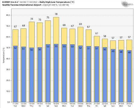
Below is the latest temperature prediction from the European Center's ensemble of many forecasts. One last warming period this week with a steady rise into the upper 70s by Sunday. Perfect weather for any outdoor activity. Then a minor trough of low pressure moves south of us early next week, dropping temperatures into the upper 60s. Still nice.
But the bottom drops out on Friday and Saturday, with highs only rising to the upper 50s.
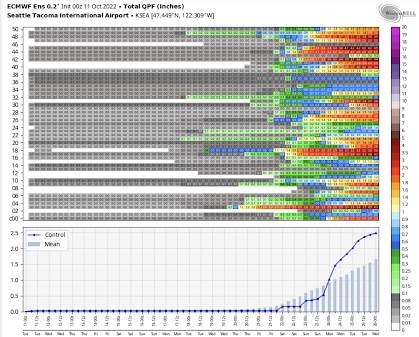
And they are going for rain.
Below is the cumulative precipitation from each forecast in the European Center ensemble (top panel), the forecast of the high-resolution ensemble member (blue line) and the average of all the ensemble members (light blue bars). This is serious rain folks (1-2.5 inches).
The key element of the transition is a major reorganization of atmospheric structure over the Pacific.
Let me show you.
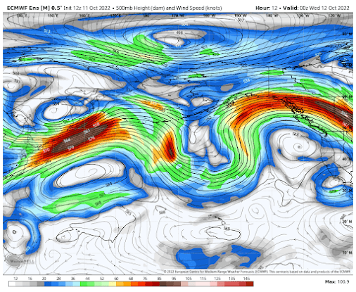
Below is the upper-level pattern (500 hPa, about 18,000 ft) for today at 5 PM (the average of the very skillful European Center ensemble of many forecasts). The shading shows the wind speeds.
Today, there are strong undulations in the height/pressures, with a big ridge of high pressure off our coast. The strong winds (the jet stream) go far north of us. A dry/warm pattern for the Northwest.
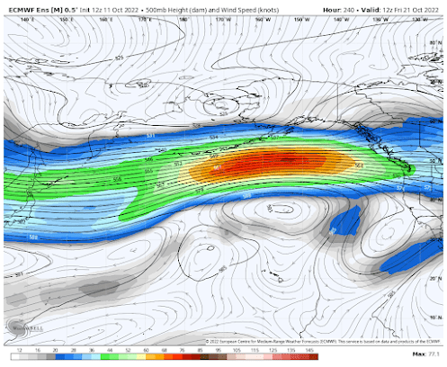
But now look at the forecast for 5 AM next Friday. Wow ...a big change. The wavy nature of the flow aloft is gone, replaced by a strong jet stream heading right toward our region.
The atmospheric firehose will be headed directly toward us.
Here is the total rain through Wednesday, October 26th. Substantial.
But we need to be careful. Forecast skill really declines after 7 days. But the consistency in time and between the major modeling systems is really suggestive that our warm/dry weather will soon be history.


Booooo
ReplyDeleteI noticed every time the models showed a wet pattern on the horizon this fall going back to mid September it ended up being warm and dry so I'm very skeptical about the coming change this time, I don't trust the models I'll believe it when it happens.
ReplyDelete"And the warmth has reduced the need for heating, which helps reduce global warming." Thanks Bill that's some top level misdirection. Got a water problem here for the fishies brewing. Did you blog on days without rain and that trend? Get yourself a nice bottle of Chardonnay with those savings those. Cheers!
ReplyDeleteDo you want to place a bet on that Cliff? My bones are telling me that the serious rains won't start here in Kingston until well into November. We may linger in drought and limp along until January and then it will hit us hard. Its as if this year our climate has become more similar to areas just out of the fog in northern California, such as Comptche inland from Mendocino. Welcome to California, Seattle. You are already there.
ReplyDeleteIf we could only avoid the smoke! I am so tired of this. The AQI east of Lake Washington this weekend was especially frightening. I am worried that Kitsap County will go up in flames at its current state of dryness. All we need is a bit of wind and some careless smokers, or someone going crazy in these unusual conditions lighting fires all over. Such serial arsonists do this frequently down in Southern California, simply to generate some excitement according to the clinical studies. I suspect these folks aren't limited to the Los Angeles basin.
Also, I saw a large white line heading North in the sky yesterday morning. These were a line of some 75+ snow geese flying at about 10,000'. Note - these were migrating North for the winter. Its usually the other way around.
ReplyDeleteGood thing that its going to be warmer apparently. Heating oil is at $5/gallon. We will miss our warm floors this winter and heat with wood. Its amazing how the African Blackwood scraps that I generate in my woodwind workshop heat up the house. And its essentially a carbon neutral activity given the number of trees we grow on our 2.5 acres. These include chestnuts which sequester a lot of carbon. The Filberts died from Eastern Filbert Blight and we've been burning that wood (this is what is recommended for disposal of infected wood).
Let's hope the forecast holds--- ready for some real fall here in northern Idaho!
ReplyDeleteAny chance this persistent high pressure will bring back the skier's nemesis aka The Blob?
ReplyDeleteThank goodness. I'll believe it when I see it though. Yes- one more sunny weekend will be nice. But some rain will help settle my allergies... There's still something in the air. And hopefully it'll put out the fires.
ReplyDeleteNOAA on eastern pacific warming anomoly. https://www.severe-weather.eu/global-weather/north-pacific-ocean-anomaly-2022-usa-seasonal-influence-fa/ Not as bad as last summer, but its been hanging around since July. Bet its influenced our dry summer weather and now warmer, driervddall.any thoughts, Cliff.
ReplyDeleteI'll appreciate the messenger that we will finally be getting rain.
ReplyDeleteCan one of the future posts include a discussion of the western cascades fire weather this year? It seems that there is a lot more smoke this year than one would expect by just looking at the metric of acres burned. I assume this is because the further west, the more vegetative mass exists in each acre. Maybe include a burnable mass metric that adjusts for fires that occur in forests vs the fires that occur in scrubland?
I bet this metric could be useful for short term weather prediction because soot in the air reduces air temperatures, so modeling that a forest can smolder for a long time may (slightly) improve the skill of 3 day+ forecasts.
In addition to the mass of vegetation we have on the west side (not only are these not grass land fires that can burn a lot of acres of low density vegetation quickly), it is also not very particularly dry vegetation. The east wind that started this dried the light fuels out very quickly, but the heavy fuels take longer to dry significantly.
DeleteAnd over the last several weeks, there has been fairly consistent fog, and daytime humidity has been moderate. Certain trees like Douglas fir actually gain a significant amount of water from fog if they are deficient, and even dead wood can over time slowly absorb water from being in high humidity conditions.
In short, the current west side fires have been smouldering, which also produces more smoke than than dry, hot burns. I wouldn't been surprised if some of the recent 100-200 acre days at the Bolt Creek Fire have produced almost as much smoke creeping through the underbrush as that first 7,000 acre day when the dry east wind had it burning hot through the crowns of a lot of trees.
This is good news! our salmon, trees and wildlife really need this, let's just hope the highly coveted luxurious European models are correct.
ReplyDeleteThank god, I’m sick of this weather.
ReplyDeleteAt the very least, the rains should put an end to this year's fire season. Surely a good thing, no?
ReplyDeleteThe temps and sun would be nice, if it weren't for the smoke. It's wreaking havoc on my asthma and allergies. Bring on the rain!
ReplyDeleteLooks like the models are again, backing away from this forecast with another ridge building in. Incredible, and somewhat frightening.
ReplyDeleteChris... no...the models are holding with the turn to wet conditions. What models are you looking at?
DeleteDo you have any updates on what the smoke might be like over the next week? The forecasts from wasmoke's blog look decent tomorrow but abysmal Saturday.
ReplyDeleteNo Cliff, this weather is NOT wonderful. If you like this kind of weather you should move to southern California, because this heat and smoke is terrible for the Pacific Northwest. The trees are dying, forest fires are out of control and smoke is in our air yearly for at least the last 7 years. For you to comment on this weather with such positive aplomb makes me think you deny that our weather here (and everywhere else) is very worrisome. Please just kindly stick with discussing the forecast and leave your personal opinions about this unseasonal heat out of the discussion.
ReplyDeletetmcb.... you are simply not correct. The trees are not dying, forest fires are not out of control. In fact, we have less fire this year than any year of the last ten. If you don't like my analysis, please read another blog...cliff
Delete"But all good things must end"
ReplyDeleteThe AQI (pm 2.5) in Madison Valley is 220 right now. Happy for that to end. Good grief!
People aught to calm down with the alarmist mentality... too hot, too warm, to wet, too cold... Climate Change!!! The weather has never just followed the bounds of "normal"... Infact, if thats all it did- I may be alarmed... lol. If you feel the need to cut your carbon footprint or whatever, do it- but chill 😎 and enjoy this weather while we got it- the rains will come...
ReplyDelete