Enough of the 1/2-inch snowfalls, more serious snow will hit the lowlands (and the rest of the state) on Tuesday.
Yesterday, some light snow showers reached the lowlands as cold air surged southward over the region.
Amounts ranged from nothing to about an inch at lower elevations, while more bountiful snow in the mountains brought a requirement for chains at Snoqualmie.

Light snow over Northeast Seattle.

Be careful driving: lots of slippery roads out there.
Today will be relatively benign and dry. But tomorrow is something else.
With cold air in place over the region, a Pacific weather system will approach. You can see the associated clouds on the latest infrared satellite image (see below).

This is not an ideal location of the low for lowland snow over Puget Sound--you want the low to take a more southward track and draw in cold air from the north as it approaches.

Less over SW Washington, where the temperatures are marginal but lots in the mountains (good skiing for the holiday period is guaranteed)
These kinds of marginal temperature situations are difficult and thus looking at many model solutions is useful. There is still (considerable) uncertainty regarding the exact location of the rain-snow line and precipitation distribution.
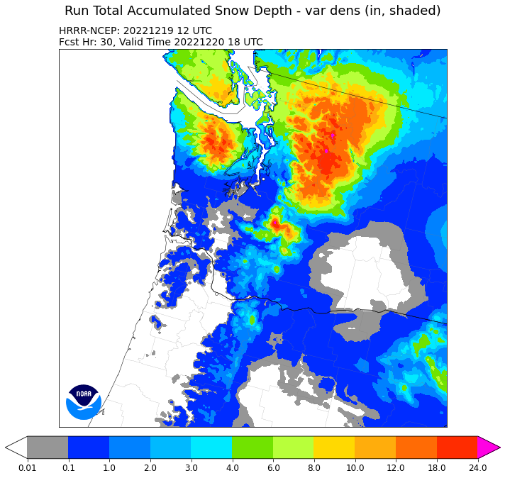
The UW model's snowfall total through Wednesday at 4 AM also has snow in NW Washington but also shows a rainshadow (snow shadow) north of Seattle, and more snow over the south Sound). But this is an older run than NWS HRRR forecast shown below.
.gif)
The European Center Model started more recently (10 PM Sunday), and also keeps most of the snow north of Seattle. And yes, large totals in the mountains.

All models bring fresh snow to the mountains of NE Washington.
Anyway, will keep an eye on the latest solutions, since this forecast is difficult with the southern edge of the snowfall area uncertain. It would be much easier to forecast snow in Nebraska, but more fun here!
I know it's more than 3 days out, but any comments on big warm up w/rain predictions starting next Saturday?
ReplyDeleteWhat's been mentioned in the past is the models are generally pretty good in the 3-7 day range for temperature ranges and likelihood of precipitation. They challenge can be figuring out where exactly a system bringing such a change in the weather will hit, creating uncertainty for those on the borders of the forecast area, and exactly when it will arrive.
DeleteWith snow in particular, because the lowlands are usually marginal temperature-wise, there is uncertainty whether they will be quite cold enough for snow, or else whether enough moisture will be present when a cold air system arrives.
But when I see a forecast for mid-40's and rain a week out, it seems like it usually plays out very close to that.
I would definitely bet on a mild, soggy Christmas.
It could be a real mess if warm rain falls on so much new snow. Looking at mountain forecast, the freezing level is predicted to be very high over the weekend into Monday next week, so flooding seems like a real risk. I'm certainly curious to see how this plays. It's an unpopular opinion, but I prefer my winters cold. We can save the 50 degree days for spring time.
DeleteI'm with you about 50 degree days at this time of year. Grew up in the Midwest, with bitterly cold winters, and unpleasantly hot summers. When people ask me why I don't like 80+ degree, long summer days, I tell them, think about how you feel about winter and then turn it inside out, and you'll understand. Someone once wrote that winter is the only season that has to be relearned, and that's a good observation. The days when it snows here are mother nature's way of telling us to slow down and stay safe.
DeleteLooks like the temperatures will be cold enough for once to keep the snow from being as wet and heavy (and slippery) as usual.
ReplyDeleteI see Wednesday night is the worst of the cold, with much of the region in the teens.
Dr. Mass, there is a peculiar extra cold spot I've noticed several times during similar cold spells. It is along the Snohomish River, in between Everett and the city of Snohomish, close to where I-5 and US-2 meet.
During Puget Sound cold spells, the forecast seems to put this spot 10-15 degrees colder than almost any other lowland location, and highly localized. For Wednesday at 10 AM, the current forecast is around 0 degrees, and again for Thursday at 1 AM. I don't have a good way to verify if these forecast low temperatures actually get met.
Just a 6-7 miles west in Mukilteo, at roughly the same elevation, the forecast is around 20 degrees. That is obviously influenced by Puget Sound, but even other locations a similar distance inland, and just 2-3 miles away seem to be forecast to be 8-12 degrees warmer. Here's a static link to one of the notable times:
https://a.atmos.washington.edu/wrfrt/data/2022121912/load.cgi?images_d4/ps_tsfc.54.0000.gif
If this localized cold spot strikes you as in any way interesting to you, I'd be very interested to hear any ideas why this cold spot shows up in the forecast.
https://youtu.be/mVIoSn28tW4
ReplyDeleteI like his delivery of the upcoming storm and his comparisons of different models and ensembles
It seems like we've had more snow the last few years. Is this the La Niña Threepeat, climate change, or both?
ReplyDeleteWe woke up to 8"+ in Bellingham and it's still snowing heavily.
ReplyDeleteWe finished up with 10" of Utah-grade cold smoke powder in S Bellingham. So beautiful outside right now!
ReplyDelete