In my podcast today, I spend the second segment talking in depth about atmospheric pressure. That information is particularly important this week:
A very large astronomical King Tide will be reduced considerably by much higher than normal atmospheric pressure.
Normal pressure at sea level is approximately 1013 hPa (hPa is the metric unit of pressure).
This week the pressure is forecast to be around 1030-1035 hPa! (see forecast below).
Such high pressure will reduce the high tide by roughly 7 inches. As you can see below, the water level predictions (blue lines) are substantially less than observed (red lines). This situation should continue for the next few days.As described in the first part of the podcast, a weak front will move through on Monday morning, followed by a dry week.
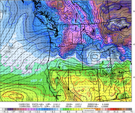
But excitement will await next weekend, as very cold air moves over the region (see forecast of lower atmosphere temperatures and sea level pressure for 1 PM Sunday). Blue colors are cold enough for snow.
Will there be lowlands snow over western Washington and Oregon? Stay tuned...


Is there a physical response to higher than normal air pressure? trouble sleeping? irritability? or sunnier dispositions perhaps? etc? Just curious.
ReplyDeletequestion: how can it be true that colder air sinks downslope to valleys but also that higher elevations are always colder than lower elevations?
ReplyDeleteI can't answer your question, but we live 260 ft above sea level on a steep hill just above Puget Sound. I regularly read temps on my car that show 2-4 degree warming as I drive up the hill. And like you, I wonder why there is snow on the mountains and rain down below.
DeleteWhile your question seems simple on the surface, it's actually quite complicated. For the first part, while it's true that cold air is more dense, it's only under very specific meteorological conditions that this actually manifests, and even then it's generally on a small localized scale. Mixing and other reasons prevent this from being true most of the time. Your second point, is because air is less dense with increasing altitude, which results in a lower pressure. Lower pressure results in cooler temperatures. Think back to your chem days, PV=nRT. Also, your second assertion that "higher elevations are always colder than lower elevations" is not true in an absolute generality either. Weather fronts often upset this balance, but only for a short time.
DeleteThe daily snotel reports are showing the Olympics and the central and northern cascades are below 90% now and appears to be dropping daily should we be concerned?.
ReplyDeletefirst shortwave dives south out of BC into Washington Thursday
ReplyDeletenight, with widespread rain and mountain snow into at least Friday
morning. The second shortwave Saturday into Sunday is where the
deviations really begin. WPC Cluster analysis has shifted the main
trough axis slightly further to our east, however. This keeps our
temperatures not as cold and reduces chances for lowland snow into
next week. As for now, highs look to drop from the upper 40s into
the lower 40s into this weekend. There is also growing chances for
strong Fraser Outflow Saturday and Sunday as the cold front pushes
south through the area with high pressure over eastern BC and
Alberta......this is from NOAA....looks like the cold air and snow is going to go east...another miss...