If you feel some pressure in your forehead today, there may be a cause.
Right now, the Northwest is experiencing unusually high atmospheric pressure.
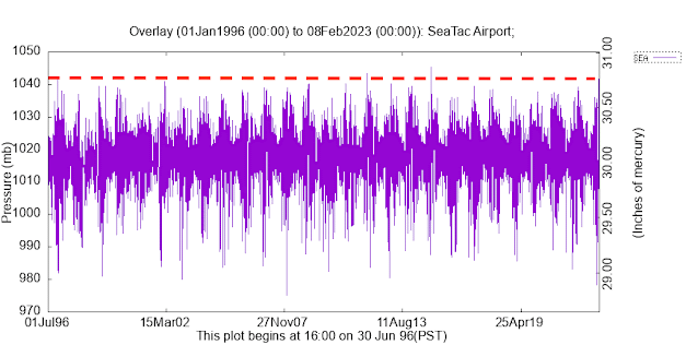
In fact, the third highest pressure in the past 25 years, hitting around 1042 hPa, something shown by the plot of pressures at SeaTac below (the dashed red line shows the highest pressure observed yesterday).
Later tonight and tomorrow morning, a front will move through, bringing some rain to the lowlands and snow to the mountains. Nothing exceptional.
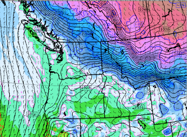
And then the chilly fun starts on Saturday. That morning, cold air (purple and blue colors) will start moving in from the Northeast.
The cold air will bring high sea level pressure and large pressure differences that will drive strong winds in and downstream of gaps in our terrain.
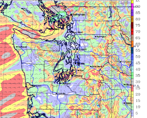
As shown in the wind gust forecasts for Sunday morning, powerful northeasterly winds to push out of the Fraser River Valley into Northwest Washington, and downslope easterly winds will descend the Cascades from North Bend to Enumclaw, moving westward in and south of Sea-Tac. Some bumpy landings can be expected.
And now I am going to disappoint some of you. Virtually no lowland snow will accompany the cold air. The set-up is just wrong.
Below is the accumulated snowfall through Sunday at 4 AM.
Perhaps a few flakes between Portland and Chehalis, but other than that, all snow will be at higher elevations. Good amounts in the Rockies.
Sunday and Monday mornings will be quite cold (in the mid-20s over the western lowlands), so disconnect hoses and keep your pets indoors.


Over on the Seattle subreddit (not the SeattleWA one), there was a thread yesterday from a tinnitus sufferer who said the ringing was particularly bad. Numerous other people chimed in with the same observation. I will share this post over there.
ReplyDeleteHi Professor Cliff,
ReplyDeleteI was wondering if in a future blog you could further explain why some of these arctic outflow events bring snow and others do not. For instance, why is this particular Fraiser event lacking in moisture as compared to other events in years past?
Signed, a snow and weather event aficionado.
Cliff has already explained this many times in past blogs. Or read his book...
DeleteSimply put, a wet front from the SW, and a cold front from the Frazer River Valley need to collide to get the snows. The big storm of 1985 comes to mind as they both collided, then stalled out for several hours, resulting in massive snow, with many areas of the mid to south sound getting upwards of a foot of snow that year, and it happened right before Christmas.
DeleteBut yes, Cliff has talked about this on several occasions over the past few years.
Our barometer here in Wedgwood in NE Seattle peaked at 1036 hPa, not as high as the official reading, but higher than our barometer has been at any other time. I was thinking it was unusually high. I'm not surprised by your news, but it is of note, of course. We're looking forward to the rain, and the snow in the mountains, but we're not going to miss snow here at City level.
ReplyDeleteBecause of the weather systems that we in the PNW and western US, has the snowpack in the headwaters of the Colorado River been sufficient to increase water flows in the coming seasons?
ReplyDeletehttps://www.nrcs.usda.gov/wps/portal/wcc/home/quicklinks/states/colorado
DeleteAs you can see, yes the Colorado River basin is above normal, but not by much. But honestly it doesn't really matter. The Southwest is continuing to pull more and more water so there is almost nothing the Colorado River can do to replenish Lake Mead/Powell. Short of numerous years in a row of 200% of normal SWE I doubt anything can be done. As Dr. Mass showed in a previous blog, the amount of water entering that watershed over the long term shows no statistical change. What has changed? The drastic increase in water usage from the Colorado River, that's why the reservoirs are so low and why it is so disingenuous by politicians to cry "Climate Change" is the reason. It's not, it's a booming Southwest population growth with poor at best water conservation efforts that are the actual reason for Lake Mead/Powell being so low.
Deletehttps://www.weather5280.com/2023/01/26/western-u-s-snowpack-and-reservoir-storage-update-new-drought-numbers-are-in
DeleteDoes pressure and humidity have any noticeable effect on how sound travels? The past two days while walking my dog in the evening here in Tacoma, it's seemed unusually quiet and still in a way I've had trouble putting my finger on. Reading this, I began to wonder if it had something to do with the abnormally high air pressure. Could be nothing, but I'm very curious.
ReplyDeleteYes, it does! In fact, for measuring acoustics, decibels (sound intensity) are a measure of air/sound pressure.
Delete