In a paper I wrote several years ago on western Washington snowstorms, I list several ways snow can fall in the area.
All had to find a way to provide precipitation and cold at the same time--which is very difficult in our neck of the woods.
One way to get snow...generally light snow.. is with the passage of an Arctic Front (really a modified Arctic Front, but who is checking?)
And we are going to get some snow from such an Arctic Front passage on late Tuesday and on Wednesday morning.
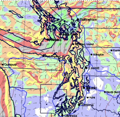
In a western Washington Arctic Front passage, cold air from the interior of British Columbia surges southwestward through the Fraser River Valley and jets out just north of Bellingham. The frigid flow splits around the Olympics with a river of cold air pushing southwards over Puget Sound.
The Arctic air collides with warmer/moist air to the south, pushing some of it upwards producing clouds, precipitation, and yes, snow.
Later tomorrow, the Arctic air will push southward, as illustrated by the forecast surface winds at 10PM Tuesday shown below.
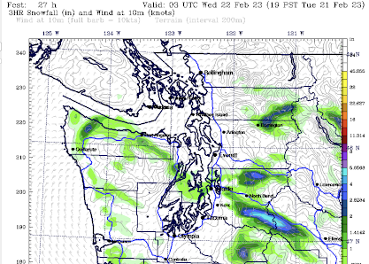
A band of snow will form at its leading edge, as shown by the forecast 3-hr snowfall total ending at 7 PM tomorrow.
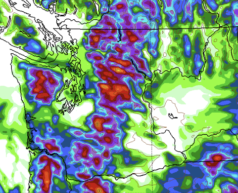
The predicted snowfall total (NOT SNOW DEPTH) Thursday morning shows .5 to 1 inch from south Seattle northwards, with more on the east side. Much more snow in the mountains A band of snow will also occur upstream of the blocking Olympics.
I don't want to hype this....not the end of the world. But many of you around Puget Sound will see some flakes. There is more snow over SW Washington, where they will get some precipitation from a weak low along the northern Oregon Coast.
The mornings the next few days will be cold....well below freezing, so be prepared.
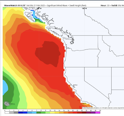
And talking about being prepared, some big swell will be approaching our coast tomorrow and Wednesday as well, with some waves above 20 ft. Strong northwesterly winds with a large fetch are a big contributor. Between the waves and the cold, not a particularly good time for cruising.


We're getting a lot of wind in eastern WA. Moses lake is still frozen but now the ice has broken free of the shore and with the power of the wind is taking out docks in slow motion. Nature's power is awesome to witness, I hope I have a boat dock come the morning.
ReplyDeleteJust out of curiosity, why do Tacoma and Olympia almost never see snow out of these events? Looking at the hi res map showing snowfall, Pierce and Thurston counties miss out yet again this winter.
ReplyDeleteBlame the Olympics. The rain shadow poops the snow party. In central/western Kitsap the rainy season is effectively over once the seasonal shift funnels the weather from either due west to east or out of the north west. This area's rainy season is probably almost a month shorter.
DeleteWhen I checked our barometer yesterday morning about 6:30 AM it was 1014 millibars. This morning, 24 windy hours later, it’s calm outside and our barometer is 995. That was an impressive fall.
ReplyDeleteCliff, setting aside the precip, the forecast models predicted the cold air about 6 days in advance, if not even earlier. I always thought a 6-day forecast was more or less a crap shoot. What do you think accounts for how well the long-range forecast performed re: the cold air in this case? Is long-range forecasting getting that much better, or was this a special case?
ReplyDeleteFrom what we see here in southeastern Washington, the 10-day ahead and the 5-day ahead temperature predictions are always much closer to the mark than are the snow and the rain predictions.
DeleteThe 24-hour predictions for rain and snow are quite a bit better -- mostly -- but even those are sometimes off, with substantial variation within the prediction area for locations at a similar elevation which are within ten or fifteen miles of each other.
As far as I understand, the models are pretty good at predicting the formation and general movements of air masses out to about 7 days, and have a decent idea even further out.
DeleteMore precisely where those air masses will move, exactly how much moisture they carry, and exactly what the temperatures will be each step of the way is harder.
So in this case, the model could recognize a very cold air mass was going to form and move from north to south, but seem to struggle with the exact temperature and how it would interact with the preceding warmer and wetter air mass. I think I watched the forecast lows for late this week bounce around by 12 degrees from last Friday through today (currently roughly in the middle of the range that showed up in different runs of the same model), but in all cases, it was clear the temperatures were going to be well below freezing.
2/20 was a very dark day around Bellingham - I measured just 0.79MJ/m^2 at my location; ~9% of the 8.22MJ/m^2 on 2/14 which the sunniest day of the year thus far.
ReplyDeleteAlmost 2 inches accumulated in Puyallup at 6 pm with no signs of it letting up.
ReplyDelete2/23/23, Tacoma got barely a half inch, if that in the grass, gardens and a mere dusting on cars and some on rooftops. Now it's mostly sunny and it's all gone. Saw a few flurries very late yesterday afternoon for a brief moment or 2 but we obviously got a bit more later.
ReplyDelete