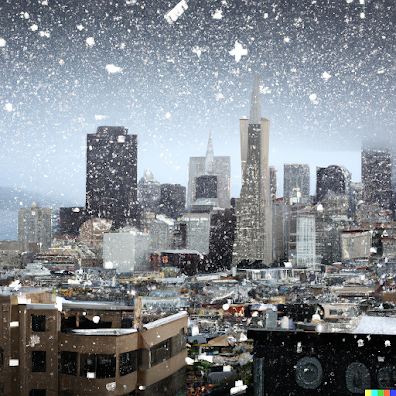
When one thinks of San Francisco weather one generally does not think of snow, but the latest model runs are going for flakes falling around the city.
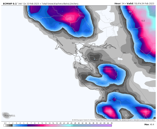
For example, the European Center's model accumulated snowfall forecast through 10 AM Friday has substantial snow on the hills around San Francisco, with snowflakes reaching the Airport.
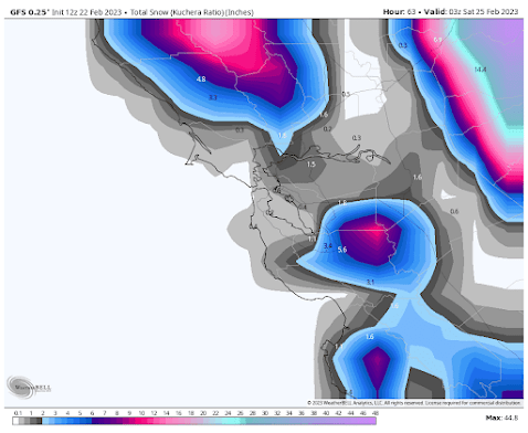
The U.S. GFS model has even more...snowflakes over the entire city!
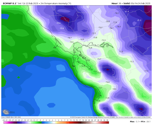
The media is going crazy with this snow talk for the "City by the Bay", warning of "wintry blasts". Highly dangerous conditions for the city's large homeless population.
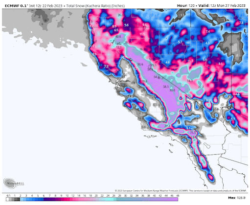
Huge snowfall totals are expected during the next week over California during the next five days (see forecast below). Yards of snow. And deep snow will even fall in the mountains of SOUTHERN California. Every California reservoir should be able to fill.
And a major snow event may occur over western WA on Sunday. But that will be discussed in another blog!

.png)
in the 70's there were two years (1973-74?) where there was snow in the East Bay hills... with snowflakes in downtown San Francisco. The airport is 12 miles south of the city of San Francisco. And, every few years it will snow on the higher elevations (Mt. Diablo, Mt. Tam, etc.) I don't find this "unimaginable" at all.
ReplyDeleteMaybe ask the natives and they will say " Snow in San Fran? Oh yah it happens all the time!" More often than not since we have been here!
ReplyDeleteIt has been snowing all day here in Olympia. Not sticking but pleasant to watch coming down.
ReplyDeleteIs this due, in part, to the polar vortex getting wonky lately?
ReplyDeletelooks like it: "The sudden stratospheric warming event was kicked into gear by planetary waves, or disturbances, in both the troposphere and stratosphere, noted polar vortex experts Amy Butler of NOAA’s Chemical Sciences Laboratory and Laura Ciasto of NOAA’s Climate Prediction Center.
DeleteA planetary wave in the troposphere at the end of January gave the polar vortex a minor bump from below, which they said caused some rapid but modest warming. That event likely destabilized the polar vortex enough that a weaker disturbance in the stratosphere about a week later triggered a total disruption and sudden stratospheric warming event, Butler and Ciasto explained. What the disruption will mean for weather down here in the troposphere is still uncertain, but sometimes these events lead to extreme cold air outbreaks in the mid-latitudes of the United States," NOAA said in a blog post last week.
Snow on the east bay peaks is not that rare, as Meetsy mentions. Mt Diablo gets snow every couple years, even Mt Tamalpais in Marin gets it every five years or so. Circa 2010 I was on the 30th floor of a building on market street and there were flakes outside the window, altho they were water by the time they reached the street.
ReplyDeleteHaving gone to school at Berkeley and Palo Alto I can attest that it can get pretty darn cold in the Bay Area with snow dusting the higher hills being fairly common. Now, east L.A.area under a blizzard watch; that's news!
ReplyDeleteUPDATE...As of 7 PM, snow was a bit more widespread than model
ReplyDeleteguidance suggests it should be this evening. Based on the recent
radar trends and overall short range guidance, expect the area of
light snow to persist for the next few hours while gradually
shifting west-southwest. The main impacts are expected from
roughly the King-Pierce county line southward and westward. Recent
reports of a trace to 3 inches of snow in Pierce County and the
current trends have prompted the expansion of the Winter Weather
advisory for this area through 4am. One benefit of this area of
precip is that temperatures may remain a tad higher in these
areas, limiting the wind chill/cold impacts.
In other words we didn't get the forecast right...it happens..rather have a couple of inches of snow than 22 degrees...
South hill Puyallup got 3" of snow and it got down to 25°. It's also been fairly windy, 10-15 mph with gusts to 28 mph. The high temp today was 33°.
DeleteMy freshman year at Stanford, it snowed. Palo Alto is about 35 miles south of SF, and is generally warmer, so I'm assuming it snowed in SF as well. A friend from Hawaii had never seen snow before, and everyone went out to slide in the foothills.
ReplyDeleteP.S. That was the fall of 1975 or the winter of 1976.
ReplyDeleteI lived in the East Bay suburb of San Ramon from 2006-2012. Snow on the upper reaches nearby Mt. Diablo (elevation ~3850 feet) happened a few times each winter. Only one time did I see snow atop the higher hills in the area (to the west of the city, a range parallel to I-680). Once, there were predictions for ½-1 inch of snow in the lowlands of the East Bay (it may have been February 26, 2011), so (on a trip to the East Coast at the itme) I changed my flight home from JFK to SFO from an evening flight to an early morning flight in order to get back to see the spectacle. And then it did not happen. I can only imagine what chaos would result from accumulating snow in the Bay Area.
ReplyDeleteCliff, any thoughts on the PDX snowstorm debacle? All the ingredients were here, we just didn't know the timing--so why be so conservative when predicting snowfall? It seems crazy to me that at 11:45am the NWS was declaring less than 10% chance of 1" or more of snow in PDX when Van/PDX already were seeing snow stick at 10am. Even at 3:45pm they were saying only another inch should be expected. Was this due to inexperience at NWS PDX? This isn't new, we had at least 3 similar scenarios over the past decade. News stations didn't take any of this seriously until it was too late.
ReplyDeleteCliff, are you going to talk about the forecast fail in the Portland area over the past couple days? As of yesterday morning, we were told we had a "30% chance" of "a trace to an inch" of snow in the low-lying regions of the Portland metro. Instead, we got 10.8 inches in 24 hours. We got clobbered, and no one was prepared. I just wonder, what happened? I know you're primarily concerned with Western Washington weather, but you have a lot of fans/readers down here in Portland. Thanks for all you do.
ReplyDelete