There are some situations that local meteorologists really worry about: when both temperature and precipitation are on the margin for snow.
And the situation tomorrow and early Tuesday is just like that....on the edge.
The latest UW WRF model run is painting a snowier picture over the western lowlands, as illustrated by the snowfall total through 10 AM Tuesday (below).
Several inches over north and south Puget Sound. General snow over SW Oregon and Portland. Loads of snow over the Cascades.
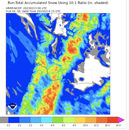
The latest NOAA/National Weather Service HRRR model forecast has most of the lowland snow over north Seattle (see below).
I should note there is plenty of uncertainty for the Puget Sound snow.In my podcast today, I talk about this situation and describe the complexities of this snowfall event. The "inner baseball" of westside snow, including rainshadows, convergence zones, and marine influence.
To listen to my podcast, use the link below or access it through your favorite podcast service.


Very interesting! I clearly see a heavy jacket of snow quite low on the trees - I'd say 1,500 ft or less here at 7:30 am - on the mountains that surround us here in Glacier (near Mt Baker). When I emptied the rain gage at 7 am (for the CoCoRaHS daily report), I could see that there had been snow in the morning mix (it's February, I keep a clean 'snow board' out). The ski area had 5" new, it's still snowing there, temps 25-21 F. So - yes, winter's not over and I do think something's brewing. I can see what's arrived, but keep us posted about "incoming"! (You have the tools to read those cards; hat tip.)
ReplyDelete