If anyone thought that La Nina would sneak away with little notice, the latest model predictions should disabuse you of that opinion: an extraordinary cold wave will occur next week, with several daily cold records destined to be broken.
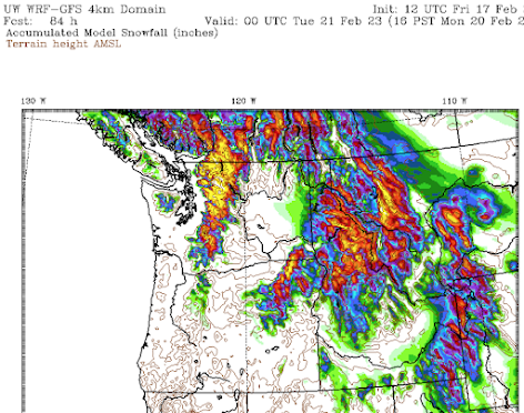
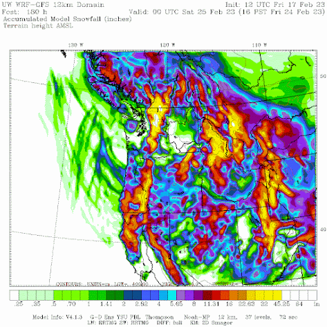
But there is more: huge additional snowfalls will occur over the mountains of the entire West Coast.
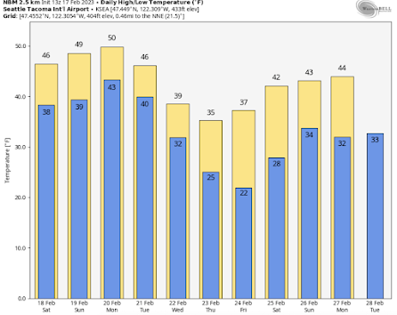
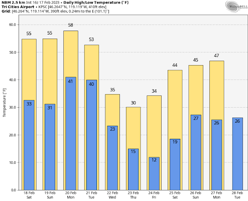
Let me start with the predictions at Seattle and Pasco, WA for the next week, based on the National Weather Service Blend of Models predictions.
There will be warming over the weekend into Monday, with a transition occurring on Tuesday as modified Arctic air pushes in.
The highs on Wednesday through Friday will be in the 30s, and the lows will be at freezing or below every night, bottoming out at 22F Friday morning.
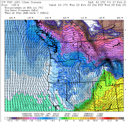
Now let me show you the maps of pressure and temperature (at around 2500 ft), which will give you a good feeling about how the Arctic is coming to us! I have waited until now to provide this discussion--holding off until we are close enough in time to have some confidence in the forecast.
Let's start on Tuesday morning at 4 AM (purple and blue are the coldest temperatures). Very cold air is poised to enter the NW...with the most frigid temperatures east of the Rockies. At this time, a cold front has just moved through western Washington.
By Wednesday morning, extremely cold air is moving southward east of the Rockies, with very cold air entering eastern Washington through the Okanagan drainage. Modified Arctic air is over the entire Northwest. Frigid northeasterly winds will be pushing through the Fraser River Valley towards Bellingham.
Pretty much the same story for Thursday morning, but colder. Life-threatening conditions in Montana. Any Chinese balloons falling there at this time would be all iced up.
Even COLDER on Friday morning, but a front with warmer air is approaching!



I was hoping we would now transition into spring. This will be the 4th cold snap. La Nina, go home! My first crocus came up 2 days ago. It is going to be lonely...
ReplyDeleteLooks like wiil have good snowpack to get us through another very hot summer on the way.
ReplyDeleteI hope it's a hot one! Getting excited about the tomatoes and flowers!
Deletewhy on earth would you think that the coming summer is going to "very hot" I wonder.
DeleteGreat news for California, their still in a moderate to severe drought as of yesterday's drought monitor update.
ReplyDeleteThe drought monitor severe drought business is not realistic. Drought Monitor is not a reliable source of information on drought intensity. Very unfortunate.
DeleteDr. Mass...if you could answer a nagging question for me. We all look at the weather app on our iphone, and I think it is weather.com models. Why in the winter do we see extreme cold days 7-10 days out that frankly, never happen. I saw a day in Issaquah that was predicted to be 28 hi, 13 low. Now it has moderated. This always happens. Now in contrast...in summer, I never see 10 days out that a 113 degree day is predicted like we saw a couple years ago. Something is off with the 7-10 day models in the winter. They alway over amp the "artic" push and moderate as we get closer. Love to hear your opinion.
ReplyDelete2nd this.
Deleteforecasts are not reliable 7-10 days out in either direction. That is why I generally wait until major events are less than 1 week out to talk about them on this blog.
DeleteThanks for the reply. I understand the unreliable nature of 7-10 days out, but my question is...why do the winter models often "spit" out extreme cold low temperatures and extreme low high numbers (predictions) that never, ever, materialize. Furthermore, I do not see this same extreme hot predictions in the summer, that get moderated. Winter models when they see cold seem to over amp the the cold then moderate the temps. I rarely see the models go for moderate then amp up the cold 3 days out.
DeleteIt's like winter models always predict the most extreme case then moderate, not the opposite.
For all its been cold this winter the snow quality has been terrible. Today i hiked up to 5000ft and the snow is wet heavy garbage due to the constantly fluctuating snow levels. Next week is cold then as Cliff mentioned another warm air mass so back to wet and sloppy.
ReplyDeleteIsn't a large high pressure system off the coast (steering the cold air to the south) more typical in the summer months?
ReplyDeleteNo...this is a classic pattern during la nina winters
DeleteThanks for the clarification.
DeleteYay! Primo cold's last hurrah.
ReplyDeleteIt snowed for two hours yesterday morning here in Glacier, and this morning the snow level was just about 1500 ft (I know the elevations, the features, of the mountains that surround us). "All I know is what I see" (observe) and it's been pretty normal - except for the early winter start (first snow here was in November).
ReplyDeleteSomeone said something about a "hot summer" coming. I don't know what would suggest or indicate that, at this point - what the 'predictor' would be.
His "predictor" is based solely on his feelings, apparently.
DeleteLocal Puget sound forecast seems to be moderating. Think that's accurate, or still likely to get a surprise 20F night?
ReplyDeleteIs there any relationship between this big high steering cold weather to us and the Kona Lows that have been clobbering Hawaii?
ReplyDeleteAnother much ado about nothing. Mr. Mass seemed to have nailed it with this blog. Other weather forecasts were predicting highs barely making it out of 20s and low 30s. This forecast seems more reasonable. Even national weather service had us pegged for an arctic even. Now it just looks like a couple of days in the high 30s and moderating thereafter. 8 to 14 day forecasts still showing deep blue, indicating very cold air likely. This is a major bummer, as I once again thought maybe, just maybe we might actually get hit with a true arctic event that might actually last a week or so. Anyway, we get what we get.
ReplyDelete