One thing that really stands out this winter has been the lack of heavy rain over western Washington, particularly since the start of the new year. One hardly needed an umbrella for the past few months.
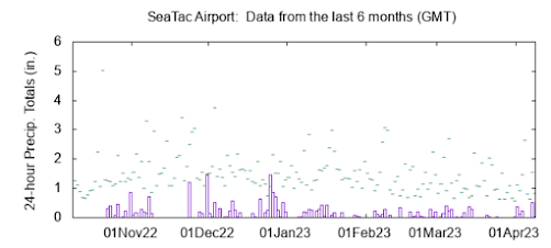
To illustrate, below is a plot of the daily precipitation over the past six months at SeaTac. A handful of wet days (up to 1-1.5 inches) in December and then the spigot turned off in 2023, with the wettest days only hitting around 0.5 inches. I have cycled to work pretty much every day.
.
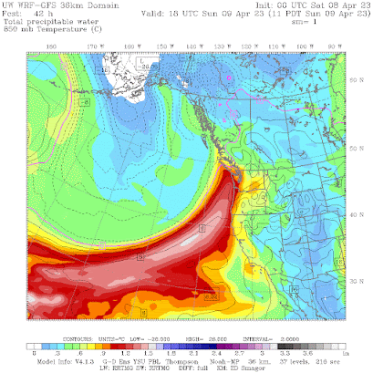
A big change in all this will occur over this weekend. A strong atmospheric river of substantial moisture will be directed into the Northwest on Sunday and Monday (see the forecast of atmospheric moisture below for 11 AM Sunday).
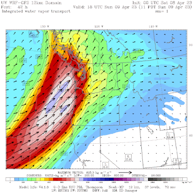
This moisture plume will be backed by strong winds from the southwest, resulting in moderate to strong levels of moisture flux (moisture times winds), which is a measure of how much water vapor is being pushed against our regional terrain (see below).
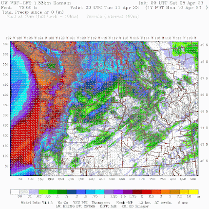
As you can imagine, the impact of all this incoming moisture will be substantial precipitation over the region, as shown by the predicted totals through 5 PM Monday (see below). 3-7 inches in the mountains and a substantial band over southern Puget Sound.
As shown by a close-up view of the predicted precipitation, there will be a profound rainshadow northeast of the Olympics, with Sequim, Port Angeles, and Victoria being relatively dry. SeaTac Airport will be wet. Very wet.
This event will bring substantial warming aloft and by the end of Sunday, the snow level will rise to at least 6500 ft. The mountains will be challenging, first heavy snow followed by heavy rain. Rivers will rise rapidly around the region.
Time to find your umbrella!

.png)
.png)


.gif)
The current NWS forecast for the grid square in which my location in Bellingham resides is calling for north of 1" of precip through the period which the graphic depicting precip amounts predicted by the UW WRF-GFS model shows, while the current Weather Underground precip forecast for the location and periods in question is ~0.6".
ReplyDeleteGiven the expected strong rain shadowing to the northeast of the Olympics, I suspect that the current NWS forecast precip amount is overdone for my location and that the observed amount will be closer to that of the Weather Underground forecast.
4/8 was an unusually breezy day at my location in Bellingham with an average wind speed for the day of 11.3mph, though it was not notably windy with a max gust of only 33mph. The most recent instance of a day with a greater daily average wind speed was 1/2/22 with an average wind speed of 14mph and a max gust of 47mph.
ReplyDeleteThis is a great example of how water levels are not dependent on one season. Every season matters. We were a bit lower than average at the end of winter, and by the end of this week, I assume we will be above. If the spring had been warm and dry, it would be the opposite.
ReplyDeleteI am in Bellingham and we are having wild winds right now (about 1 PM). I am curious, are the winds caused by pressure differential between the area in BC north of the Fraser River and the low that causing the rain? Are we experiencing a Fraser outflow (or maybe Fraser inflow)?
ReplyDeleteIt has indeed been breezy in the Bellingham area today though it appears that (as is often the case) BLI takes the cake with a very impressive 64mph gust just before 1PM. My mechanical rooftop anemometer peaked at a comparatively meager 42mph from the southeast at around 130PM and my sonic anemometer (at about half the height of the one on the roof) topped out at just 33mph, also from the southeast, at a bit before 1PM.
DeleteThe strong southeasterly winds that affect the so-called "north interior" of Western Washington, along the eastern margin of Puget Sound, and the northern inland waters from about Everett north, including Island, Western Skagit, Western Whatcom and San Juan Counties, are characteristic of a particular (and relatively common) track that mid latitude cyclones moving inland from the Pacific with low pressure centers located to the north of Washington take, usually from Vancouver Island to the Queen Charlotte Islands. These storms are colloquially known as "southeast suckers" and generally do not produce notable wind speeds south of Everett, where terrain barriers (e.g. the Olympic Peninsula) interrupt airflow, and its strong easterly component in such setups, by reducing the length of open terrain (or water), or fetch, over which winds have to accelerate.
The source of the winds themselves is, of course, pressure gradients which are aligned along the frontal boundaries (occluded, warm and cold) which emanate from the barometric pressure minimum that occurs at the center of the cyclone. These gradients are usually strongest to the south of the low pressure center. The timing of the strongest winds in any particular area is directly related to when the pressure gradient is tightest near that area which is generally along and ahead of the frontal boundaries in the case of "southeast sucker"-type events so changes in wind speed and direction are usually good indicators of where a front is located relative to a given location.
With "southeast suckers" it seems to be the proximity/passage of the warm and/or occluded fronts that's responsible for the strongest winds in the Bellingham area whereas the proximity/passage of the cold front usually produces the strongest winds in other parts of the state or when the track of the low pressure center is further to the south.
As I'm writing this comment, the temperature has decreased from the mid to low 50s, winds have eased dramatically and begun to exhibit a westerly component to the overall southerly direction and the rain has finally begun to fall in earnest - strongly indicative of imminent or occurring cold-frontal passage.
Professor Mass, perhaps you'd be willing to devote a post to "granularity" as it pertains to weather forecasts and climate models. "Data granularity is a measure of the level of detail in a data structure. In time-series data, for example, the granularity of measurement might be based on intervals of years, months, weeks, days, or hours."
ReplyDeleteThere are quite a few heavily relied on weather stations that are located in what seem to be convergence zones. Atmospheric science is very much a 3D affair, three dimensional, and I expect that "convergence zones" occur vertically as well as horizontally, so to speak (beyond east, west, north, and south). It would be interesting to know what the density of data is. You've written many times about radar blind spots. All these factors must have bearing on the accuracy of both look-backs and forecasts. Tell us more :)
We live in a convergence zone area GlacierBake, 3 miles north east of Arlington up against Stimson mountain, it sure rains more here than Stanwood, Mt Vernon and Everett. Just last night we received 1 6" and after most cold fronts it will rain almost all day, especially if the flow onto the Coast is more of a southwest flow, and sometimes during a northwest flow a convergence zone will form from Vancouver Island instead of the Olympics
DeleteThis appears to be a continuation of the parade of atmospheric rivers from the central Pacific this year shifting north? How many so far 14, 16 ?
ReplyDelete