This past March brought record cold to a vast swath of the U.S., including the West Coast and the northern Plains.
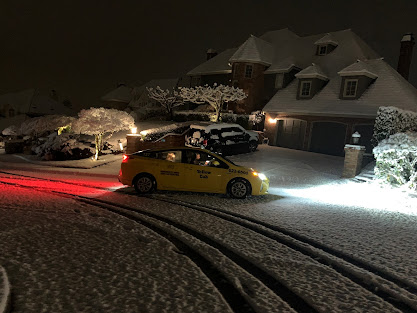
Here in Washington State, the frigid conditions even continued into April, with snow showers falling to sea-level and serious snow on some of the hilltops near Seattle (see the snowfall at 1100 ft in Bellevue on Sunday night). April?
April 2. Bellevue, Washington at 1100 ft. Courtesy Dr. Peter Benda
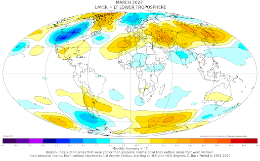
Satellites can observe atmospheric temperatures from space. The lower-atmosphere temperatures for March from such satellite (see below) indicate that the coldest temperature anomalies (differences from normal) on the planet occurred in a swath from the West Coast to the upper plains.
Portions of eastern Oregon had had their coldest March in history, as shown by the March temperatures at Burns, Oregon over the past 50 years. I mean no year was even close to March 2023.
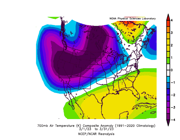
A NOAA temperature analysis that presents the differences from normal of temperatures around 10,000 ft (700 hPa pressure) for March is shown below.
Stunning. The temperatures were HUGELY below normal over the western portion of North America, but above normal over the southeast. This produced a very anomalous change in temperature (temperature gradient) over the middle of the nation.
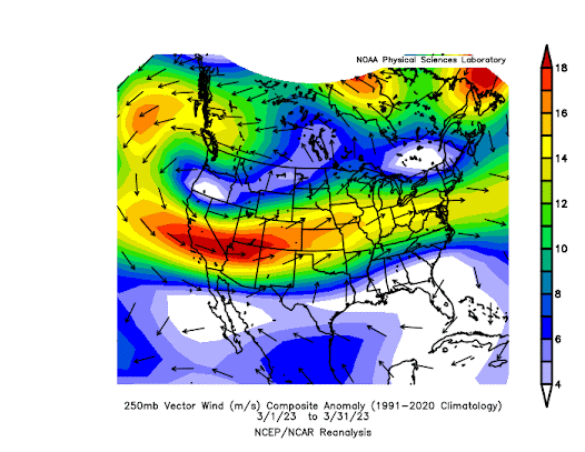
Big horizontal temperature changes are associated with strong jet stream winds in the upper troposphere. So it is not surprising the jet-stream level (~30,000 ft, 250 hPa pressure) winds were much above normal in the area with anomalously large horizontal temperature changes (see below).Red, orange, and yellow colors show where winds are much stronger than normal, with the most anomalous jet stream winds from California to Colorado.
The large temperature gradients and strong upper winds have been favorable for the strong thunderstorms (and severe weather) over the eastern portion of the U.S.
This historically cold March weather in the west has been a godsend in one way: it slows the melting of the massive snowpack in California.
A rapid warm-up would be very dangerous, leading to serious flooding.
The weather for the next 15 days?
You guessed it, colder than normal in the West (see forecast temperature anomalies below). Blue and green colors indicate substantially below-normal temperatures.
My advice: don't think about buying tomato plants in April.


.png)


People are complaining about the cold now but remember what happened last spring it was wet and cold also, followed by one of the hottest summers on record. I suspect this summer will be just as hot too.
ReplyDeletetim... there is no reason to expect the summer to be warmer than normal. And the chance of being as warm as last summer is very remote....cm
DeleteCliff, I think the assertion that "there is no reason to expect the summer to be warmer than normal" is negated by the fact that the Climate Prediction Center monthly/seasonal outlooks currently predict a warmer than normal summer for the PNW.
DeleteObviously, the CPC outlooks are long range predictions that are subject to change, as we've seen recently with regard to the predictions for the upcoming month, but the idea that, at present, "there is no reason" to expect a warmer than normal summer is clearly false based on the CPC outlooks as these predictions would seem to constitute "a reason" regardless of the extent to which one regards them as such.
Friend..you are not correct. The CPC seasonal outlook has very little skill. Have you ever verified them? I have. The more skillful European Center seasonal outlook is for near normal conditions. Both CPC and EC are going for a cooler than normal spring...cliff
DeleteI hope that the CPC is right this time, though: This winter has gone on long enough.
DeleteThe fact is no machine nor person can regularly accurately predict what the weather will do on one particular day or set of days more than a few weeks into the future. That, and just because spring was cool and wet doesn't automatically mean a blazing hot summer will follow. Please stop posting alarmist bunk.
DeleteOne reason to suspect it will be a hot summer is... “last spring it was wet and cold also, followed by one of the hottest summers on record"
ReplyDeleteThe trouble is, inductive reasoning just doesn't work with weather- in either a positive correlation or a negative one.
DeleteCorrect. But that also does not mean there is 'no' reason to expect
DeleteIt appears there may be reason to be hopeful about some alleviation to the current Whatcom County precip deficit as recent evolution in the forecast for the next month indicates cooler and wetter than normal conditions are expected.
ReplyDeleteThough it wasn't quite as cold at BLI, with a morning low temp of 31, as it was at my location (29.3F), had it been as cold at BLI as it was at my location it would have tied the daily record low temp set in 2021.
ReplyDeleteTo answer your recent question, when folks send me 4-10 comments a day, I generally only select 1-2. To much work form and unfair to other radars for one person to try to dominate the comments
DeleteFYI...the latest record instance of snowfall in Seattle, happened way back in 1927...April 19th. But there was also just a trace of snow recorded in 1947..May 2...only in downtown Seattle!...So, maybe we are not yet done with snow!
DeleteFair enough. Point well taken and appreciated!
DeleteYes curbozer, back in 2008 we had 5" of snow on May 5th here just north of Arlington at 400' elevation, that was quite the surprise!
Delete